






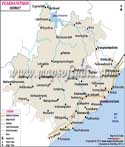
About
The East Godavari district is one of the most historic and historically very rich districts with a rich cultural heritage. The district is pictured in all its melodramatic state as it may be painting the last drawing of some great screen tragedy, sweeping out lush fields, sinuous waterways, ancient temples and centuries-old villages that have stared down decades of social and political turmoil.
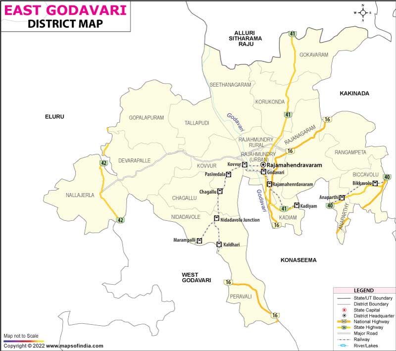
The district is located in the north-eastern part of Andhra Pradesh and was reorganised in 2022 when certain districts of Andhra Pradesh were carved to create new ones. Kakinada has been the home of the administration of East Godavari district as it is today. Its significance shall be recognised for its contribution in various sectors of the economy including agriculture, trade, tourism, culture and education in the state. When this district is seen in the East Godavari district map, it looks like a strategic corridor between inland farming areas and coastal economic corridors. The district is one of the most productive agricultural areas in southern India, under the domination of the fertile Godavari Delta.
History & Culture
History is not still in East Godavari. It has been marked with ancient kingdoms, trade routes from sea and land, religions and colonial influence. This area was an integral part of the ancient provinces of Kalinga and Andhra. There is evidence of inscribed and archaeological findings that herein organised settlements thrived for centuries.
The district had many prominent kingdoms including Satavahana, Eastern Chalukya, Cholas, Kakatiya and finally regional kingdoms. Rajamahendravaram (also called Rajahmundry) was developed in great administrative and cultural centre by the Eastern Chalukya dynasty. In looking at East Godavari district map, historians will usually comment upon how differing river routes determined the course of military campaigns, trade and the spread of faith.
Culture in the district plays itself out like a well crafted script. It was also a major source of contribution to the Telugu literature. Nannaya, who was the first poet in Telugu literature, was linked to the Rajamahendravaram. Temples, classical music, dance and literature are a number of local cultural characteristics that give their own sense of identity to the local people. The East Godavari district map also shows that many cultural and religious centres of importance, attracting pilgrims for centuries, are within close proximity of the East Godavari district.
The festival gives the rural and urban areas a fresh coat of colour with days that are beautifully decorated, traditional stages and gatherings. In the festivals of Ugadi, Dasara, Deepavali and other temple festivals, one can see different backgrounds of various types of people who come together to celebrate. Traditional dishes based on this agricultural abundance in the district are rice, seafood and local delicacies. Here, the culture is not just recreated, but played out each day in language, rituals, arts and customs.
Economy
The East Godavari economy has a large production set in which many stories play out at the same time. In agriculture-based economies, it is still the bedrock of the economy. The soils of the fertile delta can accommodate large-scale farming of paddy crops, coconut, sugarcane, pulses and horticultural crops. For decades, the Godavari irrigation system has dramatically contributed to the agricultural prosperity.
Public administration, education, healthcare, irrigation management and rural-development programmes offer large employment opportunities within the Government Sector. Welfare schemes, infrastructure and agricultural support are all controlled by government institutions. Through an East Godavari district map, planners tend to look at and speculate on a district to grow economically while simultaneous help understand the irrigation networks and administrative divisions.
The Public Sector has been a strong contributor towards Industrial and Infrastructural development. Energy, transport infrastructures and public services have created jobs and reinforced regional links. The wider coastal area includes ports and logistics hubs that boost the economy. The adjacency of the public sector initiatives/investment with coastal areas and transit links is illustrated with the help of an East Godavari district map.
The Service Sector has grown at a fast rate over the years. Banking, education, healthcare, retail trade, tourism, hospitality services, information technology services and transportation services together are white collar employers of a large number of residents. Students from neighbouring districts are drawn to the educational institutions and businesses are awake to the commercial centres. With the emergence of digital services and modern commerce sectors, the district's economic landscape came into the 21st century. The East Godavari district map is typically used by investors to refer to the level of market access and regional infrastructure.
The fisheries and aquaculture industry is also a significant source of income locally. The resources of the coast and inland water bodies promote the production of fish, shrimp farming, and related industries. The food industry, small scale industries, handicrafts and trading activities also contribute to diversity in the economic structure. Agriculture, Industry and Services together have shaped a balanced economy which is also constantly evolving and in close working partnership with the natural resources of the district.
Tourism
It feels like staging around frames of an epic movie as one travels around the East Godavari district. Every place offers a new scene, a new enigma and a contrasting image.
One of the preferred temples is Draksharamam, where Bhimeswara Swamy's sacred temple is present and worshipped. This is one of the Pancharama Kshetras in the ancient temple which draws the pilgrims from all over India.In the East Godavari district map, Draksharamam is one of the landmarks of the East Godavari district.
Another fantastic spot is the Coringa Wildlife Sanctuary. The sanctuary comprises a variety of birds, animals (chiefly reptiles) and marine life. It is also where the nature trails and a boat ride that visitors enjoy are located. These also aim at emphasising the crucial environmental function of the sanctuary, as depicted in its adjacent East Godavari district map.
Another impressive place of interest is the Godavari river banks area of Rajamahendravaram. One can make memorable experiences with historic bridges, stunning boat rides, sights and culture. The mighty river can be a character and the setting for the story of the district. The topography of the Godavari can be seen in the East Godavari district map, which is quite visible how the development of settlements, agriculture and tourism are influenced by the topography of the Godavari.
Annavaram is yet another well-known huge pilgrimage centre. The devotees are familiar with the Sri Veera Venkata Satyanarayana Swamy Temple all throughout the year. The temple is located on Ratnagiri hill which gives a nice view and relaxation from the temple. The district is very popular among tourists because of the peaceful scenery on river banks, scenic positions of local villages, touristic interests and cultural heritage.
For nature lovers, the trees and flowers of the delta region are a big draw card while for those interested in the history of the area, ancient temples, inscriptions and heritage structures have considerable value. This is a very diverse place where the religious, eco and cultural tourism flourish.
Demographics
The social composition of the East Godavari district is a wholesome mix of centuries of migration, trade, agriculture and cultural interchange. The Census in 2011 showed that the population of the undivided district was more than 5 million. The boundaries of the present district appear to have been rearranged in the smaller size of the district, which has been put together from the boundaries established by the Government of Andhra Pradesh in the year 2022.
Education and social development have a high priority as the literacy rate is relatively high when compared with a lot of the regions in India. There has been constant improvement in educational standards in both urban and rural areas by schools, colleges and professional institutions. The East Godavari district map is often used to undertake a geographical analysis of the distribution of the towns, villages, and administrative divisions/parks.
Telugu is the main language used across the district, and is the language most used for communication. The education, administration and business activities are based on widespread use of English. Smaller groups of people speak other languages as well.
The district is a place of continuing and ongoing urbanisation, yet it has a very good rural base. The major centre of social and economic activity is still the agricultural communities, though there is a growing importance of employment in services and commercial activities.
Administration
The composition of the administrative structure of East Godavari district is prepared to have good governance in two regions – urban and rural. A reorganisation of districts led to administrative structure changes in Andhra Pradesh to improve service delivery and local governance. To get an idea of the administrative arrangements, the officials, planners, and researchers often use an East Godavari district map.
The district is divided into Revenue divisions and mandals, similar to tehsil-level administrative units in many parts of the country. Important mandals include Kakinada Rural, Kakinada Urban, Samalkot, Peddapuram, Jaggampeta, Prathipadu, Gandepalli, Karapa, Kirlampudi, Gollaprolu, Tuni, Thondangi, Sankhavaram, Yeleswaram and several others.
The district is rich in its hundreds of villages as a fundamental base of its agricultural and cultural architecture. They are part of the villages that play an important role in food production, local traditions and economic life of rural areas. Use of the East Godavari district map helps administrators in planning infrastructure, as well as welfare schemes and development programmes for these structures.
FAQs
Q1: How many villages are there in East Godavari district?
East Godavari district comprises more than 300 inhabited villages.
Q2: What is the population of East Godavari district?
East Godavari district has a population of over one million.
Q3: What is East Godavari district famous for?
East Godavari district is famous for its fertile Godavari Delta, historic temples, and agricultural significance.
Last Updated on : July 22, 2026
