
About
Bordered by the Bay of Bengal to the north-east, Srikakulam is a district of wide variations. The district is known as the ‘Gateway to North Andhra Pradesh’ and is the historical land of Kalinga Andhra. The cradle of the erstwhile mighty kingdom of Kalinga. There is some mythology behind the name Srikakulam. While some say it is the home of "Srikurmam" (tortoise form of Vishnu), others claim it dates back to the days of the Qutb Shahis where the administration was organized. In the past, there was an important Jamia mosque constructed in the town by a faujdar named Sher Mohammed Khan. Because of the system of collecting Mughal taxes which were collected in this region before paying it to the Deccan treasury, this region was fondly called "Shika-Khol" (Arabic word for opening purse/knot). When the colony came under the hands of the British, the pronunciation changed to Chicacole. The ancient name of Srikakulam was reinstalled for a second time after Independence, which gave us the present Srikakulam.
History & Culture
The history of Srikakulam is so vast and old that it is grand. Its route takes it from the Stone Age to the zenith of regional empires and the intricacies of the struggle for independence. Srikakulam has some of the earliest traces of human activity in South Asia in its soil. Whereas at other locations such as Sangamayya Konda and Dannanapeta, Iron Age megaliths such as massive stone dolmen and upright menhirs have been found through archaeological digs. The area became part of the Kalinga Empire by the 3rd Century BC. This kingdom's wider boundaries were the scenes of the legendary Kalinga War between the Maurya Emperor Ashoka and the king of Kalinga in 261 BCE. Ashoka’s popular edicts were issued right after the war, announcing his decision to turn to Buddhism and renounce violence. Thus, Srikakulam became a center of Buddhist learning. The Salihundam complex on a hillside overlooking the Vamsadhara river is a monument which includes stupas, as well as ancient rock-hewn caves and rock sculptures ranging from the 2 nd century BC to the 12 th century AD. Dantapuram (meaning “Tooth City”) is also notable, it being one of the early capitals of Kalinga. The chronicles of the Buddhists give it as a fortified city where the left canine tooth relic of Gautama Buddha was housed before it was safely conveyed to Sri Lanka. The medieval dynasties and colonial rule.Medieval Dynasties and Colonial Rule.
Later, the Gajapati dynasty of Odisha, the Qutb Shahis of Golconda, the Mughals and the Nizas of Hyderabad ruled. In these communities, their own languages are still spoken, their lively wall paintings are known as Idital, and their exuberant dancing is still performed. The local festivals are treated with great communal festivity: Maha Sivaratri is observed with great ceremonies at the temple of Srimukhalingam and Sangameswara, during which dips are taken in the holy rivers. This annual event at the Arasavalli Sun Temple every year draws hundreds of thousands of worshippers to see the sunlight straight on the feet of the deity. Gramadevata Festivals: Deity festivals of the local village deity (Yatras) include processions, traditional folk dances (Tappeta Gullu, a rhythmic drum dance and Kolatam).
Economy
The economy in Jhunjhunu district is mixed with agriculture-based, mining-based, manufacturing, educational, trade and service-based. Its charismatic location and entrepreneurial history have been a major factor in its economic growth.
Government Sector
Srikakulam's economy is mainly agro based, and the traditional handloom industry is also very prominent, along with some industries in the city.
Public Sector
The public sector in Srikakulam is mainly in the fields of agricultural development, administrative offices, and infrastructural projects. The government operated project Vamsadhara and Madduvalasa reservoir are key irrigation projects which provide water to several hundred thousand acres of land. The state government also has a good policy push for industrial development with the establishment of industrial parks at Ranastalam, Pydibhimavaram and Etcherla by the Andhra Pradesh Industrial Infrastructure Corporation (APIIC).
Private sector
The industrial economy is located in the southern areas of Srikakulam district, mainly along the Pydibhimavaram area. This has now become a significant pharmaceutical manufacturing hub with the presence of global manufacturers like Dr. Reddy's Laboratories, Aurobindo Pharma and other chemical companies. Also, Srikakulam, which has Palasa as its hub, is one of the biggest processors of cashew nuts in India. There are hundreds of cashew processing units in the Palasa industry, which employs tens of thousands of people, mainly women from the villages.
Services Sector
Retail trade, banking and education are the top three services in Srikakulam. It is however best known for its traditional cottage crafts, which have been recognized throughout the world: Ponduru Fine Khadi: Ponduru is a world renowned maker of handspun hand-woven Khadi. Using a special technique, the indigenous cotton is cleaned by the jawbone of the Valuga fish, which results in a fine and soft fabric by Ponduru weavers. This craft did much to impress Mahatma Gandhi and he visited the area and used Ponduru Khadi for his clothes. Budithi Brassware: The village of Budithi is famous for its unique brass and bronze metalware. They produce beautiful utensils, bells and home decor pieces distinguished by their rich, dark clay-tempered surfaces and intricate geometric designs. Ponduru Khadi and Budithi Brassware are under the central government's One District One Product (ODOP) scheme and also have Geographical Indication (GI) tags.
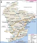
Tourism
Srikakulam is therefore a place that is worthy of visitation because of its attractive beaches and also its spirituality. Arasavalli Sun Temple: It is an old temple of Lord Suryanarayana (Sun God) which is found in Arasavalli at a distance of 3km from Srikakulam city by the Eastern Ganga dynasty rulers in the 7th century AD. It is one of the remaining few working Sun temples of India. The temple is constructed in such a way that the early morning sun can shine directly through the gateway twice a year for Uttarayan and Dakshinayan visits, and illuminate the feet of the central, granite, deity. Sri Kurmam Temple: It is 13 km away from Srikakulam town, is one of the only temples in the world where Lord Vishnu is offered in his Kurma (tortoise) form. The temple architecture itself is rather unique and the two flagpole structures (Dhwajastambhas) besides the beautiful medieval paintings and stone carvings of Kalinga and Dravidian style are a part of it. The temple is dedicated to Lord Shiva and the unique Shiva Lingam with a face (Mukhalingam) carved in the natural trunk of a tree. The complex is of great importance because of the excellent Kalinga style carvings and is termed an outdoor museum of medieval art.
Demographics
Srikakulam district is located in the state of India. According to the data provided by 2011, there are 27,03,114 people in the district of Srikakulam, and that considerably adds to the number of people in the state. In total, Srikakulam district is home to 13,41,738 men and 13,61,376 women. Speaking about the sex ratio in Srikakulam district, we should say that there are 1015 women per 1000 men, which is equal to or exceeds the national average. The indicator reveals the demographic condition and gender composition of the district. There have been changes in demographic composition in Srikakulam district during the census years. Thus, the literacy rate in Srikakulam district is 55.32% and it is the proof of education in the district. The literacy rate among males is 71.61%, while among females it is 52.08%, and the difference between the groups is 19.5%. Education plays an important role in the work of the district administration. Telugu (92.32%), followed by Odia (5.34%) and Savara (1.92%). Approx. 17% of the population lives in urban and semi-urban centers.
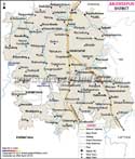
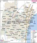
Administration
In terms of administration, the structure of Srikakulam ensures direct and decentralized administration along with an effective public service delivery mechanism. The District Collector heads Srikakulam with the help of administrative officers from various divisions.
Revenue Divisions: There are 3 Revenue Divisions in the district for effective administrative management:
- Srikakulam Division
- Tekkali Division
- Palasa Division
Mandal Administration: There are 30 mandals (tehsils) in Srikakulam, which are the basic points where the developmental and revenue activities take place.
| Facts of Srikakolam District | |
|---|---|
| Official Name | Srikakolam |
| Location | Andhra Pradesh |
| Area (km2) | 5837 |
| Population | 27,03,114(2011) |
| Language | Telugu, Odia, Savara |
FAQs
Q1: What is the number of Villages in Srikakolam District?
Beyond the edge of town, time settles into quieter beats - here in Srikakolam, 1868 villages dot the landscape across its administrative patches. Even when split by boundaries, every patch keeps close to open land and habitats passed through seasons. While oversight divides, roots grow deep where soil meets routine.
Q2: How many people live in Srikakolam district altogether?
27,03,114 folks show up in the headcount for Srikakolam district. Not estimates built on assumptions - these figures arrived at through actual counts run by government teams. Each individual appeared on official records drawn within the district's borders.
Q3: What is Srikakulam famous for?
Srikakulam boasts of having a unique cultural, spiritual, and artistic heritage in India. Aravalli Sun Temple: One of the rare surviving ancient temples devoted to the Sun God. Sri Kurmam Temple: The only temple in the world dedicated to Lord Vishnu’s Kurma Avatar. Ponduru Fine Khadi: Handmade khadi cotton fabric is the epitome of traditional Indian handlooms. Budithi Brassware: Rare metal arts made from special metal alloys. Palasa Cashews: Major center of processing and exporting cashew nuts.
Q4: Why is Ponduru khadi unique?
It is the only place in India where the weaving process uses a fish jaw bone (of Valuga) to clean the cotton. Hence, the quality of clothing made using this cloth is very good. Moreover, Mahatma Gandhi was a big fan and he always used it.
Q5: Does this district have a good bird-watching site?
Yes. Telineelapuram Bird Sanctuary is a place that one should visit.
Q6: Why was this district called "Chicacole"?
"Chicacole" is merely a corruption of the district's name by the British colonizers. This name was in use during the Madras Presidency days until independence.
Q7: What are the major industries in the district of Srikakulam ?
Pydibhimavaram is home to several pharmaceutical factories, Palasa is noted for its cashew processing and export industry.
Last Updated on : July 22, 2026