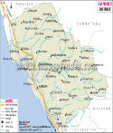
Kozhikode District Map |
|
||||||||||

|
||||||||||
|
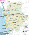
| *Map showing national highway, major roads, district headquarter, etc in Kozhikode District of Kerala. |
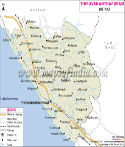
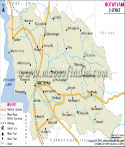
| Major Districts of Kerala |
 |
 |
 |
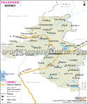 |
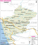
| Ernakulam District Map | Malappuram District Map | Kollam District Map | Palakkad District Map |
 |
 |
 |
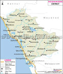 |
| Kannur District Map | Thiruvananthapuram District Map | Kottayam District Map | Kozhikode District Map |
| other districts of Kerala >> |
The places of interest in Kozhikode are-
Art Gallery and Krishna Menon Museum
Vadakara
Chaliyam
Kappad
Mananchira Square.
Places in Kodzikode District Map
Iringal, Mennanyam, Vadakara, Nadapuram Road, Edacheri, Kuttyadi, Palen, nadapuram, Kovilumpora, Valayam, Payyoli, Tikkodi, Pandalayini, Quilandi, Thiruvangoor, Elattur, West Hill, Kappad, Kozhikode, Beypore, Kadalundi, Ferokh, Kallai, Mavur, Kunnamangalam, Telekkod, Thamarassery, Kodancheri, Punnur, Kallanod, Lakkadi, Puddupadi, Kodancheri
Last Updated on : May 11, 2026