






About
NTR district is one of the youngest districts of Andhra Pradesh and the drama unfolding is a master stroke as grand as a film epic set in fertile land, bustling towns and hallowed river banks. The district's got its name through the legendary actor, film maker and Andhra Pradesh's former Chief Minister, Nandamuri Taraka Rama Rao (NTR), who has a legacy interwoven in Telugu people's pride, culture and political history. Also, it was formed on 4 April 2022.
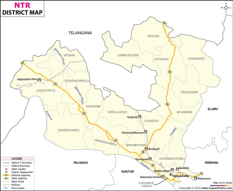
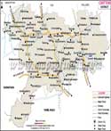
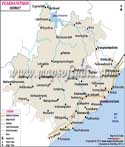
The district is spread over an area of around 1,532 km² and a major portion of the Andhra Pradesh Capital Region. Vijayawada is a commercial hub of Andhra Pradesh, known as the commerce centre and is the district's heart. In the NTR district map, some key towns, e.g., Tiruvuru, Nandigama, Jaggaiahpet and Mylavaram with their distinct economic and cultural quotient are marked.
History & Culture
The area has been an integral part of ancient kingdoms that prospered along the banks of the Krishna long before the establishment of modern administrative unit boundaries. For millennia, the river basin was an attractive place for settlement, trade, rulers and spiritual leaders. The area has been influenced by different dynasties including the Satavahanas, Ikshvakas, Eastern Chalukyas and Vijayanagars, etc., as per the archaeologically found evidence.
In medieval times, throughout the area one could find temples, trading centres and agricultural communities. European trading interests and British rule came and changed the economic and governmental life of the community. After being established as a vital transport and transit hub, Vijayawada slowly built up to become an important urban node.
The district came into the limelight in a new sense with the naming process of the district after N.T. Rama Rao. He is a political leader who changed the course of the Telugu community and is also regarded as a film star. The name of the district is just a reminder of his contributions in society, culture and governance.
The culture here is very colourful and rich. The language spoken is the dominant one(Telugu) and the traditional culture still influences their daily lives. The towns and villages become great stages in the religious festivals, lit up by devotion and celebration.
The day of Sankranti is celebrated with colourful designs of rangoli, decorated cows and merriments. Ways of renewal and prosperity are observed during the celebration of Ugadi, the Telugu New Year. The events of Dasara and Deepavali fill different communities with processions, lights and culture.
The district map of NTR highlights various sites which are religious and cultural monuments that have been present in this area for a long time. Traditional theatre performances and Kuchipudi dances are still very much a part of the cultural landscape, and are traditionally listened to along with classical music. The literary heritage is also well established as the district has a strong link with the Telugu language and arts.
Local identity is also in terms of cuisine. Rich Andhra foods are of a long origin and over the years, they have developed into a spicy food variety with pickles and sweets. Traditional food is as memorable as the monuments in the town.
The NTR district map also shows the cultural diversity of both rural and urban communities. The closeness of modernity and ancient tradition in educational institutions, in the confines of supermarkets, in the movies, in lives governed by technology, shows an epic transition.
Economy
The economy of the NTR district works on the principle of a large and complex production with many interdependent production sectors that help the district's economy to maintain growth and prosperity.
Proximity to the administrative set up of Andhra Pradesh puts the government sector in a key position. Vijayawada is also a major administrative centre with multiple regional and district administrative offices. The government departments create significant jobs and provide region-wide administrative services.
Infrastructure (development projects), urban planning and urban development, transport infrastructure and public welfare projects play an important role in economic activity. The NTR district map illustrates the effect of administrative institutions on the growth in the district.
Government-funded educational and healthcare institutions are also an important part. Schools, colleges, hospitals and public service organisations offer jobs and enhance social development indicators.
Public sector enterprises play a role in building industry and infrastructure. Electricity distribution, irrigation management, transport services and public utilities are also vital parts of the economic infrastructure of the district.
The NTR district map is colourful to show locations where public infrastructure projects have helped speed urbanisation and industrial growth. In addition, the public sector banks and financial institutions help businesses, provide agricultural loans to farmers and farmer enterprises and provide loans for entrepreneurs.
Services are by far the predominant element in the district economy. It is a major trading centre, with traders and retailers from all over the country, educational institutes, healthcare units and financial service institutions making a foray in the city.
Education is yet another significant economic sector. There are several universities, colleges and professional colleges which brings student from various parts of Andhra Pradesh and other states.
There has been a significant increase in the number of health services and the hospitals and specialised medical centres have all grown to serve huge numbers. Growth is fairly consistent in information technology, banking, insurance and hospitality sectors.
The NTR district map shows a greater convergence of businesses around Vijayawada and the gradual growth in economic possibilities in the nearby towns. The NTR district map also shows how the transport infrastructure is supporting agriculture & industry creating a dynamic economy.
Tourism
NTR district showcases tourism in a manner similar to a thrilling climatic scenery, a history trip in addition to a study trip in engineering achievements and natural beauty.
The Kanaka Durga Temple is one of the most well-known sites to visit. The temple is located on Indrakeeladri Hill overlooking the Krishna River and is one of the most popular temples in the city. Dasara is an extremely festive time of the year. This is the NTR district map, prominently featuring this sacred landmark which symbolises the spiritual significance of the NTR district.
Prakasam Barrage is a gorgeous spectacle of the river Krishna. The barrage is also a significant engineering achievement and is a picturesque site and superb to view especially on a darker evening with the lights on that create an amazing display.
The beautiful rock-carved architecture of Undavalli Caves, which are located near Vijayawada, is worth seeing. Remarkable sculptures and historical significance are contained in these ancient caves attracting historians, travellers, etc.
The Kondapalli Fort is a testimony to medieval military architecture. The fort is a prime example of classic architecture and provides a great view and history of local power plays. Kondapalli village nearby is also renowned for their traditional wooden toys made by skilled artists. Kondapalli is a cultural and historical landmark as indicated on the NTR district map.
Another significant ancient archaeological site in Mogalrajapuram is the ancient rock-cut shrines and sculptures of Mogalrajapuram. They play an important role in developing the art value of the district and its popular tourist and heritage attractions.
Further from the NTR district map, there are a number of temples, riverfront places and cultural centres which are in the process of providing a diverse form of tourism in the region. The nature, spirituality, history and urban attractions seem to blend in here. Each and every location is a chapter that enriches the district's constantly evolving story.
Demographics
The population roughly calculated as per the 2011 Census figures in the areas that now cover the NTR district, is roughly about 22 lakh. Since then, there has been regular population growth and urban development in general around the city of Vijayawada.
As referred, the literacy rate of the district is about 81%, better than the other districts of Andhra Pradesh. Schools have contributed importantly to the high levels of literacy and human development indicators.
The district's main language is Telugu. The education, administration and business widely use the English language. Many of the people, especially in urban areas, also understand Hindi. This map of the NTR district shows the impact of urban corridors on the growth of settlement in the area.
Administration
NTR district has a well-defined administrative structure that ensures effective governance, service delivery and accountability to the public. The district is divided into three revenue divisions – one at Vijayawada and the others at Nandigama and Tiruvuru.
An examination of the NTR district map makes it clear that the administrative linkage between the urban centres is to rural areas. According to the government records, there are around 415 villages in the district. The villages play an effective role in the agricultural production and also in their traditions and rural development.
These administrative departments are related to fields of education, health care, agriculture, revenue and infrastructure development and welfare programmes. Digital governance tools have also greatly enhanced service provision and citizen engagement.
The NTR district map is very important for reference for administrative purposes, which helps the planning authorities, development agencies and public institutions. The district is dedicated to economic development while maintaining good governance as development spreads into the district, and it remains ambitious to keep its goal in sight.
The NTR district map also indicates that the strategic position of the district is within the overall development vision of Andhra Pradesh. From the developmental point of view, from the cultural and economic, the district gradually continues to develop and maintain its unique traits. The map graphically illustrates a district where the holistic narrative of history, progress, and aspiration is understood.
FAQs
Q1: What is the headquarters of NTR district?
Vijayawada is its headquarters.
Q2: When was NTR district formed?
It was formed in 2022.
Q3: What is the approximate population of NTR district?
Its population is around 22 lakh.
Q4: How many villages are in NTR district?
It has about 415 villages.
Q5: Which river flows through the district?
The Krishna River flows here.
Q6: What language is mainly spoken in the district?
Telugu is the main language.
Q7: What is NTR district famous for?
It is famous for Vijayawada.
Last Updated on : July 24, 2026
