Parvathipuram Manyam District Map


District Map of Parvathipuram Manyam

Click here for Customized Maps arrow custom map
District Map of Parvathipuram Manyam
Custom map available for purchase, showcasing unique designs tailored to individual preferences and locations
*Parvathipuram Manyam District Map highlights the National Highway, Major Roads, District Headquarter, etc in Parvathipuram Manyam.
  Major Districts of Andhra Pradesh  
Anantpur District Map Guntur District Map East Godavari District Map Chittoor District Map
Anantpur District MapGuntur District MapEast Godavari District MapChittoor District Map
    
Prakasam District Map Krishna District Map Kurnool District Map Vishakhapatnam District Map
Prakasam District MapKrishna District MapKurnool District MapVishakhapatnam District Map
 
  Other Districts of Andhra Pradesh >>

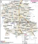
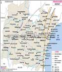
The Indian state of Andhra Pradesh has a district known as Manyam. It started operating on April 4, 2022, with Parvathipuram serving as its administrative centre. The Andhra Pradesh government has released the final notice. It is now one of the state's twenty-six resulting districts. The Parvathipuram revenue unit of the Vizianagaram district and a portion of the Palakonda revenue unit of the Srikakulam district combine to form the district.

This neighbourhood is situated between Eastern longitude 83.4 and Northern latitude 18.8.

This district is bordered to the north by the Koraput district of the state of Odisha, while it is encircled to the south by the districts of Vizianagaram and Srikakulam, as well as the districts of Alluri Sitharama Raju to the west and Rayagada to the east.


Last Updated on : March 13, 2026