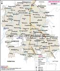
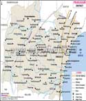
The district of Srikakulm is located in
Andhra Pradesh, a southern state of India. Srikakulam used to be a part of Kalinga kingdom in ancient India.
A considerable part of this district is occupied by forests. In the east flows the Bay of Bengal. Vamshadhara, Tanaya, Nagavali and Mahendra are the four main rivers of this place.
Srikakulam is chiefly inhabited by tribal people. The main economic resources are timber, bamboo, manganese, mica , graphite are obtained from this place
Jute constitutes the most important form of industry. Srikakulum is the land of temples. The Arasavally sun temple, the Srikurman Vishnu temple famous for its architecture and the Srimukhalingam temple deserves special mention other places of tourist interest are Baruva and Kaviti which may be visited for their scenic beauty.
Educatonal institutes in Srikakulum are both government run and private .The small district houses several degree and post graduate collages and engineering and medical collages. There are other important educational institutions like law collages, nursing collages, B.Ed collages and distance education collages and M.B.A collages.
Srikakulam is well connected by roads and Visakhapatnam airport.
Last Updated on : May 11, 2026