






About
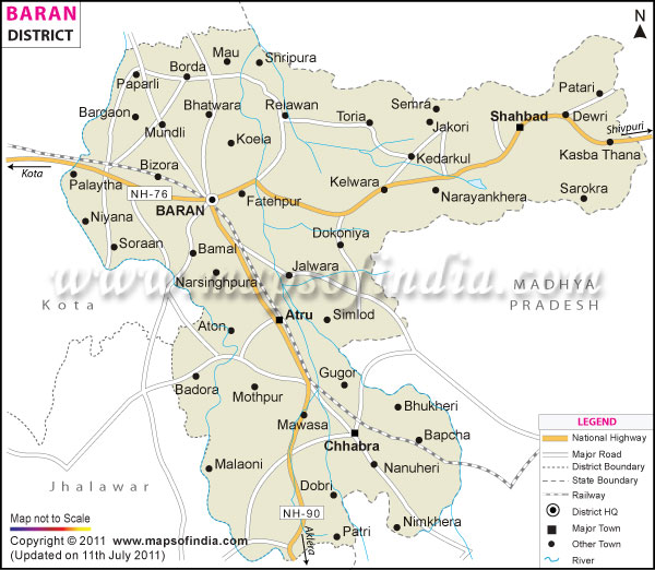
Baran lies in southeastern Rajasthan, within Hadoti, a stretch humming with old-world energy. Not many expect greenery here, yet mist rises off crop-heavy soil each morning. Rolling hills fold into thick forest, breaking only where flatlands take over. Neighbors include Kota and Jhalawar, while across one edge runs Madhya Pradesh. Locals trace the name back to Barah Gaon - a nod to how twelve hamlets once merged under one sky. Twelve became one; that story still roots people today.
Spreading across almost 7,000 square kilometers, Baran enjoys remarkable natural advantages. Flowing throughout the year, the Parbati and Kalisindh rivers cut paths through its landscape, depositing fertile black earth - this richness fuels strong farming output here. At the center stands Baran town, bustling with administrative activity.
History & Culture
Baran's past unfolds through layers of old forts, clan traditions, and changing rules. Once woven into the Maurya and Gupta realms, it eventually passed to Khichi Chouhan Rajput chiefs. Under medieval shifts, strongholds like Shahbad and Shergarh gained military weight. Rising atop a stony spine during the 1500s, Shahbad Fort stood as a key bastion across Hadoti - later seized by Shershah Suri. Over time, governance flowed into the hands of Kota’s royal domain. Baran took shape as its own district on April 10, 1991, pulled from Kota to improve governance and support growth nearby. Before that date, it belonged to the Kota district after India became independent. Earlier still, the Jhala Rajputs shaped life across the area, guiding both commerce and protection of pathways through their rule.
Perched between regions, Baran carries echoes of both Hadoti roots and Malwa flavors drifting in from nearby Madhya Pradesh. Spoken life here moves mostly through Hadoti - a Rajasthani variant - alongside the wider reach of Hindi. Shaping much of its character are indigenous communities, especially the Sahariya people, long settled in these wooded tracts. Their presence pulses through rituals rooted in nature worship, handed quietly from one generation to the next. Songs rise at dusk, dances follow ancient rhythms, all preserved without leaning on outside forms.
Festivals here pulse with shared excitement, each event drawing people together through rhythm and ritual. Beyond well-known occasions such as Diwali, Holi, and Dussehra, smaller villages host vast gatherings that shape regional identity. Beginning just after Jalazulni Gyaras, the Dol Mela unfolds across multiple days in Baran, where ornate swings - carrying images of village gods - are paraded down to riverbanks. Music swells around these processions: drumbeats guide dancers while singers call out old tunes passed between generations. At Kapil Dhara, another key moment emerges when members of the Sahariya tribe converge near a spring-fed cascade that appears only at certain times of year. There, customs rooted deep in oral history unfold slowly under open skies - rituals unfold beside stories told aloud by elders, matches arranged quietly among families.
Economy
Baran’s economy stands on strong farming output, which forms the core of local income. Though agriculture leads, government jobs add stability, bringing consistent wage flows into households. Growth in services follows closely behind, often tied to turning crops into marketable goods. Power production also plays a role, feeding both industry and nearby regions. Each part connects - not always smoothly - yet shapes how money moves across towns and villages.
Government Sector
Baran’s dense woodlands mean forest-based agencies operate extensively here. State institutions offer steady jobs, shaping economic life for many residents. Running services in remote areas demands numerous staff across different departments. Not just the courts or town councils, but also administrative offices need constant manpower. Where trees dominate the landscape, initiatives led by forestry corporations gain importance. These bodies oversee the gathering of natural goods from woods, besides aiding marginalized groups. Among those supported, members of the Sahariya tribe find key assistance through focused schemes. Beyond forests, classrooms, and clinics form another pillar of state involvement. Schools run by authorities, training institutes, and medical centers employ a notable share of workers. Employment flows not only from land management, but also from social infrastructure roles.
Public Sector
Despite its rural character, Baran hosts significant government-led initiatives shaping economic activity. One such initiative centers on energy production at the Chhabra Thermal Power Station, operated by the Rajasthan Rajya Vidyut Utpadan Nigam and serving as a core coal-based facility in the region. Employment trends have shifted gradually due to growth here, offering roles across engineering, maintenance, and temporary work contracts. Meanwhile, farming relies heavily on canal systems maintained by state irrigation bodies. These channels draw from dam projects, including Bilas and Parbati, delivering essential water flows where agriculture demands consistent input. Infrastructure planning in these sectors reflects long-term public investment patterns.
Services Sector
Baran's service economy has surged forward lately, thanks mainly to expanding cities, stronger farm incomes, and increasing trade flows. In places like Baran city, Anta, and Chhabra, shops and bulk sellers take up most space - moving products in and out of nearby countryside zones. Banking activity now plays a bigger role, supported by government-backed and member-owned institutions offering farmers loans, harvest protection plans, and startup funding.
Tourism
Hidden among Rajasthan's lesser-known corners, Baran unfolds slowly - ruined ramparts rise beside quiet forests, while time-worn shrines emerge from rocky outcrops.
Ramgarh Bhand Devra Temple
Some 40 kilometers from Baran lies the Bhand Devra Temple, a structure admired for its intricate design and sometimes called the "Mini Khajuraho of Rajasthan." Constructed during the 10th century CE beside a modest pond, it honors Lord Shiva through form and function. Its architecture reflects the well-known Khajuraho tradition, though set apart by location and context. Found within the rare curve of the Ramgarh Crater - a geological scar left by a meteor - its setting feels almost accidental, yet striking.
Carved into the stone walls appear gods, sky-bound dancers, creatures both real and imagined, each shaped with care. While time has worn parts down, fragments still whisper depth and age. Visitors arrive not just out of curiosity but pulled by something quieter - an atmosphere older than memory.
Shahbad Fort
High above wooded slopes and wild ravines, Shahbad Fort rises as a powerful relic of southern Rajasthan's past. Constructed around the 1500s under a Chauhan king, its presence dominates the skyline with thick ramparts, tall guard posts, along rising doors reinforced with metal. Within its bounds lie broken halls once used as royal chambers, ancient water structures carved into stone, while an older mosque stands shaped by Mughal design.
Shergarh Fort and Sanctuary
Perched beside the Parbati River, Shergarh Fort stands as an old fortress given its current name by Shershah Suri amid regional conquests. Adjacent to it spreads the Shergarh Wildlife Sanctuary - home to dense seasonal woodlands where creatures such as leopards, sloth bears, wild pigs, large deer known as sambar, and slender antelope called chinkara find shelter. This pairing of historic structure and living wilderness draws quiet interest without fanfare.
Kapil Dhara
Away from busy roads, Kapil Dhara hides within thick green cover across rugged terrain. Down a sharp drop, water tumbles only when rain arrives, filling a stony basin beneath. This place carries weight - named long ago for Kapil Muni, a seer of old tales. Pilgrims come in steady streams, drawn by faith more than comfort. Among them, the Sahariya people find meaning during visits, washing in cool flows to honor those gone before.
Demographics
Baran district hosts a population on a slow but steady rise, shaped by varied social layers where village traditions meet emerging town economies. Official figures from the 2011 Census place its total inhabitants at 1,222,755. Of these, men make up 636,526 individuals; women number 586,229. For every thousand males, there are 921 females - a figure nearly matching Rajasthan's broader pattern at the time. Life here still leans heavily toward countryside settings: more than seven out of ten people dwell in farming communities or small tribal settlements.
Town areas hold the rest - just under one-quarter of residents are spread among key urban hubs.
Baran district's literacy level reaches 66.66%, based on full census data collection methods. Though males show higher engagement - measured at 79.94% - females trail behind with only 52.28% counted as literate. Since earlier records, government-backed learning drives, rural education paths for girls, and community development grants have helped shift these numbers upward slowly.
Beginning with speech patterns, Hadoti pulses through daily life here, a regional form of Rajasthani spoken alongside Hindi. Nestled near Madhya Pradesh, the area absorbs phrases and inflections from Malvi, shaping how people sound when they talk. Though rooted in tradition, voices shift subtly due to this quiet fusion at the state edge. Most residents identify as Hindu, about 92.65 percent, found across villages and towns. Following behind, Muslims account for roughly 6.55 percent of locals. Other beliefs appear too - Sikhs, Jains, and Christians - in smaller numbers that still matter. Notably, tribal groups make up a larger share than elsewhere. Among them, the Sahariya stand out as key contributors to identity and custom.
Administration
Baran district belongs to the Kota division within Rajasthan's administrative framework.
Close collaboration exists between the DM and the Superintendent of Police (SP), ensuring stability stretches through towns as well as villages. Law enforcement efforts gain direction through this joint administrative effort.
Baran district splits into eight administrative tehsils, shaped by the need to manage income flow and services across uneven land. Under each one works a Tehsildar, guiding daily operations from within. Running things locally allows responses that match what the area actually needs. Oversight stays close to people, not distant offices. The setup adjusts to landscape shifts without losing consistency. Local leadership forms the base of how tasks get done here. Structure follows function, quietly, across hills and villages alike.
South of the region lies Chhabra Tehsil, functioning as a key hub for industry. Its landscape is shaped by ongoing production activity. A prominent thermal power plant stands central to its identity. This area thrives on energy generation, influencing local development patterns. Infrastructure here evolved around industrial demands. Economic rhythms closely tied to operational output.
Because of deep-rooted techniques passed down through families, local looms shape much of the economy. Though modern methods emerge, older ways still hold a strong influence across workshops. Where machines appear, they often work alongside human hands rather than replace them.
| Official Name | Baran |
| Location | Rajasthan |
| Area | 6991 sq. km |
| Population | 1222755 |
| Language | Hindi |
FAQs
Q1: How many villages are there altogether in Baran district?
There are around 1130 villages in the district.
Q2: What is the population of the district?
1222755 people live in the district according to the 2011 census.
Q3: What is the district of Baran most famous for?
The district is famous for large production of coriander and soybean. This makes it a major agricultural hub in Rajasthan. The 10th century Ramgarh Bhand Devra Temple is also famous among tourists. Apart from this, the Shahbad Fort, Chhabra Thermal Power Station, and the cultural heritage of the Sahariya tribe.
Last Updated on : July 17, 2026
