

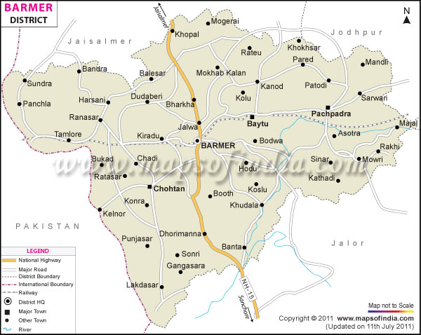





About
Hidden at the edge of Rajasthan's sweeping desert landscape lies Barmer, a region shaped by arid winds and ancient paths. Its vast stretches claim space among the biggest divisions within the state, pressed close against Pakistan along its western rim. Northward spreads Jaisalmer; to the east stand Jodhpur and Pali, while Jalore marks the southern reach - land that slopes gently toward salty plains near Kutch. A legacy etched in history begins with Rawat Bahadur Rao, sometimes known as Bar Rao, who built life here centuries ago under the Parmar dynasty. What once bore the name Bahadamer - the stronghold linked to Bahada - shifted slowly through years into today’s simpler sound: Barmer. Spreading across nearly 28,387 square kilometers, this area reveals textbook desert scenery - endless dunes sculpted by wind, wide stretches of stony ground, and rugged outcrops carved by time.
History and Culture
Hidden within Barmer’s past are fierce Rajput lineages - especially the Parmars and Bhatis - who clashed across generations for dominance in this arid land. Long before any city rose here, the region carried the name Mallani, still echoed now in its proud, swift horseblood lines. A turning point came once Rawat Bahada Rao raised walls atop a stony ridge, guarding crossroads vital to commerce linking Mewar with Sindh.
Under the vast desert sky, daily life in Barmer moves with seasonal shifts, shaped by centuries-old customs. Bright hues stand out across beige dunes, marking celebrations woven into everyday existence. Among these people are skilled performers - Manganiyars and Langas - who guard ancestral melodies sung through time. From father to son, mother to daughter, music flows without pause, carrying on strings of the kamayacha and sharp beats of the khartal.
Tales unfold in voice: wars long past, lovers lost, skies turning dry or kind. Craftsmanship holds equal ground here, rooted as deep as song. Stalls brim with handmade wonders - Ajrakh cloth stamped in precise patterns, fabrics glittering with tiny mirrors stitched by hand, carpets knotted slowly over weeks, woodwork carved with steady fingers trained from youth. Each piece bears marks of patience passed quietly between kin.
Held each year, the Desert Festival turns into a full-scale village celebration. Across towns and villages, people gather when the Thar Mahotsav kicks off - think camel races thundering across sand dunes, spins of the Kalbelia dance under open skies, plus contests where men wrap turbans in ancient styles, pulling in visitors far and wide. Not far behind comes the Tilwara Cattle Fair, rooted deep in tradition along the cracked riverbed of the Luni. This market has stood through generations, tracing its name back to Rawat Mallinath, a revered figure of local tales. Families trek in from distant desert outposts, reuniting beside pens filled with camels, horses, herds of cattle; talk flows freely while deals unfold slowly beneath dusty suns.
Economy
Deep beneath the sands, shifts began long before most noticed. Life once moved with seasons, shaped by crops that depended on scattered rains. Herds wandered where grass survived, following ancient paths across dry land. Then came drilling rigs, rising like metal shrubs in open fields. Wealth hidden below ground started reshaping daily routines above it. Work now often means uniforms instead of plows. Machines hum where goats used to bleat. Growth arrived without warning, altering old rhythms. This corner of Rajasthan breathes differently these days.
Government Sector
Stability comes through government roles, offering consistent incomes across many households in the area. Running offices, handling property disputes, supporting community well-being - each task pulls in workers from nearby towns. Positioned along a frontier, Barmer hosts long-term military units including army detachments and BSF contingents. Their ongoing operations feed into regional markets, boosting services tied to movement, storage, and material supply. When monsoon patterns shift and farming suffers, national job schemes step in, ensuring village economies do not fully stall.
Public Sector
Heavy infrastructure and major energy efforts shaping Barmer come mainly from government-led initiatives. Thermal plants operated by state firms - such as those in Kapurdi and Jalipa - convert nearby lignite deposits into electric power. Oil extraction sites including Mangala, Bhagyam, and Aishwarya are developed through collaboration between public agencies and corporate entities. At Pachpadra, one of India’s largest upcoming refineries rises slowly - a joint effort expected to shift regional industry patterns. Transportation across long stretches of arid land relies heavily on railway routes managed by Indian Railways along with buses run by RSRTC.
Services Sector
Barmer's economy now leans heavily on service-based work, fueled by activity in oil and mineral extraction. Branches of national and privately owned banks have spread through the area, offering credit to construction firms, maritime operators, or retail outlets. Growth in lodging and property development has kept pace, driven by steady need for updated hotels, business spaces, or residences in Barmer and surrounding Balotra. As wealth moves into local hands, education providers, skill-building institutes, repair garages, plus medical facilities run without government backing now appear frequently throughout the zone.
Tourism
Out here, Barmer strips things down - ancient buildings rise quietly under open skies. Travelers drawn to heritage often find it by chance, stumbling upon rhythms unchanged for generations. Where others flock, this place stays still. Folk songs echo where footprints fade fast in sand. History does not perform; it simply remains.
Kiradu Temples
Far from crowds, tucked into arid land near a major urban center, rest the remains of ancient worship sites known as the Kiradu Temples. Located roughly thirty-five kilometers out, these five shrines rise from sand and silence, shaped by artisans during the eleventh and twelfth centuries. Crafted in the ornate manner of the Solanki tradition, their walls carry stories etched in stone. Referred to sometimes as Rajasthan's answer to Khajuraho, they draw attention through finely cut figures, towering columns, and art worn slightly by time. Among them, the Someshwara Temple stands tallest - least damaged, most whole - revealing how creativity thrived even in harsh, sunbaked regions long ago.
Barmer Garh (Fort)
From the pavement of today’s town, eyes lift toward the aged Barmer Fort perched atop a stony ridge. Rising in the 1200s under Rawat Bahada Rao, centuries have worn parts away - yet shrines remain, along with weathered stone yards where footsteps echo. As daylight fades, travelers arrive by foot, drawn not by crowds but quiet space, where rooftops stretch wide beneath sinking light, merging slowly with desert flatness beyond sight.
Nakoda Jain Temple
Perched close to Mewanagar within the Balotra region, the Shri Nakoda Jain Temple stands as a serene destination for pilgrims across India. Revered for housing an idol of Lord Parshvanath, its architecture shines through smooth white marble and balanced design. Though surrounded by steep rocky terrain, the site feels removed from noise, almost untouched. Industrial zones lie just beyond view - yet here, stillness takes hold without effort.
Pachpadra Salt Lake
White salt stretches far under open skies - this place draws eyes. Harvested here long before modern maps, its purity remains notable. A vast mirror forms when rain pools slightly, reflecting clouds and light in odd ways. Travelers pause often, drawn by silence more than scenery. Winter dries the ground fully, revealing crisp textures across the surface. Photographs capture what words miss: depth without shadows, brightness without glare.
Demographics
Barmer's residents occupy a wide-open, strikingly empty terrain where city life creeps in gradually. The 2011 Census recorded its full population at 2,603,751 individuals. Among them, male figures reach 1,369,022 compared to female counts of 1,234,729 - this leads to a gender balance of 902 women per thousand men. Though better than past records show, such data still hints at deeper regional struggles seen through northwest India. Most inhabitants remain rooted in countryside settings; roughly 93 percent reside in scattered arid settlements or follow herds seasonally. Town centers hold just around 7 percent by contrast.
Out in the open, people speak Rajasthani - most often the Marwari form - with Hindi also common in daily talk. Near boundary areas, voices shift into regional variations such as Dhatki and Thali, tongues tied closely to those used across the line in Sindh. Most follow Hindu traditions, making up roughly 86.20 percent of residents. Muslims form a significant presence too, standing at nearly 12.40 percent. Tightly bonded Jain households appear throughout, joined by scattered Sikh and Christian clusters that shape the area’s makeup.
Administration
Located in western Rajasthan, Barmer falls under the jurisdiction of the Jodhpur division. Oversight of daily administration rests with the District Collector and District Magistrate. Revenue collection forms a core duty held by this official. Alongside law enforcement efforts, coordination occurs between the DM and the Superintendent of Police. Maintaining public order remains a shared objective shaped through their joint presence. Regional stability depends on consistent cooperation at these levels.
Across its vast expanse, Barmer splits into 17 tehsils so governance stays functional. Administration at the local level manages land documents along with civic needs in each zone. Key divisions among them are: Located at the heart of the district, Barmer Tehsil hosts key government offices and serves as the primary center for local administration.
Built around fabric production, Balotra Tehsil handles the rhythm of nearby mill settlements. With machinery humming through the day, it supports clusters of workshops and spinning units. Instead of slow growth, its pace matches factory shifts and supply timelines. Though quiet on the surface, activity pulses behind warehouse gates. From cotton bales to woven output, movement defines much of daily work here.
Besides overseeing land matters, Baytoo Tehsil manages administrative functions tied to oil and gas operations. While focused on resource zones, it acts as a core hub for regional coordination. Its role emerges clearly in managing territory linked to extraction activities. Not limited to paperwork, the tehsil supports field logistics through structured oversight. From planning to execution, governance here shapes how energy projects move forward. Often operating behind the scenes, it ensures alignment between local needs and industrial demands.
Across the dusty expanse of Barmer, about 2,160 revenue villages form the core of daily life. Though isolated, each one operates under the Panchayati Raj framework, shaped by villagers choosing their own leaders. Far from the main hubs, places like Shiv, Siwana, Ramsar, and Sindhari keep public support flowing into remote desert zones. Government aid moves steadily through these areas despite harsh terrain. Remote outposts rely on such tehsils to maintain access. Without them, isolation would block basic services. These nodes act quietly but hold steady across empty stretches.
| Facts of Barmer District | |
|---|---|
| State | Rajasthan |
| District | Barmer |
| District HQ | Barmer |
| Population (2011) | 2,603,751 |
| Growth | 32.52% |
| Sex Ratio | 902 |
| Literacy | 56.53 |
| Area (km2) | 28387 |
| Density (/km2) | 92 |
| Tehsils | Barmer, Baytoo, Chohtan, Gudha Malani, Pachpadra, Ramsar, Sheo, Siwana |
| Lok Sabha Constituencies | Barmer |
| Assembly Constituencies | Barmer, Baytoo, Chohtan, Gudamalani, Pachpadra, Sheo, Siwana |
| Languages | Rajasthani including Marwari, Hindi, English |
| Rivers | Luni |
| Lat-Long | 25.76032,71.429901 |
| Travel Destinations | Siwana fort, Asotra Temple, Kiradu Temple, Nakoda Temple, Viratra mata Temple, Mahabar Sand Dune etc. |
| Government Colleges/Universities | D.R.J. Government Girls College, Government College, Govt. College, M.B.C. Government Girls College, M.B.R. Government College etc. |
FAQs
Q1: How many villages are there altogether in Barmer district?
Besides its remote desert setting, Barmer hosts approximately 2,160 government-notified revenue villages. Though scattered widely, these communities rely on locally elected gram panchayats for basic services - water access stands alongside schooling and rural road maintenance in priority.
Q2: What is the population of the district?
2603751 people live in the district according to the 2011 census.
Q3: What is the district of Barmer most famous for?
Deep beneath Barmer’s desert surface lie vast oil reserves, fueling much of India’s homegrown power needs through extraction and processing. Lignite pits stretch across the region, pulling black gold from layers formed ages ago.
Last Updated on : June 22, 2026
