






About
Jhunjhunu district is a notable and prosperous district of Rajasthan. Its administrative headquarters is in the city, which serves as an education and commercial centre. Being steeped in history along with an abundance of Havelis, as well as a Military culture & entrepreneurial spirit, makes this district uniquely important within Rajasthan's cultural and economic contexts.
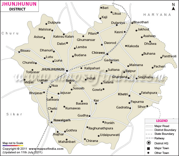
It has a district area of roughly 5928 sq kms, with Haryana to the north and bordering districts like Sikar and Churu in Rajasthan. The Jhunjhunu district map of Rajasthan highlights the importance of trade and transport as well cultural connection for this district which lies between two neighbouring states namely Rajasthan and Haryana. The Jhunjhunu district map also indicates that it is a multi-settled district from the ancient town Nawalgarh in the south to Mandawa and then to towns like Pilani on the northern side.
The district is one of Shekhawati, which is well known for its Haveli depicting fresco paintings and is termed as the “Open Art Gallery of Rajasthan”. The Jhunjhunu district map features many heritage towns, which are popular tourist places in India and abroad. The district has also earned a name for its contribution to the Indian Armed Forces, with a large number of soldiers of excellent calibre coming from the district.
Jhunjhunu district is a blend of the ancient and the modern today. The Jhunjhunu district map can be used as a tool for administration, or as a cultural destination—regardless, as each look is unique, the district is a special mixture of tradition and heritage, education and economic development.
History & Culture
There is an integrated history of the Jhunjhunu district with the history of Shekhawati. The name of the community, the Shekhawats and the name of the area are derived from Rao Shekha of the Rajput 15th century AD, who founded many principalities here. Over the years, these lands developed into bustling centres for business and culture.
It is believed that the name of Jhunjhunu town was named after the king or ruler of this area, who ruled at that time, i.e. Jujhar Singh Nehra (Popularly known as 'Jhunjha'). The region was ruled by Rajput rulers, local chieftains and the Mughals during medieval times. Shekhawat rulers constructed forts, palaces and settlements, which served as a foundation of the development process of this district. The Jhunjhunu district map helps understand the historic events in the region, which played a big role in politics and economic life.
The whole culture of the district is also influenced by the culture of Rajasthan, but the culture gives a unique touch to the culture of Shekhawati. A large population of folklore and folk dances, the clothing of people is in colour. There are several mindblowing festivals which are celebrated with great enthusiasm, like Diwali, Holi, Teej, Gangaur, Makar Sankranti, etc. Religious fairs, along with community events, continue helping to maintain and promote local traditions.
Language and folklore are other significant aspects for the people here. Hindi, a widely spoken language, is used in the region. Shekhawati is spoken in several parts of the rural area as their everyday language, and is a variant of Rajasthani. The district has a good tradition in their traditional crafts too, such as woodwork, cloth and decoration.
Economy
The economy in Jhunjhunu district is mixed with agriculture-based, mining-based, manufacturing, educational, trade and service-based. Its charismatic location and entrepreneurial history have been a major factor in its economic growth.
Government Sector
The government has an important contribution to make to the district's economy. There are also good opportunities for jobs in administrative services, schools, hospitals, police, and public welfare programmes. Schools, colleges, hospitals, and local administrative bodies are also important contributing factors to socio-economic development under the Government sponsorship.
Connectivity and quality of life in the district get a boost from roads, water supply system & rural development schemes. The administrative centres of the Jhunjhunu district map will help in access to public services and governance.
Public Sector
Mining and industrialisation have historically had their influence on the public sector. Khetri is especially important on account of the Khetri Copper Complex, which is one of the largest copper mining and processing centres in India. The mining of copper has long been a concern of both current and former employment and economic output in the region.
The creation of jobs in the communities has been achieved through government-owned companies in the case of mining, energy and infrastructural projects. The contribution of these sectors is significant, as can also be seen with the help of the Jhunjhunu district map, particularly in the portion of the mining belt of Khetri, where the contribution of mining can be seen in economic growth.
Services Sector
The district's economy has become strongly supported by the services sector. The factors are paramount, huge and top-notch institutions such as BITS Pilani are luring students from far and near for offering education. Educational services provide jobs in the education sector, the hospitality sector and related activities.
Health services, banking, telecommunications, and retail trade/transportation are other important growth sectors. A Jhunjhunu district map reveals clustering of the service sector activities in urban centres like Jhunjhunu, Pilani, Chirawa and Nawalgarh.
Agriculture reflects a major share of the economic activity in the district. Cultivation of Bajra, Wheat, Mustard, Gram and Barley by farmers and animal husbandry also plays a large role in rural incomes. There are thousands of families engaged in dairy farming and the husbandry of different types of animals.
Tourism
The district of Jhunjhunu encompasses some of the most pleasing and beautiful heritage sites of Rajasthan. The famous tourist town of the district is most probably the town of Mandawa. The old fort, narrow streets and peculiar havelis, which are well designed with colors make the town famous. The amazing frescoes draw guests from all over the world to Shekhawati and render it an international tourist attraction.
Yet another highlight here is Nawalgarh, which is enveloped in its majestic mansions, museums, and its old architectural style. The district of Jhunjhunu has an architectural and artistic existence which can be referred to in the Jhunjhunu district map of the district as a major tourist destination.
Khetri Mahal in Jhunjhunu city is a strange seven-floor fortress made up of doors in large parts. The monument is one of the last truly great, unique monuments in both architectural and historical senses. Jhunjhunu, being the popular destination of Rajasthan, has a fine collection of temples, and Rani Sati Temple is one of the major Temples. Temple is a beautiful marble architecture which has been built on the foundation of centuries and has different shrines, with the main shrine of Rani Sati temple, which attracts thousands of visitors every year.
From the main places of interest, Pilani is best known for its renowned BITS Pilani, but a visit should be made to the Birla Museum and the Shiv Ganga complex. Educational tourism has taken considerable place in the identity of the town. The fort, which is named 'Dundlod Fort' and related havelis, will give an opportunity to the visitors to experience the architecture and heritage of the Rajputs. Considering the major chunk of the population, the town preserves the majority of traditional houses, which show the prosperity of the merchants belonging to the Shekhawati region.
Demographics
As per the reference drawn to the Census of India 2011, the number of people staying in the Jhunjhunu district is 2,137,045. Over the last few decades, the population trend that can be seen is constantly increasing by an unprecedented amount in this district, and it also constitutes one of the most populous districts of Rajasthan.
The District literacy rate was 74.13 per cent as compared to the State average of 66.11 per cent at that time. Improvements in education have been one of the significant accomplishments of the district.
Hindi is the official language and is used predominantly in administration, education and business. Shekhawati, the regional language of Rajasthan, is widely used in the rural and urban parts of the region. English is widely used in the educational and professional worlds.
There is a balance between the urban and rural population, and agriculture still plays an important role in supporting a significant proportion of people within the district. Better educational development, migration and entrepreneurship have helped to lead the socio-economic indicators as compared to many districts of the region.
Administration
Jhunjhunu district is headed by the headquarters of Jhunjhunu city. The district is part of the administration, whose governance is achieved via several district-level departments and local bodies of Rajasthan.
The district is divided into various Tehsils for administrative purposes, including Jhunjhunu, Buhana, Chirawa, Khetri, Nawalgarh and Udaipurwati. As part of the administrative reorganisation framework, additional units — centres below the tehsil level and subdivisions — have invariably been created and recognised to handle these basic civil administration entities with a governance reform agenda.
In the Administrative records for the Census 2011, the District has 927 villages. The life and even economy of the districts go through the back of these villages.
If the Jhunjhunu district map is used, the state task can become really efficient, and it would be easier to deploy field models of development planning. This will certainly help in planning governance, resource management, and infrastructure development in this place. Hence, mapping for growth well against the need basis concerning urban-rural distribution becomes very crucial.
FAQs
Q1: How many villages are there in Jhunjhunu district?
Jhunjhunu district has 927 villages according to the Census 2011 records.
Q2: What is the population of Jhunjhunu district?
The population of Jhunjhunu district was 2,137,045 as per the Census of India 2011.
Q3: What is the Jhunjhunu district famous for?
Jhunjhunu district is famous for its Shekhawati fresco-painted havelis, rich cultural heritage, military traditions, educational institutions such as BITS Pilani, and historic towns including Mandawa and Nawalgarh.
Last Updated on : July 17, 2026
