






About
The district is famous for its historical values and religious significance, educational and current values, and its growing economy. The district lies in the heart of the State and is also one of the major administrative hubs, a cultural and commercial hotspot of the State, with proximity to other states. Ajmer is also the cluster city of knowledge, as well as the headquarters of the district Ajmer, and is also well known for being a city of pilgrimage.
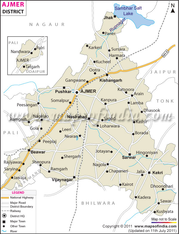
Almost 8,481 square kilometres of the district is in the middle of the Ancient Aravalli Hills. The district is enveloped by districts of Nagaur, Jaipur, Tonk, Bhilwara and Rajsamand, and there is Pali too. The district has been identified as a road transport hub for connecting to other parts of the state of Rajasthan. The license plate Ajmer map has gained recognition among travellers, researchers and students because of its comparatively easy use and geographical features and strategic location of the district.
History and Culture
The fact is that there are 1,000 years of history behind Ajmer. The name of the city originated from the seventh century ruler of Ajaypal chauhan that was named Ajmer. The city grew in importance during the eleventh century when the Chauhan dynasty reigned in the region, becoming an important medieval city of Ajmer. The kings of the area were more prominent, and Prithviraj Chauhan had a kingdom which influenced the history of northern India.
The Muslims regained power again in the aftermath of Prithviraj Chauhan's defeat in the 12th century, and Surain became part of the Delhi Sultanate again. Later, it became strategically and religiously important, and was recognised by the Mughal Empire as an important provincial centre of Ajmer. The emperor Akbar used to come there at times to pray at the tomb of Khawaja Moinuddin Chishti. The Mughals had Ajmer develop into an important administrative and military town.
The British then added the area to the province of Ajmer-Merwara (A in the map). Following Independence, it was also added to the administration of India for a short time before it was merged into Rajasthan in 1956. Change of Administrative Boundaries in a historical setting can be clearly understood by the Ajmer district map, which depicts the administrative changes in the district of Ajmer over time.
A combination of both Rajput and Mughal culture and Rajasthani culture can be seen in the culture of Ajmer. The district is renowned for its communal harmony where people of all faiths live, get together and enjoy each other's celebrations. Dargah Sharif is one of the very special cultural and religious festivals of the district, which is celebrated every year. Thousands have come to celebrate the martyrdom day of Khwaja Moinuddin Chishti.
The District has traditional folk songs, dances and handicrafts that are an integral part of the District's culture. The festive times are celebrated using Ghoomar and Kalbeliya dances. Local fairs and festivals, are held on Divali festival, Holi festival, Eid, Teej or Gangaur festival, are celebrated with enthusiasm. Cultural landmarks may stand as the hallmark of the district's culture, and in fact are featured on district maps, such as the Ajmer district map.
The district is also able to call on significant educational establishments. The Mayo College was founded in 1875 and continues to be one of the best boarding institutions in India. The educational tradition of the district of Ajmer has helped in establishing its name in the nation.
Economy
The District of Ajmer has a diverse Economy which includes Agriculture, manufacturing, trade, Tourism and Services. It is having its central location and good transport connectivity have contributed to growing it into an important economic centre of Rajasthan. The Ajmer district map showcases how fortunate the district is to be located on key road and rail routes.
Government Sector
The government makes a significant contribution to the economy of the district. There are also large employment opportunities provided by administrative offices, educational institutions, healthcare facilities and public services. Ajmer is the divisional head city, enabling the administration of the government, which is one of the key sectors providing employment and economic activity.
Government-sponsored educational institutions make their welcome contributions in terms of employment generation. Opportunities for teachers, administrators and support staff are available at public schools, colleges, universities and training centres. The government healthcare facility also has a big workforce.
Public Sector
The public sector dedicates resources to running the trains, improving railway infrastructure and providing services such as utilities. There had also been a connection with railway activities in Ajmer, and it is still an important railway centre in north-western India. A significant proportion of the population is employed by the railway workshops and associated businesses.
The growth in economic activities continues with the infrastructure projects for roads, water supply system and the urban development project. The Ajmer district map shows the public-sector activities and the transportation system that facilitates them both in urban and rural areas.
Services Sector
Services are among the major contributors to the economic activities within the district. Numerous jobs are available in tourism, hospitality, retail trade, banking, education and healthcare services. The sight of the presence of Dargah Sharif helps drive commercial activity during the year, bolstering hotels, catering establishments and transport operators along with local businesses. Another key service sector is education. Students come from across the country to institutions like Mayo College and other colleges. There has also been a visible growth, particularly with banking, insurance and financial services.
Agriculture nevertheless continues to be an integral part, especially in the countryside. The farmers grow wheat, barley, maize, gram, mustard, and some other crops. Besides animal husbandries, those that contribute to rural life are there, as well. Apart from various other documents, the Ajmer District Map is an agricultural planning document created to understand the land use and irrigation systems in the district.
The district is also recognised for the processing of Marbles and related industries, particularly around Kishangarh. The marble industry has made the area one of the most prominent areas for trading and processing of marbles in India. There are other small manufacturing units engaged in engineering products, handicrafts and textiles, which are also sustaining the local economy.
Tourism
The district Ajmer is one of the most visited districts of Rajasthan due to its religious, historical and natural phenomena. The Ajmer District map has been released for tourists who wish to tour the different areas of the district.
It is a very important pilgrimage place in India, due to its spiritual ambience and its architectural beauty. Ana Sagar Lake is another attraction of the place. Anaji Chauhan had constructed it around 1200 AD, when it was used as a lake to view the panoramic setting and to offer recreation facilities
Akbar's Palace and Museum are archiving the artefacts of the Mughals and the history of this region. The museum comprises valuable knowledge on the evolution of history of Ajmer. Districts of Pushkar itself are another celebrated centre of pilgrimage and one of the holiest in India. The town is renowned for the Pushkar Camel Fair, the internationally renowned Pushkar lake and Pushkar Brahma Temple. It is evident that the town of Pushkar is prominently mentioned on Ajmer District Tourism literature as the most loved tourist centre of the Ajmer district.
The site is scenic and is a recreational area for the Foy Sagar Lake. Nareli Jain Temple is a modern structure and has great significance and attractiveness for people visiting the temple as tourists. It is a large tourist hub of Rajasthan because of its mix of religious tourist destinations, historical tourist sites and natural heritage.
Demographics
According to the Census India, 2011, the population of Ajmer district was 2,583,052. The population of medium size and the proportion of urban and rural population are good in the district. An even distribution map of the Ajmer district remains a necessity for planners and researchers in the context of its population.
Based on the data from the 2011 census, the literacy rate of the district was 69.33 per cent. The literacy rate levels of males and females were 82.44 and 55.68 percent respectively. Through the district, literacy continues to be a contributor to the improvement of literacy as well.
The major language of the district is Hindi. The influence of the Rajasthani dialect is very prevalent in various sections; a notable example of such influence is found in Marwari and Dhundhari influences. Urdu is also widely spoken, particularly in the towns and cities in the district and by the district's minority communities. The district population is a blend of religious and cultural groups and adds to the diversity of the social fabric in the district. The Ajmer district map frequently gets used for demographic analysis for settlement patterns and the distribution of its population.
Administration
The administration of the Ajmer district is under the Government of Rajasthan. Led by a District Collector, a district is responsible for governance, development initiatives and state administration. The district has been divided into nine Tehsils, which are Ajmer, Beawar, Bhinay, Kekri, Kishangarh, Masuda, Nasirabad, peesangan and Sarwar. The Divisions are administrative entities which assist in the efficient administration of the District and the provision of Public Services. The Ajmer District Map is an asset for the administrators to manage the development activities or development projects in these villages.
In these big towns of urban areas, administration is carried out by the Municipal Corporation, such as in Kishangarh, Beawar and Nasirabad of Ajmer Municipal Corporation. The Ajmer district map will be of great use in the future in planning urban development, transport and public utilities.
| Facts of Ajmer District | |
|---|---|
| State | Rajasthan |
| District | Ajmer |
| District HQ | Ajmer |
| Population (2011) | 2,583,052 |
| Growth | 18.40% |
| Sex Ratio | 951 |
| Literacy | 69.33 |
| Area (km2) | 8481 |
| Density (/km2) | 305 |
| Tehsils | Ajmer, Beawar, Nasirabad, Masuda, Kekri, Kishangarh |
| Lok Sabha Constituencies | Ajmer, Rajsamand |
| Assembly Constituencies | Ajmer North, Ajmer South, Beawar, Kekri, Kishangarh, Masuda, Nasirabad, Pushkar |
| Languages | Hindi, Rajasthani including Marwari, Dhundhari |
| Rivers | Khari |
| Lat-Long | 26.175159,74.771347 |
| Travel Destinations | Pushkar, Khwaja Moinuddin Chishti Dargaha, Digambar Jain Temple, Salemabad (Nimbark Peeth), Taragarh Fort, Adhai - Din Ka- Jhonpra, Ana Sagar, Government Museum, Nareli Jain Temple etc. |
| Government Colleges/Universities | S.R.K.P. Government P.G.College, S.G.S.G. Government College, S.D. Government College, Govt. Girls College, Government Law College, Government P.G. College etc. |
FAQs
Q1: What is the total number of villages in Ajmer district?
Ajmer district has approximately 1,110 villages distributed across its nine tehsils.
Q2: What is the population of Ajmer district?
According to the Census of India 2011, the population of Ajmer district was 2,583,052 people.
Q3: What is the Ajmer district famous for?
Ajmer district is famous for the Dargah Sharif of Khwaja Moinuddin Chishti, Pushkar, its rich historical heritage, educational institutions and thriving marble industry.
Last Updated on : June 22, 2026
