






About
East of Rajasthan, Bharatpur stands where desert meets farmland. Not just the location gives it weight - centuries shaped its role. From the north and east, armies once moved, yet found passage blocked here. Rulers held power behind this line, safe because frontier defenses held firm. Land changed beyond this point - rocky hills gave way to flat green stretches leading into Uttar Pradesh. Gateways do more than mark places; they shape histories. That truth fits Bharatpur well. Nowadays, Bharatpur ties old grandeur to new growth in quiet rhythm. Serving as a key center for governance, it also feeds the region through rich farmland. Ecological travelers arrive often, drawn by the famed Keoladeo National Park. Its mix of duties gives the city layers few notice at first glance.
History and Culture
Built on battles and farming grit, Bharatpur's past hums with layered lives. Though myths whisper that its soil belonged to the Matsya realm during Mahabharata times - echoes of Vedic roots lingering - its true frame emerged through fierce will. Shaped not by chance but resolve, the Sinsinwar Jats, warriors among farmers, gave it form. Bharatpur breathes stories shaped by Braj Bhoomi, where tales of Krishna unfold through song and memory. Around here, tradition flows not just from Rajasthan but blends quietly with rhythms older than stone walls. Life moves to patterns passed down, seen in gestures more than grand displays. Colors on walls often whisper what words leave unsaid - echoing rituals both familiar and distinct. Even meals carry traces of a heritage that dances between regions without choosing one. Bursting onto village stages, Raslila brings stories of Krishna to life through dramatic dance and song. Meanwhile, crowds gather around Nautanki, where bold voices mix epic tales with biting wit in open-air shows. Even local fairs pulse with a spirit hard to ignore. Celebrations unfold without pause, shaped by tradition yet always lively. Out here, just before Holi hits, folks gather for the Brij Festival - rooted in devotion to Lord Krishna. Streets burst alive - not with quiet, but with dancing feet and voices raised in old melodies. Color flies through the air where laughter follows. Travelers come, some from nearby villages, others across borders, drawn by rhythm more than any map could show. Bursting to life under the glow of Dussehra’s celebration, Jaswant Exhibition and Fair pulls crowds into a swirl of rural trade where animals change hands beneath cheering stands. Games unfold on open grounds while song and dance root deep into local soil through public displays. Commerce meets tradition here - not just buying or selling - yet something older pulses below, tied to harvests and heritage.
Economy
Bharatpur's economy rests on farming, tiny factories, and services that keep things moving. Tied to the National Capital Region, roads and rails open doors across the area.
Government Sector
Stability flows from public jobs here, where state roles shape daily life in Bharatpur. From the city center outward, local governance feeds household incomes in quiet but steady ways. Courts keep running, land records stay updated, streets get maintained - each piece held up by office work that never stops. Subdivision after subdivision, paychecks come tied to desks in government buildings. Municipal functions hum along, powered by people who show up every morning. Besides location, Bharatur sees steady military activity due to positioning on key routes. State-run efforts in roads, water systems, and power supply create jobs across towns nearby. Schools run by authorities, along with medical centers and degree institutions, form core services shaped by policy focus. These facilities grow where needs rise fastest.
Public Sector
Out here in Bharatpur, government-run services stand clear - national utilities stretch across the area, warehouses anchor supply chains, while banks open daily under official oversight. Major business hubs operated by large companies sit within this framework. Around the district, giant storage centers run by the Food Corporation of India gather huge amounts of harvested grain. Because farms produce so much, these hubs step in to handle what comes in. Much of the surplus finds its way into carefully managed warehouses. Without such coordination, overflow might go unused. Through steady collection points, supplies move where they are needed most.
From its major storage hubs, Indian Oil Corporation Limited keeps fuel moving across eastern Rajasthan. These large depots form the backbone of regional supply networks. Located at key points, they help balance flow during demand shifts. Operations here support consistent distribution despite terrain challenges. Storage capacity plays a quiet but vital role in daily availability.
Services Sector
Nowhere has change been more clear than in services, where expansion reshaped how value flows through economies. Anchored deep within tourism and hospitality, it pulls along motels, historic stays, seasoned guides, also drivers moving people across regions. Out here, shops selling goods, big market hubs where traders meet, schools, and colleges pull their weight just like sightseeing spots do. Digital help desks online now sit alongside banks, delivery firms, clinics run by private owners - each adding layers beyond farm work that once ruled every season.
Tourism
Among the high reeds near Bharatpur, quiet noises drift through the air beside old stone blocks. Sunlight flickers on feather ends while a peacock opens wide its blue-green fan just past a broken wall. Birds burst upward suddenly from marshy ground beneath towers that have seen centuries pass. Time-worn stairs keep ghost marks of feet long vanished, echoes barely there. Over still ponds, storks drift low, passing where rulers once moved between broken pillars. Silence rests thick at daybreak, torn only when water breaks softly close to floating blossoms - mist clings there, heavy as forgotten memories. Along the edge, hoof marks press deep into wet earth, left behind while shadows stretched across meadows of rising green. Time does not shout in Bharatpur - it seeps in slowly, caught in feathers shed by egrets high up in knotted banyans.
Lohagarh Fort
Deep within the northern plains rises a fortress that kept its promise - unyielding, unbroken. Not once did invaders crack its resolve, living up to the strength in its name. Guided by the bold vision of Maharaja Suraj Mal, stone upon stone rose into an impregnable barrier. Water pulled from Moti Jheel wraps it completely inside a broad, silent moat. Beyond those weather-scarred ramparts rest quiet courtyards where royalty once moved through day and night. Pavilions like Kishori Mahal held life softly, while Mahal Khas and Kothi Khas housed private moments unseen. Rising above everything stand two watchful towers - Jawahar Burj, then Fateh Burj - with stories carved deep into their brick bones. Each honors battles won when empires met resistance on home ground.
Deeg Palace and Gardens
This town held their summer court, where palaces rose with grace instead of grandiosity. Among them stood Gopal Bhavan, alongside Suraj Bhavan, each shaped by careful hands. Gardens unfolded in symmetrical charm, inspired by Mughal design but speaking a local tongue. Water played a central role here, with countless fountains springing to life at will. These jets didn’t merely decorate; they mimicked rains when temperatures soared. Through mist and spray, royalty found relief right within these walls.
Demographics
Bharatpur's population setup shows how countryside areas hold steady while small towns slowly grow. A mix like this shapes much of the region’s character. Not every village stays quiet now; some places begin to hum with more activity. Life spreads out, but roots remain deep in farmland. Towns stretch wider even as fields keep feeding families.
Bharatpur district's numbers, straight from government records, show what follows next. Listed facts come right out of verified reports - nothing added. What you see reflects raw details pulled directly from sources that count things officially. Each piece stands on actual counts, not guesses or estimates made up later. Information here sticks strictly to what has been recorded by authorities who track such figures. Population Estimate 2026: Around 30 Lakh. Census Population 2011: 25,48,462; Average Literacy 58.11 percent . Besides boys, girls are fewer in number across Bharatpur district - just 880 for every thousand males. That figure falls short of India's overall mark. A look back through past counts shows how the population makeup here has shifted slowly. Gender gaps like this often point to deeper patterns in society.
Administration
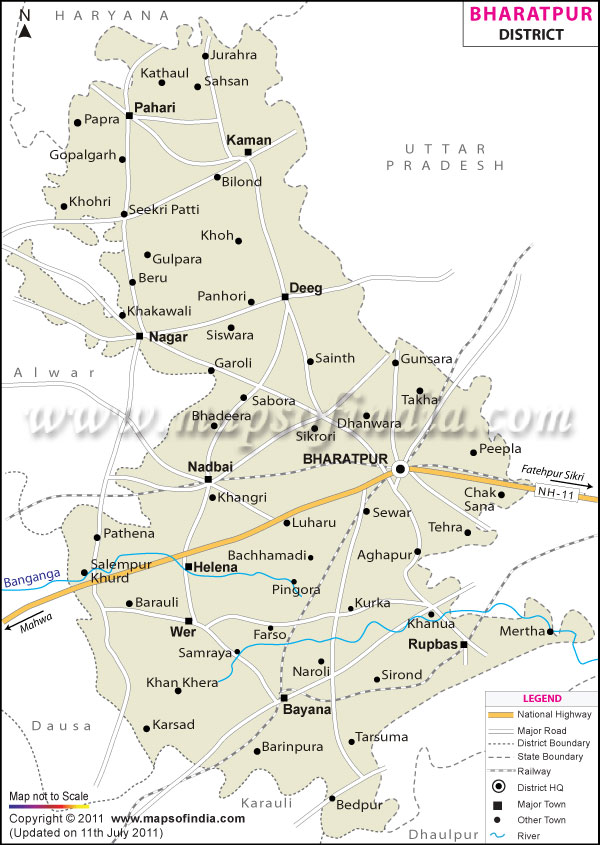
Deep inside Bharatpur district, daily work depends on clear lines of authority split into revenue and field units. Because of this setup, people get steady access to essential services while rules apply evenly across neighborhoods. Running it all sits one central figure - the District Collector and Magistrate - appointed through civil service channels, guiding decisions and linking departments without pause. From village reports to city planning, coordination flows downward only after careful review. Now ten main tehsils shape how Bharatpur runs, after changes in Rajasthan’s setup took effect recently. A different officer runs each one - called a Tehsildar - who handles property details, gathers taxes, plus supports community services nearby. The structure shifts slightly, yet core duties stay fixed under these roles. Oversight stretches across villages and towns alike through this network. Local needs shape daily work more than broad directives do. Across the region, tehsils line up with varying numbers of villages. One spot holds a cluster, another spreads wider. Each area matches its count differently. Numbers shift per location without a fixed pattern. Setup differs from place to place. Arrangement follows local breakdowns. Every division fits its own tally. Structure depends on where you look: Bayana Tehsil: 197 Villages , Bharatpur Tehsil: 206 Villages, Nagar Tehsil: 172 Villages, Rupbas (Roopwas) Tehsil: 164 Villages, Weir Tehsil: 162 Villages,Pahari Tehsil: 136 Villages, Kumher Tehsil: 135 Villages, Deeg Tehsil: 133 Villages, Kaman Tehsil: 128 Villages, Nadbai Tehsil: 125
| Facts of Bharatpur District | |
|---|---|
| State | Rajasthan |
| District | Bharatpur |
| District HQ | Bharatpur |
| Population (2011) | 2,548,462 |
| Growth | 21.29% |
| Sex Ratio | 880 |
| Literacy | 70.11 |
| Area (km2) | 5066 |
| Density (/km2) | 503 |
| Tehsils | Bayana, Bharatpur, Deeg, Kaman, Kumher, Nadbai, Nagar, Pahari, Rupbas, Weir |
| Lok Sabha Constituencies | Bharatpur |
| Assembly Constituencies | Bayana, Bharatpur, Deeg-Kumher, Kaman, Nadbai, Nagar, Weir |
| Languages | Hindi, Braj-Bhasha, English |
| Rivers | Seasonal Rivers - Ban Ganga, Rooparel, Gambhir |
| Lat-Long | 27.217999,77.490642 |
| Travel Destinations | Keoladeo National Park, Iron Fort, The Government Museum, The Palace, Deeg (Excursion), Deeg Fort, Lohagarh Fort, Kishori Mehal, Ganga mandir, Vishwapriya shastri park, Bankebihari temple, Nehru Park, Dev Narayan Temple etc. |
| Government Colleges/Universities | Government College, Government Girls College, Government Law College, M.A.J. Government College, M.S.J. Government College, R.D. Government Girls College etc. |
FAQs
Q1: How many villages are there in Bharatpur district altogether?
One way to look at Bharatpur is through its 1,472 revenue villages neatly grouped within tehsils. Yet another picture emerges when census data includes tiny settlements and empty farmland - then the number jumps to 1,524. Not every patch of land has homes, but each still counts in records. What seems like a single area might hold many named spots on paper.
Q2: Estimated Population of Bharatpur District?
Right now, estimates point to about 30 lakh people living in Bharatpur district by 2026. Back in 2011, census data showed the number stood at 25,48,462.
Q3: Bharatpur District is Known For what ?
Birds from faraway places fill the air above Bharatpur, drawn to Keoladeo National Park, now marked by UNESCO for its quiet global importance.
Last Updated on : June 22, 2026
