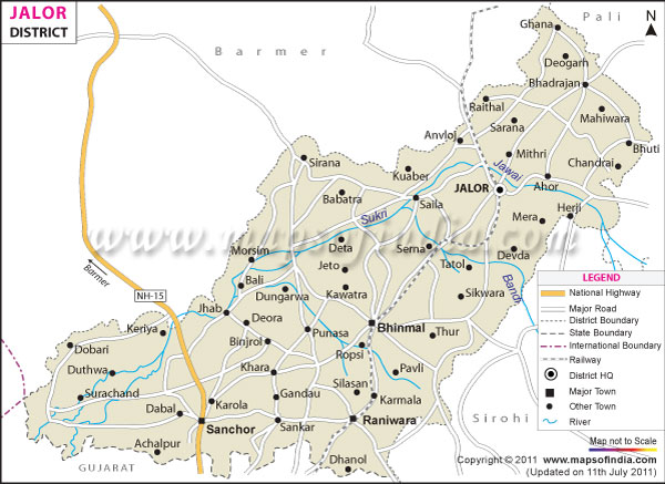
The major towns, villages and cities of the Jalor district are Bhadrajun, Sayla, Megalva, Siana, Ahore, Sanchore, Bishangarh, Hadecha, Ramsin, Daspan, Jaswantpura, Ummedabad, Raniwara, Bagra, Bhinmal, Jalor and Bagoda.
The district is spread over an area of 10,640 square kilometers. Sukri is the main river in the district. The district's climate is very dry with low rainfall and extreme temperatures. It is divided into two sub-divisions namely Bhinmal and Jalor. These cover five tehsils, namely Bhinmal, Sanchore, Ahore, Jalor and Raniwara which in turn cover seven panchayat samities.
The population of Jalor district is around 14, 48, 486. The district has well connected roads and rail links. It is located on the National Highway No 15 (Bhatinda-Kandla). Rail links in the district include the Samdari-Raniwara line, which connects the cities of Jalor and Bhinmal. Jodhpur is the nearest air link to the city.
The district's economy is based on animal husbandry and agriculture. The main crop is mustard oil seed while other crops include barley, wheat, pearl millet, kharif pulses, sorghum and sesame. Minerals found here include bajari, graded fluorite, limestone, granite, gypsum and murram.
Small scale industries in Jalor include marble cutting and polishing, skimmed milk powder, granite slabs and tiles, butter and ghee, mustard seed crushing, leather shoes and handloom cloth.
| Facts of Jalor District | |
|---|---|
| State | Rajasthan |
| District | Jalor |
| District HQ | Jalore |
| Population (2011) | 1,828,730 |
| Growth | 26.21% |
| Sex Ratio | 952 |
| Literacy | 54.86 |
| Area (km2) | 10640 |
| Density (/km2) | 172 |
| Tehsils | Ahore, Bagora, Bhinmal, Jalor, Raniwara, Sanchore, Sayla |
| Lok Sabha Constituencies | Jalore |
| Assembly Constituencies | Ahore, Bhinmal, Jalore, Raniwara, Sanchore |
| Languages | Hindi, Rajasthani including Marwari |
| Rivers | Sukari, Sagi, Luni |
| Lat-Long | 25.130366,72.140922 |
| Travel Destinations | Jalore Fort, Topkhana, Sire Mandir Temple, Fort of Kot Kasta, Quila or Fort of Bhadrajun, Sundha Mata Temple, Jagnath Mahadev Temple, Neelkanth Mahadev Temple, Jahaz Temple, Ahore's Bawan (52) Jinalaya Jain Temple, Jain TempleKirti Stambh & Nandishwar Deep Tirth etc. |
| Government Colleges/Universities | Government College, Government P.G. College, S.R.S.K.J. Government Girls College etc. |
Last Updated on : February 19, 2026
