






About
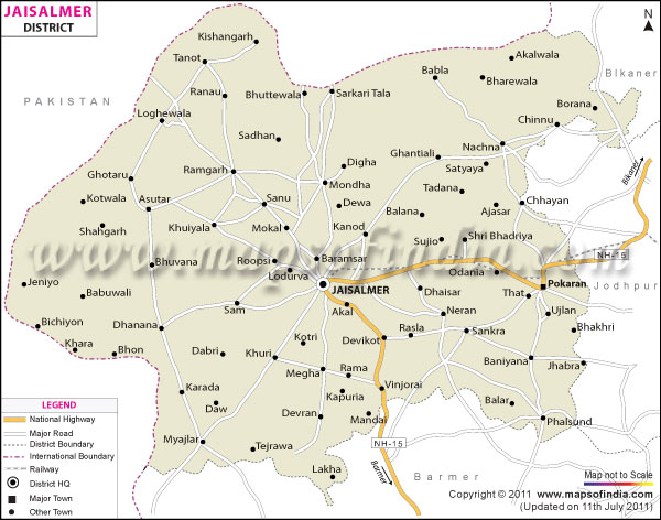
Rising out of nowhere across endless dunes, Jaisalmer seems unreal at first glance - still, it stands firm with quiet history. Covering nearly thirty-nine thousand square kilometers, this place claims size more than most others in Rajasthan. To the northwest, a national boundary stretches alongside Pakistan, shaping much of its outer edge. Inside India, neighboring regions include Barmer, then Jodhpur further east, with Bikaner completing the ring around it. Few places in India match its striking visual presence. Called “The Golden City,” Jaisalmer earns its name through sight, not just speech. Built almost entirely from local yellow sandstone, its architecture spans homes and fortress walls alike. Sunlight at noon strikes the stone, pulling out rich tones like liquid amber. As afternoon fades, shadows stretch, and colors grow heavier, closer to molten gold. What you see then is not an illusion - it is geology and light shaping a landscape into something radiant.
History and Culture
Back in 1156 AD, Rawal Jaisal started the city - this leader belonged to the Bhati Rajputs, a clan known for its long line of royalty. Their roots? Said to stretch straight to Lord Krishna, shaping how people see themselves even now. Seeking safety, he left Lodhruva - a former capital exposed to attacks - for higher ground. His choice: a rugged triangle-shaped ridge called Trikuta. Rising sharply from the flat desert, it offered clear views and strong protection. Because of its position, defense became far more manageable.
Historical Milestones
Perched on key pathways, Jaisalmer thrived economically in medieval times. Across these trails, commerce flowed between northern India and distant lands - Persia, Central Asia, even coastal hubs on the Arabian Sea. Through Bhati-controlled zones, waves of traders moved goods like silk, spice, indigo, gems - all taxed heavily at crossing points. Wealth poured in as a result. Still, such great riches turned Jaisalmer into a repeated aim for competing rulers. Deep wounds mark its past due to prolonged struggles against the Delhi Sultanate. In the closing decades of the 1200s and opening years of the 1300s, the fortress endured crushing blockades, especially under Alauddin Khalji’s assault. As loss loomed unavoidable, women performed Jauhar - choosing collective self-sacrifice by fire - to uphold dignity; meanwhile, warriors wore orange garments before charging into Saka - their last stand meant never returning alive.
Economy
Survival here began long ago, shaped by relentless droughts across Jaisalmer’s barren landscape. Now, government projects share space with mining giants in a region where tourists wander ancient forts under open skies.
Government Sector
Perched near the tense frontier with Pakistan, Jaisalmer's public institutions carry weighty defense responsibilities. Spread across arid stretches, military installations shape much of the region’s economic rhythm. Civilian jobs multiply where soldiers gather, fueled by steady demand for services and materials. From supply chains to road projects, activity thrives around the sprawling army post and airfield. These bases do more than guard airspace - they anchor livelihoods through contracts and construction alike. Besides security matters, attention centers on overseeing the Indira Gandhi Canal Project. Flowing from the Himalayas, this key network extends water far into arid zones up north, reshaping stretches of barren terrain into farm-ready plots. Rural jobs find support too, backed by programs such as MGNREGA, helping distant settlements stay resilient over time.
Public Sector
Despite its size, Jaisalmer drives much of India’s shift toward cleaner energy while managing key natural resources. With strong state involvement, efforts center on these areas: Out here, where the Thar Desert stretches wide, wind energy thrives through thousands of towering turbines. Not far off, Jaisalmer Wind Park stands among Earth's biggest inland wind installations. Public and private efforts together pushed these projects forward over time. Sunlight pours down almost daily without pause across the terrain. Because of that steady brightness, large-scale solar arrays have taken root just like the spinning blades nearby.
Services Sector
Among economic activities, tourism and hospitality take the lead. Thousands depend on these jobs - hotel operators, guides through dunes, those running high-end desert camps, artisans crafting souvenirs, plus people leading camel trails - all tied to visitor flows. Among economic activities tied to tourism, retail stands out in daily life. Jaisalmer draws buyers seeking wool carpets knotted by hand, detailed silver ornaments, fabrics stamped with wooden blocks, yet also leather items shaped from camel skin. Growth in internet access has quietly reshaped services behind the scenes; banks now operate faster, delivery networks stretch wider, communication systems run smoother - each adapting not just for locals but for waves of international visitors arriving every year.
Tourism
Fueled by visitors, Jaisalmer's current economic strength finds its roots in travel. History lives here, shaped by human hands through time - ancient yet active. Out here, old stone buildings rise like echoes of another time, while just beyond, wild land refuses to be tamed. Shape comes from contrast - crafted lines meeting nature’s chaos without warning.
Key Highlights
Inside the high walls of Jaisalmer Fort, called Sonar Qila, people live much like their ancestors did long ago. Life moves at its own steady pace, shaped by habits passed down through generations. The fortress holds homes, shops, temples - all part of a living community. Centuries blend into each day here, quietly, without rush. Time feels different where old ways still guide how things happen. A significant number of people call this fortress home - about twenty-five percent of the historic town’s residents live within its thick sandstone ramparts. Winding paths weave between centuries-old homes and tall havelis stacked one above another. Hidden among them stand seven intricately sculpted Jain temples from the Middle Ages. Most Indian forts have become silent exhibits; here, footsteps echo through active streets.
Over in the old part of town sits Nathmal Ki Haveli, split between two brothers who worked opposite each other, shaping mirrored designs that seem identical until you step near enough to catch their personal marks hidden just off center. Two ancient elephants made of sandstone stand watch there, silent despite changes around them. Rising above rooftops nearby, Salim Singh Ki Haveli tilts upward with weight balanced strangely - heavy on top, thin below, spreading wide at the peak like a vessel slicing waves under storm-lit skies. Out there, balconies stretch forward without support, carved with care. Deep shade pools beneath them, making stillness seem like it could move. These huge homes reshape the rough land below, turning cliffs into something like art you can walk through. Stone sits high above ground, yet somehow does not look heavy at all.
Demographics
One out of every ten people in the state lives here, with records showing 6,69,919 residents by 2011. Males make up more than half - exactly 3,61,708 - while women number 3,08,211. It runs key services others depend on across nearby areas. Jobs and decisions flow through its towns daily, shaping life beyond just local boundaries. Among every thousand men in Jaisalmer, only 852 women are recorded - a figure lower than India's overall count. That gap hints at deeper patterns tied to who lives here and how life unfolds across generations. Over time, the makeup of people shifts slightly with each official headcount. Jaisalmer's ability to read and write stands at 46.07%, reflecting how learning has grown there. While men reach 72.04% in reading skills, women sit at 39.71%, a difference that stretches across 32.3 points. Focused efforts continue from local leaders because schooling matters deeply here. One way to look at it: three talukas split up the district, handling local administration and gathering stats. Spread out over quite some land, people live more thickly in certain parts than others.
Administration
West of Rajasthan lies Jaisalmer, tucked into the Jodhpur Division's oversight. A lone officer runs local affairs, wearing two hats - one for revenue, another for order. Stretching wide with few people inside, it demands sharp planning just to keep things steady. Its edge brushes a tense frontier, making control even trickier than usual. Development efforts unfold slowly across scattered settlements shaped by arid conditions. Across its vast territory, governance takes shape through four key regions. Each handles daily operations within assigned zones. Where one ends, another begins - clear lines guide responsibility. From north to south, these sections split duties without overlap. Split even more finely, these areas form smaller units known as local blocks and tehsils, set up to handle community needs. Across the region, 744 villages exist, grouped within 140 village councils called Gram Panchayats. Stretching far apart - often by vast stretches of shifting sand dunes - these settlements make upkeep difficult. Roads, schools, and clinics must reach places that isolation makes hard to serve. Distance turns basic services into complex tasks for officials on the ground.
| Facts of Jaisalmer District | |
|---|---|
| State | Rajasthan |
| District | Jaisalmer |
| District HQ | Jaisalmer |
| Population (2011) | 669,919 |
| Growth | 31.81% |
| Sex Ratio | 852 |
| Literacy | 57.22 |
| Area (km2) | 24462.42 |
| Density (/km2) | 17 |
| Tehsils | Fatehgarh, Jaisalmer, Pokaran |
| Lok Sabha Constituencies | Barmer, Jodhpur |
| Assembly Constituencies | Jaisalmer, Pokaran |
| Languages | Hindi, Rajasthan ,Marwari , Urdu |
| Rivers | ----- |
| Lat-Long | 26.980829,70.836639 |
| Travel Destinations | Jaisalmer Fort, Patwa Havelies, Salim Singh�s Haveli, Nathmal�s haveli, Madir Palace (Tazia Tower), Gadsisar Lake, Govt. museum & the folk museum, Badabag, Amar Sagar, Ludarwa, Mool Sagar, Kuldhara, Khuri Sand Dunes, Akal Wood fossils Park, Sudhasari etc. |
| Government Colleges/Universities | Government College, M.L.S. Government Girls P.G. College, S.B.K. Government College etc. |
FAQs
Q1: How many villages are located in the Jaisalmer district altogether?
Across the dusty stretches of Jaisalmer’s tehsils, clusters of villages dot the land - 756 in total. These are bundled under one hundred forty local councils known as Gram Panchayats. Not every council handles the same number of towns; it shifts, depending on how many people live there and what the terrain allows. Some areas spread thin with few homes, others huddle closer where water or roads make life easier. Not every village holds equal weight in governance, yet all fall within this decentralized rural framework.
Q2: What is the population of the Jaisalmer district?
One person lives here for every seventeen kilometers of sand. The census taken in 2011 counted exactly six hundred sixty-nine thousand nine hundred nineteen people. Huge stretches of land stretch empty under wide skies. Few settle where dunes shift, and water hides deep below. Sparse settlement patterns define much of the terrain here. Population density, therefore, ranks lowest within the state.
Q3: What is the Jaisalmer District Known For ?
Jaisalmer draws global attention thanks to the still-inhabited Jaisalmer Fort, known locally as Sonar Qila. Rising from the desert, its glowing yellow sandstone buildings earn it the nickname “The Golden City.” Expansive dunes stretch beyond town - Sam Sand Dunes invite quiet reflection. Music pulses through daily life here, rooted in lively Rajasthani traditions passed down for generations.
Last Updated on : June 22, 2026
