




About
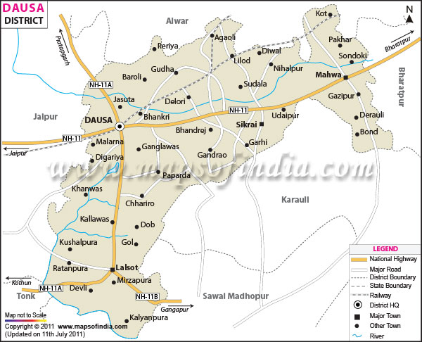
Heaven-like beauty? That’s what people think when they hear Dausa - though spelled Dausa now - born from the old tongue, Dhau-sa. Hills do not roll gently here - they jut, cracked and weathered, guarding forts older than memory. The villages stretch far beyond sight, linked by dust paths and shared stories passed through seasons. East of Dausa, Bharatpur spreads wide. Under Jaipur's oversight, the area holds steady. Northward, Alwar marks the edge. Down south, Sawai Madhopur takes place. Karauli fills the southeast stretch . On the western edge, it meets Jaipur directly. Spread across nearly 3,432 square kilometers, this place may seem small on state maps. Still, when counting people per square kilometer, few areas compare. Its past also holds weight - older names echo through older walls. Size does not always show significance. Some spots carry more than land can measure. This one does. Quietly.
History & Culture
Back when Jaipur was just a thought, Dausa already held sway. Power settled there early under the Kachwaha rulers, long before Amber rose. Its name carries weight because it stood first among their capitals. Not later, not elsewhere - here began their reign. Long before most kingdoms took shape, about 967 AD saw Dulha Rai, a determined Rajput leader, take hold of Dausa from the Badgujar clan and Meena chiefs. High ground mattered to him - that is why he turned it into his base. From there, over years stretching quietly forward, the Kachwahas pushed influence through eastern Rajputana. Their moves in time helped build what would become the kingdom later known as Jaipur. Out past the royal family drama, Dausa saw plenty unfold during medieval and British times. Folk songs and dances here speak clearly about who people are. Out in Dausa, voices rise sharp and loud in contests known as Hela Khayal - a sound that cuts through Rajasthan’s air. Instead of quiet tunes, there’s a thunderous rhythm from the Naubat, an enormous drum whose beat shakes the ground. Sharp words fly during these matches - jokes sit beside old stories and pointed remarks on power and society. From miles around, village crowds gather when the music begins, pulled not by show but something deeper. Festivals in Dausa unfold through shared joy, marked by steady devotion. Crowds gather, voices rise, moments pass in rhythm with old customs. Each event binds neighbors not just in practice but in quiet understanding. Laughter travels between homes when rituals begin. These times are lived fully, felt widely - rooted more in habit than show.
Economy
Farming shapes daily life in Dausa, yet factories are springing up at speed. Stone extraction fuels part of the economy, while shops and trade keep money moving. Industry creeps in beside traditional fields, shifting how people earn. Business thrives without overshadowing rural roots.
Government Sector
Most jobs here stay steady because the government keeps things running. When you look beyond offices that handle paperwork, law enforcement setups, or court systems, there's more going on. Public building projects get strong backing from state funds. Water control efforts cover vital areas like the Banganga and Morel rivers. Farm assistance units spread help directly into rural zones. Most professionals here find jobs not only in public health services but also across a growing number of schools, colleges, and training centers run by the state. While some work directly in clinics and hospitals, others teach or manage operations inside these widely spread learning hubs.
Public Sector
Here, government-backed banks reach people through local offices while storage facilities run by the state help manage supplies. Maintenance centers and transport services stretch across the region because RSRTC uses Dausa’s central position at connecting roads. Dairy cooperatives work alongside these structures, adding another layer of support. Being where major routes meet makes it practical for such operations to settle in. Out in the fields, JVVNL keeps electricity flowing to powerful irrigation pumps - also reaching new factory areas growing on the outskirts. Power lines stretch far because farm demands stay high while industries slowly spread across regions once used only for crops.
Services Sector
Out here in Dausa, service jobs are shifting fast - thanks mostly to its spot on the Delhi-Mumbai Expressway. That position? It’s pulling in wave after wave of truck stops, roadside eateries, storage hubs, and garages fixing vehicles day and night. Out here, shops do well in towns such as Dausa City, where daily items move fast through local trade centers. Instead of big banks, small lending groups often handle money matters close to home. Meanwhile, places like Bandikui see steady flows of building materials and farm needs passing through busy market lanes. On top of that, buying and selling crops supports many businesses tied to farming life. Lalsot joins in too, linking rural supply chains with city demand. These activities feed into a web of profit-driven exchanges shaped by real-time crop pricing and neighborhood credit systems.
Tourism
Hidden among Rajasthan's dusty trails, Dausa holds secrets for those who love old stories carved in stone. Not many expect such grand feats of design tucked away in quiet corners. Some structures here have stared down centuries, still standing tall under harsh sun. A few bridges and temples grab attention without trying too hard. Cameras often linger on details others might miss - angles sharp enough to cut light. Even skeptics pause when they see how stone meets sky. Few places balance age and art so quietly. Rituals unfold just as they did long ago, shaped by belief older than memory. Visitors often speak of quiet shifts - something seen, felt, released within those bounds. Not everyone understands what happens there. Yet year after year, crowds return, carrying hope like an offering. High on a rocky ridge called Devgiri, Dausa Fort looks down over the town like a quiet watcher. Rising in the early days of Rajput rule, its walls are broad, built to hold strong against attack. Entry points stretch wide, heavy stone structures that speak of old power. Watch posts stand at intervals, once home to eyes scanning distant horizons. Inside live age-old shrines - some carved for Shiva, others honoring Nilkanth. From these heights, sightlines sweep across rooftops and lanes far beneath.
Demographics
Around Dausa, people live close together, sharing similar traditions, most still outside cities yet moving fast toward urban life near busy transport routes. Total Population1, 1,634,409. Population Density 476 Persons Per Km² Decadal Growth Rate 24.09 Percent 2001 To 2011. Sex Ratio 905 Females Per 1,000 Males. Overall Literacy Rate 68.16 Percent. Among those living in Dausa, tribal groups hold strong influence - especially the Meena people - who stand alongside a large number of individuals from scheduled castes. These communities, linked by history and daily life, quietly guide how things unfold in politics, society, and custom. Even though most people can read and write - about 68 out of every 100 - the difference between men and women remains sharp. Men show strong numbers, close to 83 percent able to read. On the flip side, just over half of women have basic literacy skills. Efforts by authorities continue, trying to close this divide slowly. Still, progress feels uneven across genders. Most folks speak Dhundaari or Bagri at home, these being local forms of Rajasthani heard in villages and small markets. Yet when it comes to school, official work, or serious business, everyone turns to standard Hindi without exception.
Administration
From an organizational standpoint, Dausa manages a tightly woven cluster of countryside settlements through clear hierarchies. Falling within the jurisdiction of Jaipur's governing zone, oversight flows through one central figure holding dual responsibilities - one handles civil governance while also steering public safety initiatives forward. One way to handle local administration? Split the area into 15 Tehsils for land tax and oversight. Some of these divisions have long played key roles in managing civic duties - places where history meets function. Under the tehsil setup, village-level decision making flows via 11 block councils along with 284 local panchayats. Most folks know Dausa by how many small villages dot its land. This place holds 1,109 official villages, with just 30 sitting empty while the rest stay lived-in. You will not find modern labels here like those fresh plots near canals in other districts. Each settlement carries an old name full of weight - names such as Bhandarej, Didwana, Geejgarh, or Digo tell quiet stories. These names grew from centuries shaped by family lines, farming roots, and clans that stayed put.
| Official Name | Dausa |
| Location | Haryana |
| Area | 3429 sq. km |
| Population | 1,634,409 9 (2011) |
| Language | Hindi, Rajasthani , Dhundhari |
FAQs
Q1: How many villages are there altogether in Dausa district?
One thousand one hundred nine villages sit inside Dausa district, as per the government count. Among them live people in 1,079 places where farming and handmade work still shape daily life. Every single spot carries a name rooted deep in older times. The number of people living in Dausa district adds up to a specific count. That figure is recorded based on recent surveys. It reflects everyone across towns and villages there. Population size shifts slightly over time due to various factors. Still, official sources hold the most accurate version.
Q2: What is the Population of the district ?
Total Population is 1,634,409. Population Density: 476 persons per km². Decadal growth rate: 24.09 Percent 2001 to 2011.
Q3: What is the district famous for ?
From ancient roots grows its name, built on Sanskrit sounds meaning beauty close to heaven. Once stood here the starting seat of power for the Kachwaha rulers, long before Amber rose. This soil saw leadership begin, shift westward, then climb toward what would become Jaipur. History rests deep in its lanes, quiet but present, older than most remember.
Last Updated on : July 17, 2026
