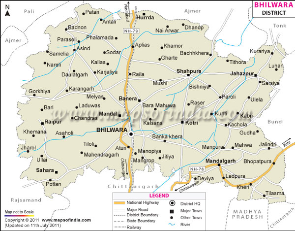
Bhilwara district in Rajasthan is spread over an area of around 10,455 sq Km. It is surrounded by the districts of Ajmer, Bundi, Chittorgarh and Rajsamand. Like other parts of the state, Bhilwara district in Rajasthan has a dry climate. The summer season is hot while the winter season is cold. The ideal time for Bhilwara travel is between the months of October and March.
There are lots of tourist attractions in Bhilwara district which attract plenty of tourists. The district is known for its rich tradition and culture. A number of sightseeing tours are offered by the local tourist board and the travel agencies. Some of the popular places in the district are:
- Bagore
- Badnore Fort
- Asind
- Mandalgarh
- Shahpura
A number of roads connect the district of Bhilwara to other cities of India. The nearest airport is located in the city of Udaipur.Udaipur is easily accessible from Bhilwara by roadways and railways. One can also reach the district through roadways from Delhi, Chandigarh, Jodhpur and Jaipur.
| Facts of Bhilwara District | |
|---|---|
| State | Rajasthan |
| District | Bhilwara |
| District HQ | Bhilwara |
| Population (2011) | 2,408,523 |
| Growth | 19.60% |
| Sex Ratio | 973 |
| Literacy | 61.37 |
| Area (km2) | 10455 |
| Density (/km2) | 230 |
| Tehsils | Asind, Banera, Beejoliya, Bhilwara, Hurda, Jahazpur, Kotri, Mandal, Mandalgarh, Raipur, Sahara, Shahpura |
| Lok Sabha Constituencies | Bhilwara |
| Assembly Constituencies | Asind, Bhilwara, Jahazpur, Mandal, Mandalgarh, Sahara, Shahpura |
| Languages | Hindi, Rajasthani including Mewari |
| Rivers | Bedach, Kothari, Khari, Seasonal River - Banas |
| Lat-Long | 25.463115,74.769745 |
| Travel Destinations | Sawai Bhoj Temple, Gangabai Cenotaph, Mandakini Temple, Ramdwara, Mandalgarh, etc. |
| Government Colleges/Universities | Government Law College, Govt. College, M.L.V Government College, S.C.M. Government College, S.M.M. Government Girls College, S.P.S.B. Government College etc. |
Last Updated on : February 19, 2026
