


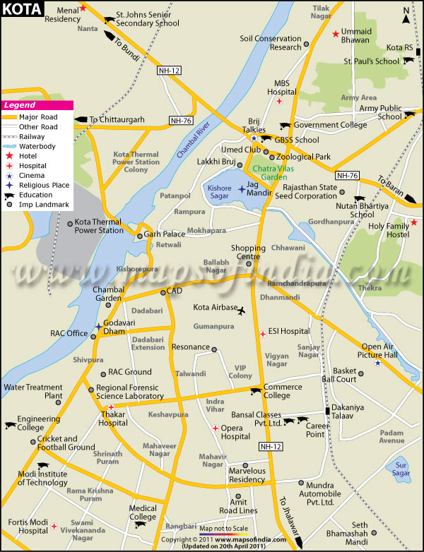





About
Located in south-eastern Rajasthan bordering the banks of the river Chambal, Kota district is probably one of the most diverse and active districts across the entire state. A Kota district map shows ravines, richer river plains and woodland hills with the land better than a lot in Rajasthan, which is associated with dry pools over 5,217 square kilometres. The Kota district map categorises it into the historically-important Hadoti region, which has experienced Rajput kingdoms rising and crumbling, Mughal ambitions flourishing and then fading in India’s steady march toward a modern republic.
Kota is known nationally by three defining descriptors: its coaching institutes, its Kota Stone and, more recently, for the Kota Doria fabric — an ornate, light-weight cotton-silk weave revered to this day. These three pillars have become the new national and regional consciousness of the Kota district. The Kota district map depicts a well-endowed territory that is packed with rivers, dams, wildlife reserves and monuments, thus amply qualifying it to be important for the traveller as much as an all-important student, industrialist or historian.
History and Culture
Kota district has shown its deep history associated with the Hada Chauhan Rajput heritage. During the 14th century, a Hada chieftain known as Rao Deva, who was known for conquering that area and establishing what would evolve into the Hadoti kingdom, which would obviously include areas of modern-day Kota district (Kota), Bundi District, Baran District & Jhalawar. The Kota district map from the time helps one to eventually realise the geographical importance of this region, because it is on the eastern bank and with a major river separating Rajasthan from its due share. Kota continued to be a fief of the Bundi rulers for hundreds of years. The region was not given its own distinct political nature until the early 1600s.
The formal recognition of the independent state of Kota came in 1631, when Rao Madho Singh (Rao Ratan Singh's second son from Bundi) was granted their territory by Mughal emperor Shah Jahan. This event signified the commencement of such a culture, architecture and artistic awareness in the political history visible on the Kota district map. Before long, the successor state of Kota grew to eclipse its parent with a larger area, greater revenues and an equally formidable military.
The culture of the Kota district is particularly well known and also seems to be much influenced by the Rajput tradition from medival era. The Dussehra celebration at Kota is among the most famous in Rajasthan, and even the tourists from across India experience a great and wonderful time enjoying this festival with their amazing processions as well as burning giant effigies symbolizing Ravana, Kumbhakaran and Meghnath. As for the rest of them, they have had their traditions intact — however mean-spirited. Teej, where devotees pray unto deities such as Parvati; Gangaur, wherein women seek blessings from Lord Shiva too, and Kartik Poornima are others that remain.
Economy
Economy Kota district is among the most diversified economies in Rajasthan, supported by agriculture, heavy industry, services sector and an expanding education economy. A look at the Kota district map explains how this diversity has been possible — its close proximity to the Chambal region, which had always catered agriculture activities and industrial output, along with the presence of major road-rail junctions here have increased the movement of trade & commerce.
Government Sector
Kota has a very significant contribution of the government to its economic structure. Located at Rawatbhata near Kota, the Rajasthan Atomic Power Station (RAPS) is perhaps one of India's most strategically important nuclear facilities and a huge source for jobs and pride in the district. In the same way, these include complexes like Kota Thermal Power Plant and Anta Gas Power Plant - two large state-run plants that provide electricity in much of Rajasthan as well, but are now outposts for technical workers there; they also continue to employ lots fewer administrative professionals.
Public Sector
In the Kota districts, one can see Chambal Fertilisers and Chemicals Limited (CFCL), based out of Gadepan — Asia's biggest single-location producer of urea-based fertilisers. Not only does this facility help a great deal in the agricultural productivity of the entire northern India, but it is also one of the largest employers in this district. Another major public-private enterprise is DCM Shriram Industries; a large industrial presence has been in Kota involving chemicals, textiles and engineered products. In several stretches, the Kota district map depicts a string of these colossal facilities along the Chambal River corridor, where water availability and access to power have made industrial development viable since historical times.
Services Sector
Since the late 1980s and early 1990s, Kota's services sector has changed almost overnight -- all as a result of coaching. After shutting down a few large industrial facilities, residents founded preparatory colleges for engineering and medical entrance tests. Kota's coaching industry – inspired by brands like Allen Career Institute and Resonance, draws an estimate of 150k–200k students annually, contributing thousands of crores in revenues while supporting a full-blown ancillary economy consisting of hostels & messes, transport/rentals/retail/healthcare.
Tourism
Over the years, tourism in the Kota district has quietly blossomed on a time-honoured tradition of royal architecture (palaces and forts) against a rich background of scenic natural beauty as well as significant religious importance. Kota may never be able to compete with tourism-winning cities in Rajasthan, including Jaipur and Udaipur, but if one looks at the Kota district map, it displays a treasure trove of trekking routes that have started attracting more & more attention among local tourists as well as overseas tourists. A close look at today's Kota district map reveals that most of the better attractions are either strung along the Chambal River corridor (in like manner to four other districts in India) or behind forested tracts down south.
The Chambal River itself is a huge tourism resource. Boat safaris from the forest office jetty located close to Chambal Garden take tourists on a 2-hr of rocky gorge with sights of gharial crocodiles, marsh crocs, vultures and once in a while leopards. The splendidly picturesque shrine of Garadia Mahadev Temple, dedicated to Lord Shiva, is about 12 km from the city on top of a cliff over looking Chambal gorge. Soon after, the Mukundra Hills Tiger Reserve joined as Rajasthan's third tiger reserve (the other two being Ranthambore and Sariska), this time located at a distance of 50 km from the city & staying true to its name allows one an encounter with tigers along with leopards, sloth bears inside the woods and over 266 species of birds above your heads.
One of the oldest known forms Kansua Shiva Temple, contains a rare four-faced lingam, possibly dating back to the 8th century and is a high pilgrimage site for Hindus. Chambal Garden, located on the southern riverfront, has got beautiful designed garden which is good for walking and picnics. Rajasthan's ancient Baroli Temple complex, a cluster of 9th and 10th century temples devoted to many Hindu deities situated about 45 km from the city by the Chambal, has one of Rajasthan's best examples of early medieval temple architecture. A cursory look at the Kota district map will reveal many more such tourist attractions — ranging from the Geparnath Mahadev Waterfall to Abheda Mahal, which is a silent representation of history and proves yet again this region's tourism potential has only been scratched.
Demographics
As per the Census of India 2011, Kota district had a population of 1,951,014 in the year 2011, out of which males were 52.30 per cent and females were 47.70 per cent. There were 911 females to every 1,000 males, which was marginally less than the Rajasthan state average of 928.
It also had a human population density of 374 persons per square kilometre. By area of settlement, 60.31% population was living in urban areas, which also indicates the high level of degree on Urbanisation as Kota is an industrialised and educationally active district when compared with other districts around Rajasthan. Around 13% of the total population was in the age group between (0-6), with there being a reported population of children for this respective category at approximately 255,056. Hindi is the main language spoken by most of the populace in the Kota district and Rajasthani, with its various regional dialects found across the Hadoti belt.
Administration
Kota district is the administrative headquarters of Kota division circle, one of the major divisions in Rajasthan. Kota district map shows, neighbours in order are Bundi to its north-west, Baran to the east, Jhalawar, the southern side of Chittorgarh, the west Revenue administration, law and order, and Development Programmes. Despite most states controlling the rate of funds flowing in and out for development programs, directly from their offices, with district magisterial power.
The district — which is further divided into five tehsils, Ladpura, Ramganj Mandi, Sangod, Digod and Pipalda —has day-to-day administrative work. All tehsils act as an administrative territory below the district, by processing land records and issuing certificates, along with a few other local governance functions. Out of them, the most populous tehsil by far is Ladpura with a total population of around 1,143,792 (2011 Census), due to being entirely within Kota city, which makes it urbanised.
It covers an entire Lok Sabha (Parliamentary) constituency and includes six Vidhan Sabha (Assembly) constituencies. The focus of district administration has been slowly shifting towards the development/ improvement of rural infrastructure, medical delivery system and education, especially women's education for tourism and heritage conservation through implementation and running various central & state government schemes in many villages/town with the district over the past few years.
FAQs
Q.1:What is the total number of villages in Kota district?
Kota district has approximately 874 villages.
Q.2:What is the population of Kota district?
According to the 2011 Census, Kota district has a population of 1,951,014 people.
Q.3:What is Kota district famous for?
Kota district is famous for its coaching institutes, Kota Doria sarees, Chambal River and industrial development.
Last Updated on : June 22, 2026
| Find Distance from Kota to other Indian Cities | |||
