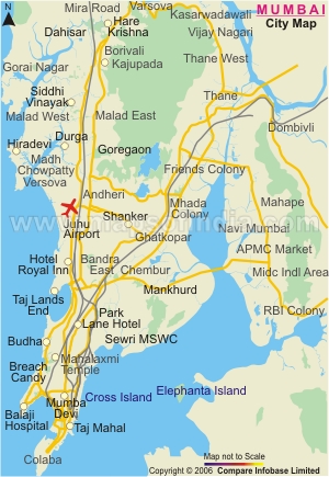

Currently, Mumbai City is the result of a significant extent of development carried out on the seven islands mentioned above. The city is famous for its historical background. However, the presence of the city is just as luminous. The city has been given many sobriquets like the "city of dreams" or the "city that never sleeps". The reason behind this is the powerful existence of Bollywood or the Hindi film industry.
Today, Mumbai, or erstwhile Bombay, ranks as the biggest metropolitan region in the country. The city is home to more than 13 million people. As a result, Mumbai is among the most populous cities in the world. Mumbai/Bombay is one of the top ten commercial hubs in the world by worldwide economic transactions. The city offers endless job and career opportunities to the people of India. It is one of the important reasons why so many people across the country come to Mumbai to earn their livelihood. The city stands out from other cities in India because of its energetic lifestyle and abundance of tourist destinations. Mumbai is currently one of the top-rated tourist destinations in India. In addition, it houses a national park inside its precincts (Sanjay Gandhi National Park), which is a unique feature that only a limited number of cities in the world have.
Mumbai Map with Districts, Areas and Major Locations
The map of Mumbai provides a detailed overview of the city, covering its districts, neighbourhoods, key locations, and surrounding areas. The city of Mumbai is split into two administrative divisions – Mumbai City district and Mumbai Suburban district. The map of Mumbai district gives an understanding of the distribution of important areas, suburbs and connectivity routes in this city.
Mumbai Suburban district consists of 3 tehsils, namely Andheri, Kurla and Borivali, whereas the southern part of the city is termed as South Mumbai. The city district covers significant areas such as Worli, Mumbai Central, Lower Parel, Prabhadevi and extends from Mahim and Sion in the north to Colaba in the south.
A Mumbai city map also shows the western suburbs, the eastern suburbs and the major areas in the city, including Borivali, Bandra, Andheri and Dadar. It also depicts the linkages of Mumbai to the adjoining areas like Thane and Navi Mumbai.
Mumbai Map Showing Major Areas
Mumbai is divided into various areas, each of which has its own significance. South Mumbai, Western Mumbai and Eastern Mumbai are the major areas. A detailed Mumbai map with areas helps users understand the location of these important regions.
South Mumbai Map
The historical and old city of Mumbai is at the heart of the city in South Mumbai, which features famous landmarks, business districts and heritage buildings.
Important locations include:
- Fort – A commercial area that used to be part of the fort, now with colonial architecture.
- Colaba – a popular tourist and shopping area in the south.
- Marine Drive – One of the popular coastal highways of the Arabian Sea.
- Churchgate – An important transport/commercial hub.
Western Mumbai consists of several important suburbs, which are linked by connecting roads, railways and Metro.
Key areas are:
- Bandra – A popular residential and commercial neighbourhood.
- Andheri – It is a major suburb, having offices, residences and transport links.
- Goregaon - Residential and business areas
- Uptown – The area of the town that is growing, industrial and residential.
Eastern Mumbai Areas
Important suburban areas in Eastern Mumbai with good connectivity towards Thane and other areas. Major areas include:
- Mulund – A suburb close to the Thane connection.
- Ghatkopar – an important residential and transport centre.
- Vikhroli – A significant eastern suburb that is developing.
Demographics of Mumbai
This Western Indian city is the 6th most populous city in the world and the 3rd most populous city in the nation. The following are the demographic details of the city:
- Total population: 12, 478, 447, according to the 2011 census (12.4 million or 1.24 crore)
- Metropolitan population: 18, 414, 288
- Total male population: 6, 736, 815
- Total female population: 5, 741, 632
- Density of population: 20, 694 per sq. km.
- Growth of population: 12, 478, 447
- Growth rate of population: 4.7 %
- Rate of literacy: 89.7 %
- Sex ratio: 848 females per 1, 000 males
- Official language: Marathi
- Main religion: Hindus (67.39 %), Muslims (18.56 %), Buddhists (5.22 %), Christians (4.2 %), Jains (3.99 %), Sikhs (0.58 %) and Jews, Parsis and other religions (0.6 %)
Tourist Places in Mumbai
The city of Mumbai has numerous places of visit, which attract tourists from domestic as well as international destinations. To name a few of them are:
Afghan Church: Located in the quiet atmosphere of the army cantonment in the southern part of the city, this church of the Evangelist St. John was constructed in the year 1858 and is made of lofty limestone.
Banganga Tank: This is a famous, quaint and ancient Jain pilgrimage on the way to the Malabar Hills.
Chhatrapati Shivaji Maharaj Vastu Sangrahalaya: Formerly called the Prince of Wales Museum, this museum was established in the 20th Century. Apart from reflecting the Victorian architecture, this museum of Mumbai has a collection of ancient and rare artefacts of natural history, archaeology and art.
Elephanta Island: This island is known for its rock-cut temples. This World Heritage Site is a complex, which includes shrines, inner cells, courtyards, porticos and grand halls that are filled with some exclusive stone sculptures of Lord Shiva and other Gods and Goddesses of the Hindu religion.
Essel World: Based in West Borivali, this is one of the renowned amusement parks in the city, which has a number of joy rides.
Gateway of India: Built to commemorate Queen Mary and King George V's visit to India, this is the most popular monument of the city. Motor launches are available from the back of the arch to take you on a short cruise so as to explore the natural harbour of this city.
Hanging Gardens: Situated near the Malabar Hill, this well-maintained park provides a picturesque view of Mumbai city.
Mani Bhavan: This used to be the home of Mahatma Gandhi, which has now been turned into a museum that exhibits some of the things used by Gandhiji.
Marine Drive: Even known as the "Queen's Necklace" for the evening lights, this place offers a panoramic view of the sunset.
Chowpatty Beach: This seaside beach is one of the ideal places for evening hangouts in the city. The food stalls on the beach serving local bhel puri and pav bhaji just add on to the people's enjoyment.
Besides the ones mentioned above, names of some of the other tourist attractions in and around Mumbai are:
- Aksa Beach
- Borivali National Park or Sanjay Gandhi National Park
- Dr. Bhau Daji Lad Museum
- F. D. Alpaiwalla Museum
- Haji Ali Mosque
- Jama Masjid
- Juhu Beach
- Kamla Nehru Park
- Mahalakshmi Temple
- Mumbadevi Temple
- Mumbai Port Trust Garden
- Nariman Point
- Nehru Science Centre
- Suraj Water Park
- St. George Fort
- Veermata Jijabai Udyan (Zoo)
Resources of Economy in Mumbai
This city, being the richest Indian city, has the highest Gross Domestic Product (G. D. P.) among all the other cities of West, South, and Central Asia. This commercial capital of India is a land of innumerable multi-national companies, domestic as well as foreign banks, financial institutions, etc. To name a few are Wipro Limited, Larsen and Toubro, Tata Group, State Bank of India, Reliance, Life Insurance Corporation of India (L. I. C.) and Godrej. Though in the earlier days, the economic resources were limited to seaport and textile mills, presently the sources of economy of this city include healthcare, engineering, polishing of diamonds, and Information Technology (I. T.).
Modes of transport in Mumbai
Mumbai city can be reached from any part of the nation as well as the major international destinations by one or the other modes of transport, which are mentioned below:
Air Transport
Chhatrapati Shivaji International Airport, located at a distance of around 28 km from the heart of the city, is the main and the nearest airport to the city. This busiest airport in India has international flights operated by the following airlines:
- Air Asia
- British Airways
- Delta
- Emirates
- Lufthansa
- Malaysia Airlines
- Qantas and Singapore Airlines
- Go Air
- Indigo
- Jet Airways
- Spice Jet
Indian Railways helps the city connect to places all over the nation. Chattrapati Shivaji Terminus, earlier called Victoria Terminus or V. T., Kurla Terminus, Dadar Terminus and Churchgate Railway Station are the 4 important railway stations in the city.
Road Transport
The capital city of Maharashtra has a number of highways passing through it, which help the city connect to the neighbouring areas as well as distant places. To name some of them are:
- Eastern Express Highway
- National Highway 3
- National Highway 4
- National Highway 6
- National Highway 8
- National Highway 9
- National Highway 17
- National Highway 222
- Western Express Highway
- Eastern Freeway
- Mumbai - Nashik Expressway
- Mumbai - Pune Expressway
- Mumbai - Vadodara Expressway
- Sion Panvel Expressway
- Western Freeway
Where is Mumbai Located on India Map?
Mumbai is located in the state of Maharashtra on the western coast of India. The map of Mumbai in India highlights its location along the Arabian Sea coastline and its importance as a major coastal city.
Mumbai is part of the Konkan region and is connected with nearby areas like Thane and Navi Mumbai. A Mumbai location map helps understand its geographical position, surrounding regions, and connectivity with other parts of India.
The Mumbai area map provides a clearer view of Mumbai’s neighbourhoods, nearby regions, and important locations.
FAQs
Q1: Where is Mumbai located on the India map?
Mumbai is located on the western coast of India in the state of Maharashtra, along the Arabian Sea coastline.
Q2: What are the major areas shown on the Mumbai map?
A Mumbai map with areas shows major areas such as South Mumbai, Andheri, Bandra, Dadar, Borivali, Goregaon, Malad, Mulund, Ghatkopar, and Vikhroli.
Q3: What are the main regions of Mumbai?
The main regions of Mumbai include South Mumbai, Western suburbs, and Eastern suburbs.
Q4: What are the famous places shown on the Mumbai city map?
A Mumbai city map may show famous places like the Gateway of India, Marine Drive, Colaba, Churchgate, Fort, Worli, and other important landmarks.
Q5: What is the old name of Mumbai?
The old name of Mumbai was Bombay. The city was officially renamed Mumbai in 1995.
Q6: How many districts are shown on the map of Mumbai?
Mumbai is mainly divided into two districts — the Mumbai City district and the Mumbai Suburban district.
Q7: Which areas are famous in the Mumbai suburbs?
Popular suburban areas include Andheri, Bandra, Borivali, Goregaon, Malad, Mulund, and Ghatkopar.
Last Updated on : June 25, 2026
Mumbai Maps
