
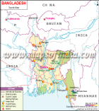
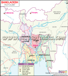
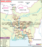
Bangladesh and India are demarcated by an international border. This border demarcates the Indian states and six divisions of Bangladesh. West Bengal, Mizoram, Assam, Tripura and Meghalaya are the Indian states that share their borders with Bangladesh. Dhaka, Rangpur, Khulna, Sylhet, Rajshahi and Chittagong are the six divisions of Bangladesh that are situated along the India-Bangladesh border. The demarcated portions on both the sides are fenced.
Both the countries share a 4,096-kilometre long border, which is also the world's fifth-longest land border. The Border Security Force (BSF) of India and the Border Guards Bangladesh (BGB) of Bangladesh are involved in the patrolling of the border area. The border from West Bengal in India encircles the entire area of Bangladesh and finally ends at Northeast India. The border divides the Sundarban mangrove forest and the Ganges delta region and is crisscrossed by many rivers. The area near the borders is densely populated. At some places, the border passes through villages and even some buildings.
Within the borders of both the countries, there are many Indian enclaves in Bangladesh and many Bangladeshi enclaves in India. The people living in these enclaves have to suffer a lot as they are not able to get any of the government services they are entitled to.
To control the smuggling of narcotics, India is building an Indo-Bangladeshi barrier with a fence of barbed wire that will run over an area of 3,406 kilometres. In the West Bengal section, India has also installed flood lights in the entire 277-kilometre region.
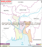
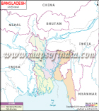
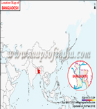
The map on this page shows the Republic of India and the People's Republic of Bangladesh and the borders that the countries share. The Indian subcontinent is shaded with yellow colour, while Bangladesh was highlighted in green colour. The black dotted lines depict the countries' boundaries. The major cities in both the countries are marked with red dots. Some of such cities marked in India are Jammu, Ahmedabad, Hyderabad, Kanyakumari and many more. The white dots are used to indicate other cities in India. The capital cities of both the countries, New Delhi of India and Dhaka of Bangladesh, are also depicted in the map. The other neighbouring countries to both the nations like Bhutan, Pakistan, China, Nepal and Myanmar are also shown in the map. It also shows the three major water bodies surrounding India; namely, the Bay of Bengal, the Arabian Sea and the Indian Ocean. The rivers passing through both the countries are marked with blue lines.
WBST270515
WBVDA
Bangladesh Maps
Last Updated on : December 17, 2019