






About
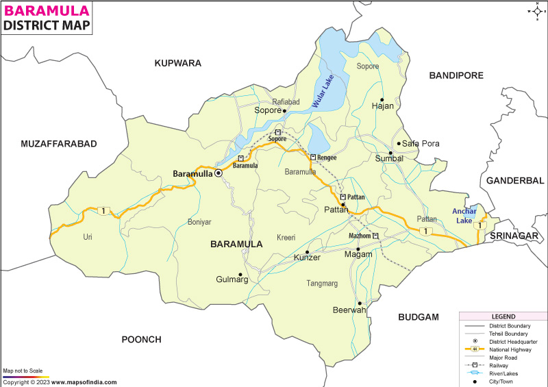
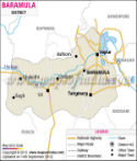
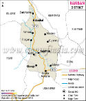
Bramulla sits in the northern stretch of Jammu and Kashmir's Kashmir Valley, shaped by time, terrain, and significance. Though small on maps, its past stretches deep - serving ages ago as the main threshold into the valley from lower India. Instead of just roads today, old pathways still echo trade links once tied to Central Asian circuits through Persia. To its north lies Kupwara; shifting eastward brings Bandipora, then Ganderbal into view. Southeast leads to Srinagar and Budgam, while heading south opens up Poonch. Westward, however, marks something sharper - the Line of Control, a tense divide bordering Pakistan-held Kashmir. Because of where it rests, movement here matters - not only for people, culture flows freely across influences - but defense watches closely too.
History & Culture
Built into the story of Baramulla lie layers of old beliefs, shifting kingdoms, yet pathways worn by rulers and traders alike. Its name slips from Sanskrit - Varaha, which stands for boar, while Mula points to origin or base. Once, so records tell, including the Rajatarangini, Kashmir rested under a vast stretch of water named Satisar. From the divine tale comes this image: Vishnu, shaped like a furious boar, crashes into stone right here, splitting open the land. Water rushed through that break. Out poured the flood, leaving behind soil, sky, space - the valley now seen. As Baramulla’s story moves from legend to historical events, its significance remains rooted in both myth and tangible history. These legends set the stage for historical developments that followed.
Long ago, in the eighth century, stone temples rose inside Buniyar by order of King Avantivarman, while faraway monk Xuanzang passed through, recording its name among active hubs for Buddhist thought. Through slow years, Mughal rulers favored this route when fleeing Delhi heat for Kashmir’s shaded valleys. Later, in 1947, violence struck - tribal forces surged forward, making Baramulla a battleground; there, figures such as Maqbool Sherwani gave their lives delaying enemies before soldiers arrived - an event etching loyalty into the area’s bond with India.
Though unspoken, the rhythm of days here follows a pattern older than memory - life unfolds slowly among hills and hamlets, shaped by coexistence. Where different communities settle into shared routines, tolerance grows without fanfare. Not through force, but habit, residents uphold a balance built on everyday gestures. Even silence between neighbors carries meaning, a kind of understanding passed down like heirlooms. Across lanes and fields, actions speak before words ever need to.
Among the valleys, voices carry Kashmiri in soft rhythms along narrow paths. Over steep inclines, Pahari rises where mountain communities settle into daily life. Through lower meadows, Gojri moves quietly between herding villages. Each dialect shifts subtly as terrain changes. Sound follows geography here.
What holds this place together grows from an active Sufi tradition. More than a memory of the past, it shows up in daily chants, stillness during prayer, and gestures of care between neighbors. Identity here forms not through speech but through common rituals, festivals that return each year, even the unspoken comfort of knowing those nearby.
Among these hills stand holy sites - shrines of Muslim mystics alongside old Hindu sanctuaries - drawing visitors regardless of belief. Craftsmen here pass down skills across decades, shaping handcrafted items known far beyond the valley. As cold months arrive, households gather close to the Kangri, a clay pot shielded in woven reeds that gives warmth. Thick wool Pharaohs drape over shoulders, shielding against chill. Steam rises from small glasses filled with Kehwa, tea golden with saffron, sipped slowly. In the background, rhythms of Sufi Chakri unfold, voice and instrument weaving stories older than memory.
Deep within the mountains, the Urs festivals add texture to daily life. At nightfall in Baramulla, lights glow brighter around shrines like that of Jan Wali Sahab. Whole communities come alive during these gatherings, not just in prayer but through shared meals. Instead of silence, voices rise - chanting hymns passed down generations. Across valleys, sound carries devotion, shaping a quiet unity among diverse beliefs. Food moves from kitchen to table without pause; Wazwan spreads widely under open skies. What emerges is more than ritual - it becomes belonging. Peace shows itself quietly, stitched into moments where differences rest gently.
Economy
At its core, Baramulla thrives on tourism that draws visitors from abroad - this shapes much of what follows. Its orchards produce premium fruits, gaining recognition beyond regional markets. Energy systems here rely increasingly on modern, sustainable installations spread across wide areas. Trade activity grows steadily along frontier zones, linking communities through cross-border exchange.
Government Sector
Most jobs in the area tie back to government operations, offering stable incomes across many households. Instead of private ventures, it is bureaucratic offices that keep money moving - courts, planning units, infrastructure teams, along with clinics and classrooms spread throughout towns. Institutions such as GMC Baramulla did not just appear; they reshaped opportunity by adding skilled roles in medicine and teaching. Education hubs at the sub-district level now support learning paths once unavailable locally. Growth here links closely to long-term public investment rather than sudden shifts.
Public Sector
Flowing fast through steep valleys, the Jhelum River enables large-scale hydropower production in Baramulla. Operated by NHPC, facilities like the Lower Jhelum and Uri Civil projects generate steady renewable electricity for northern India. Power plants here support hundreds of jobs, offering work to regional professionals and service providers.
Services Sector
Nowhere else has seen such rapid expansion in service-based economies during the past twenty years, driven largely by surging numbers of visitors from both within and beyond national borders. Thanks to widespread banking access through numerous branches, small businesses like taxi fleets, fruit growers, and guesthouse operators receive consistent financial support. What stands out most is the scale of travel-related operations - luxury buses, standard cars, and snow-ready transports move crowds nonstop along routes linking Srinagar, Baramulla, and Gulmarg every single day.
Tourism
Baramulla might just suit those who enjoy traveling. With elite winter activities alongside still mountain waters, it offers what few places can. Ancient religious sites rest here, preserved far from busy visitor routes. Few destinations blend such calm with rich history so naturally.
Gulmarg
Bramulla finds its echo in Gulmarg, often named the Meadow of Flowers. Nestled within dense groves of pine and fir, the valley forms a high-altitude basin of quiet grandeur. When cold months arrive, soft snow blankets the area, transforming it into an expanse favored by skiers and riders worldwide. For those indifferent to winter pursuits, the gondola ride still holds weight. Among Earth’s loftiest aerial lifts, it ascends without rush along Apharwat's flank, nearing 4,000 meters.
Wular Lake
At the boundary of the region lies Wular Lake, among Asia’s largest bodies of fresh water. A vast still surface mirrors the peaks draped in snow. Home to abundant animal life, it draws those interested in observing seasonal visitors from distant Siberia. Movement across its waters by a carved wooden vessel reveals daily routines - fishermen at work become visible during gentle passage. The scene unfolds quietly beneath the open sky.
Eco Tourism in Uri and Baba Reshi
Should time allow, consider stepping beyond usual paths; the border settlement of Uri reveals steep ravines cut by wild rivers and towering rock faces shaped by erosion. Return travel toward Tangmarg leads past an ancient wooden sanctuary - Baba Reshi’s resting place - from the 1200s. Crafted entirely in fine timber, its walls feature ornate openwork panels that filter soft light within. Hidden far under dense tree cover, this still site draws visitors across beliefs seeking calm, reflection, or silent wishes.
Ancient Stone Structures of Parihaspora
Among historical sites, few feel quite so untouched as Parihaspora perched across the high plateau. Once ruled by Lalitaditya Muktapida during the 8th century, this was where he raised a capital of notable scale. Now, only vast remains stand - scattered structures once serving monks and worshippers alike. Though weathered, each carved block fits tightly, its joints sharp enough to question how hands alone shaped such order. Silence lingers longer than noise, making pauses between thoughts more distinct. Photography benefits greatly from the open light and lack of crowds nearby.
Demographics
Among India's northern districts, Baramulla shows strong literacy rates alongside steady growth in both people and economic activity. Official figures from the 2011 census place its total inhabitants at 1,008,039 individuals living across varied landscapes. Of these, men make up 534,733, whereas women are recorded at 473,306 - indicating an imbalance between genders. For every thousand males, just 885 females appear in the data, a gap shaped by long-term deployment of military units and infrastructure crews. Besides such shifts, temporary work patterns near frontier zones also affect local demographics.
Despite challenges, Baramulla district shows progress - literacy sits at 64.63%. Education efforts over many years seem to be taking root slowly. Among males, 75.13% can read and write; among females, 52.75%. Differences persist, yet change is visible. Government-backed programs aimed at learning have helped over the past ten years. Digital classrooms now operate in several schools. For young women, new colleges offer focused training beyond basic school. These steps appear to narrow divides bit by bit.
Across everyday homes, markets, and folk tales, Kashmiri is the main language in the area. In rough-edged zones like Uri and Boniyar, voices often shift into Pahari or Gojri. Official work - court files, government notes, classroom teaching - leans heavily on Urdu, sometimes English.
Administration
Besides its geographic significance, Baramulla holds top-tier status among districts in the Kashmir region of Jammu and Kashmir. Oversight of civilian affairs, property records, and community services falls under the Deputy Commissioner - also serving as District Magistrate - who coordinates closely with the local police chief. This partnership ensures stability, particularly in bustling marketplaces, visitor-heavy sites, and regions near international boundaries.
Besides covering a wide area split by rugged hills, Baramulla district organizes governance through sixteen tehsils - each led by a local Tehsildar to support steady public services alongside effective tax handling. Though separated by high slopes, coordination remains practical thanks to this structure rooted in regional oversight. Where geography complicates access, dividing responsibilities helps maintain order while streamlining administration across communities.
Besides serving as Baramulla’s core, this tehsil hosts key institutions like the main government hospital and top judicial offices. District leadership operates here alongside essential public services, shaping its role as a hub. Not only does it hold administrative power, but it also anchors healthcare through the medical college. While governance centers on the headquarters, justice functions flow from the high court facilities present.
A key hub of trade, Sopore Tehsil oversees vast fruit bazaars while linking farm-based industries with activity along the riverbanks. Its economy thrives through shifting patterns - seasonal harvests fuel market rhythms, yet steady flows of goods sustain processing units nearby. Commerce unfolds without fanfare, shaped by access to water routes and networks rooted in agriculture.
Besides its urban zones, Baramulla hosts a widespread countryside network - around 524 revenue villages fall into several community development blocks and local gram panchayats. Governance here runs through grassroots democracy, where residents elect representatives to form village councils headed by an elected Sarpanch.
Scattered along rugged inclines, dwellings in elevated and frontier regions often face isolation when heavy snow blocks passage during cold months. Vital in such conditions, village councils step forward - overseeing age-old irrigation systems that rely on natural slope. Snow removal becomes their duty, handled without delay. Forest patches meant for shared use receive guarded care under their watch. Access to national programs, including job guarantees and shelter assistance, flows smoothly because these groups make sure no household is left out.
| Facts of Baramulla District | |
|---|---|
| Official Name | Baramulla |
| Location | Jammu and Kashmir |
| Area (km2) | 4243 |
| Population | 10.08 lakh |
| Language | Hindi, Kashmiri |
FAQs
Q1: How many gram panchayats are there here?
There are 402 gram panchayats in the district.
Q2: What is the population of the district?
The population of the district according to the 2011 census is 10.08 lakh.
Q3: What is the district famous for?
Bramulla draws attention through Gulmarg, home to India’s top skiing destination and boasting one of the planet’s loftiest cable car systems. While often seen as the entry point to Kashmir, its territory includes Sopore - hosting Asia’s second-biggest marketplace for produce. Within its bounds lies Wular Lake, a vast inland water body fed by mountain runoff. Spiritual presence marks the landscape too, with sites such as the shrine of Baba Reshi standing quietly amid valleys. Craft traditions thrive here, passed hand to hand across generations, shaped by shared living between communities.
Last Updated on : August 06, 2026
