






About
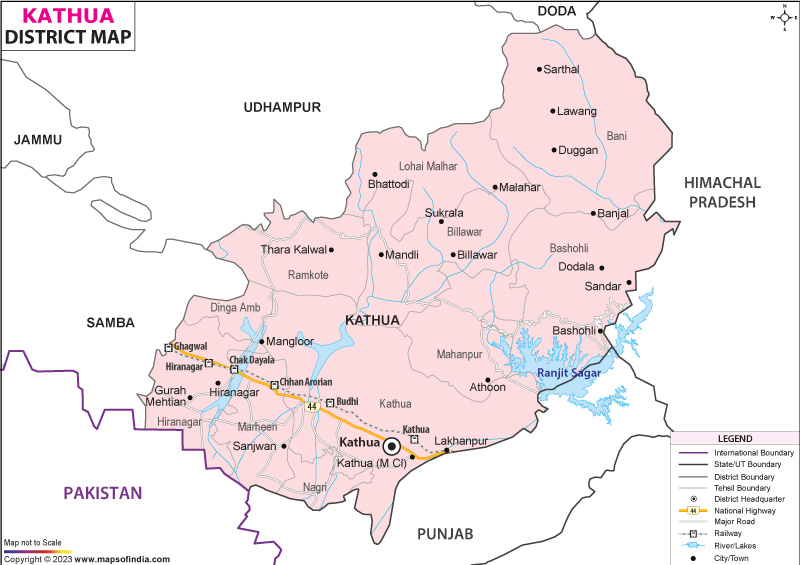
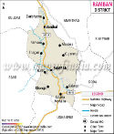
Right where the land begins to rise southward in Jammu and Kashmir, you’ll find Kathua District quietly holding things together between valleys, hills, and the broader country. When people arrive by train or highway from Punjab or slip in through Himachal Pradesh, their eyes meet Kathua before anything else in the region. What they see there - terrain shifting subtly, traditions unfolding - is a quiet preview of what lies deeper inside Jammu and Kashmir. To the northeast, you find Himachal Pradesh hugging the edges of the district. Southeast brings Punjab into view, sitting close along that stretch. On the western and northern sides lie Jammu, Samba, Udhampur, and Doda, each touching different corners. Southwest marks where Pakistan begins, forming a boundary across nations. Spread over nearly 2,502 square kilometers lies Kathua, shaped by sharp contrasts in landform. Flat stretches dominate near the south, especially in Kandi zones, rich and open for farming. Moving northward, the ground lifts sharply into rugged crests dusted with snow - part of the Sivalik range. Places such as Bani and Basohli rest beneath these high shoulders of the lower Himalayas. Called the Gateway, the name fits because Kathua lets trade, travelers, culture, even defense move into place.
History & Culture
Deep in the stories of Rajput clans, Kathua finds its beginning. Long ago, about two thousand years back, a respected warrior called Jodh Singh left Hastinapur behind. From the Andotra family, he traveled far in search of fresh ground. This rich land drew him in. After his arrival, three villages rose through his sons - Teju, Kindal, and Bhaju each built their own. One took root at Taraf Tajwal, another at Taraf Manjali, the last at Taraf Bhajwal. Close by but separate, they grew together slowly. People began calling the whole area "Kathai" as generations passed. Sound shifted across centuries. Now it is spoken as "Kathua". Back then, long before now, stories from old Greece told about Alexander’s march through lands in 326 BCE - where he met a strong fighting community tucked in the lower ranges near Jammu called the Kathaioi. These writings, like those by Strabo, show how tough these folks were; not easily pushed, skilled with weapons, bold beyond measure when facing foreign troops. Their land? Matches exactly what we see today in the area named Kathua. Out of nowhere, Kathua claims fame as where the famed Basohli painting tradition began. Backed by royalty - Raja Kirpal Pal - the art bloomed between the 1600s and 1700s. This form stands as the earliest branch of Pahari miniatures. Bold color choices hit hard: think mustard tones, rich reds, electric blues. Faces show emotion through large, striking eyes. Shapes follow sharp, clean lines. One odd touch sticks out - jewelry sparkles using actual crushed beetle wings.
Economy
Farming markets and big factories shape the flatlands’ work life, while up in the hills, people tend animals, grow fruit trees, or manage woodlands. Economy here shifts depending on terrain - no single pattern holds across villages.
Government Sector
Out of all employers here, government jobs stand tall - offering steady paychecks that anchor household budgets across neighborhoods. Stability flows through these roles, quietly shaping how towns grow from one year into the next. Most people here work in government offices. Some serve at the District Secretariat; others find roles through PWD. The Power Development Department hires many too. Jobs also come from Jal Shakti, keeping hands busy. Across these branches, employment spreads wide. Not just one place, but several draw workers in. Each office holds its share of daily effort.
Public Sector
Fed by mountain streams, Kathua draws major government spending into massive construction efforts. Because of strong road networks, development pushes forward near river valleys. With reservoirs nearby, engineers tap flowing water for regional power needs. Where railways meet highways, new hubs begin shaping up slowly. Near these junctions, progress grows without much noise. High up near the Ravi River rises the massive Ranjit Sagar Dam, known also as Thein Dam. This large government-built structure produces power through flowing water. Instead of burning fuel, it relies purely on river movement. Irrigation reaches farmlands downstream because of its reservoir. Hundreds find work here - not just engineers but many hands managing systems and daily tasks. Though quiet in operation, its presence reshapes both landscape and livelihoods.
Services Sector
Out here in Kathua, more people are working in service jobs now than before. Growth comes not just from city expansion but also movement of goods through the region. Money systems evolving add fuel too. What you see is change shaped by flow, cash, and space turning busy. Deep in the region’s economy, a mix of state-run, independent, and member-owned banks keeps money moving. J&K Bank, alongside giants like SBI and PNB, ties everyday commerce together. From villages to cities, these lenders support transactions quietly, steadily. Each branch plays a role - no fanfare, just function. Money flows because layers of trust back each deposit, each loan. Behind small trades and large deals alike, this system runs without pause.
Tourism
High up, green fields stretch far across Kathua's hills, while old stone temples sit quietly below. Water fills wide basins carved into the land, standing still under open skies. Instead of crowds, there are paths that lead through cool grass and ancient walls warmed by sun.
Natural Attractions and Hill Stations
Bani Valley hides high above four thousand feet, tucked beneath thick stands of oak and pine. Not quite Kashmir, yet people say it feels like it. Streams rush through without stopping, cutting across soft green meadows.
Water and adventure tourism
Water glistens where Basohli once stood quiet, now bordered by the broad stretch of Ranjit Sagar Lake. Behind its calm surface lies a transformation - this place used to be just hills and old stone paths. Today, motorboats cut sharp lines across the bright blue waters instead. Adventure rides on waves powered by machines rather than silence broken only by birds. Parasails rise above like kites caught in steady winds while jets skim fast near shorelines. Development arrived without warning, reshaping what people remember about this land. Over the waters of Ranjit Sagar Lake rises Atal Setu, a bold 592-meter span held by steel cables. This modern structure links Basohli straight through to Dunera in Punjab. Visitors often stop here when light fades, drawn by views of the sun dipping behind the water. Its design turns heads, not just for function but for form too.
Historical and Religious Landmarks
Pilgrims climb up to Sukrala Mata Shrine, perched quietly on a green hill close to Billawar. This sacred place holds deep respect across the region. The site honors Mal Devi - seen by many as an earlier form of Goddess Sharda. Crowds gather each year when Navratra brings color and rhythm through prayer and song. Thousands walk these paths, drawn not just by faith but by something older than words.
Demographics
Back when the 2011 Census counted heads, it found 6,16,435 people living there - quite a chunk for the region’s numbers. Out of those, men made up 3,26,109 while women stood at 2,90,326. When it comes to running things locally, Kathua helps steer both economic flow and governance tasks. Females in Kathua district number 890 for every 1000 males, falling short of India's overall figure. A look at this gap shows how gender distribution and local realities have shifted through time. Each new census reveals subtle changes in the makeup of the population here. Picture this: just under two out of three people in Kathua can read and write, a sign that schools are slowly making headway here. While most men - over four in five - have learned their letters, fewer women have had the same chance, barely crossing the sixty-three percent mark. That difference? Around seventeen and a half points separate them. Behind the scenes, officials keep pushing lessons and learning as something worth protecting.
Language and Religion
Most people here speak Dogri first, about eighty-two percent, especially where the land flattens out below. Up higher, among those who tend flocks or live along steep slopes, you will hear Pahari - close to seven percent - and Gojri too, at three and a half. Most people here follow Hinduism - that comes to 87.61 percent. Next in line, Islam holds space for 10.42 percent, especially seen in areas like Bani, Lohai-Malhar, and Basohli. Following behind, Sikhism stands at 1.55 percent, mainly found where towns meet trade routes. Then come Christians, Buddhists, and Jains - each a tiny piece of the whole.
Administration
Deep in the valleys and along busy trade routes, Kathua's system keeps things running without fuss. Leading it all sits a single officer wearing three hats - one name on paper, different titles depending on the task at hand. Eleven Tehsils shape how Kathua runs things like local rules, property tracking, or keeping order. Each part helps manage duties in its own zone instead of one big center handling everything at once: Kathua (Tehsil Headquarters),Hiranagar,Billawar, Basohli,Bani, Nagri,Barnoti, Marheen, Dinga Amb, Mahanpur, Lohai-Malhar. Buried under that level, you find 19 Community Development Blocks handling cash for countryside growth and small-scale building efforts. Each one takes charge of its own patch, guiding where money flows without waiting on higher-ups. Out in Kathua, village-level organization stretches wide to manage country areas. There are 512 separate revenue villages tucked into the landscape.
| Official Name | Kathua |
| Location | Jammu- Kashmir |
| Area | 2502 sq. km |
| Population | 616435 (2011 census) |
| Language | Pahari , Gojri |
FAQs
Q1: Around how many villages exist within Kathua district?
One way to look at Kathua is through government data showing 512 revenue villages tucked within its borders.
Q2: What is the Population of the District ?
Every thousand men in Kathua means there are 890 women living nearby. The area's full headcount hits 616,435 people when counted by census teams. Among them, 326,109 happen to be male. Females make up the rest - 290,326 in number - who complete the overall picture drawn from official records.
Q3: What is the Kathua District Known For ?
Famous everywhere, Kathua stands out because of its well-known traditions, alongside distinctive landmarks, also shaped by long-standing cultural roots. Arriving here feels like stepping into a threshold - this place links Jammu and Kashmir directly to the rest of India, not just by road but through.
Last Updated on : July 21, 2026
