






About
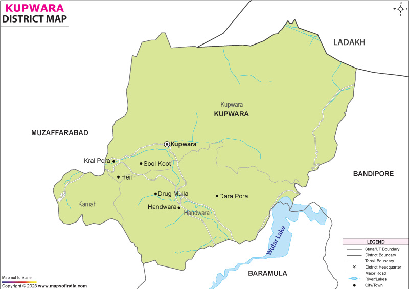
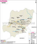
High in the northern reaches of India's Jammu and Kashmir lies Kupwara, a region shaped by both nature’s force and quiet importance. Formed in 1979 when boundaries shifted from the old Baramulla, it took its identity from the central town bearing its name. Positioned near the outer edge of the Kashmir Valley, it rests at about 5,300 feet above sea level - neither low nor high, yet distinct. To the north and west stretches a guarded border, nearly 170 kilometers long, dividing it from areas under Pakistan’s control. Southward, without a sharp break, it merges into what remains of Baramulla.
Though quiet in appearance, the zone functions as a key natural habitat while also linking distant northern areas to Srinagar, some 110 kilometers south. From above, the terrain appears unbroken by roads or cities; instead, forest stretches dominate without interruption. Its role goes beyond nature - movement through here shapes access for regions otherwise cut off during winter months. Distance does not weaken its relevance; rather, isolation increases how much it depends on these connections.
History & Culture
Throughout time, Kupwara has moved alongside the larger story of Kashmir, serving as a passage - now for traders, now for wandering groups, now for seekers following old mountain paths woven between the Hindu Kush and the Himalayas. Centuries ago, remote areas such as Karnah, Lolab, and Keran held their own rhythms, guided by village leaders or drawn under distant thrones - the Maurya expanse, then the Kushan realm, followed much later by sultanates and imperial courts beneath domed tents. Only in 1979 did boundaries shift on paper; governance required division, so the highland edge broke from Baramulla to stand apart.
Among those residing in the district, ethnic Kashmiris form the majority. Yet, the far reaches near borders host active Pahari and Gujjar populations. Within such diversity, culture unfolds uniquely - Sufiana melodies exist without tension beside ancestral Rouf performances. Meanwhile, energetic Pahari tunes travel across time, preserved by family lines.
Here, the land holds traces of lasting balance - Sufi shrines near age-old temples, standing without fanfare. As Eid unfolds or harvest time draws close, meals emerge: rich, shared platters that speak more than words ever could. These gatherings do not announce themselves loudly; they simply continue what has always been done. In each gesture around the table, something unspoken passes between neighbors. The way food moves from hand to hand reflects patterns older than memory. Quiet moments at these events carry weight. What remains visible is not performance but habit shaped across generations.
Economy
Mountain slopes shape much of what happens here. Instead of factories, fields define daily work and income. Forests contribute as much as farmland to household livelihoods. Because roads are limited, the movement of goods faces frequent delays. Border proximity restricts industrial growth yet supports cross-trade traditions. Orchards occupy valleys where wheat once grew in abundance. Services grow slowly, influenced by regional access challenges. Water sources feed crops more than machines. Old patterns remain strong even as new markets appear quietly. Terrain decides production choices across villages and seasons.
In Kupwara, governance structures form a core element of structured job provision and systemic consistency. Due to its location near national boundaries, many residents find roles in state-run offices, schools, and medical centers, alongside bureaucratic frameworks. Instead of private enterprise dominance, military installations, frontier security units, and construction corps shape economic rhythms through sustained spending patterns. Because of this concentration, publicly funded activities support major construction efforts, countryside work programs via MGNREGA, along with regional uplift plans - each channeling resources directly into village-level trade networks.
Among institutions shaping Kupwara’s landscape, those operated by the government stand out. Not limited to services alone, these include banks backed by national policy, along with cooperatives focused on farming needs. Instead of private dominance, access to funds flows largely through Jammu & Kashmir Bank and similar outlets. Because rural livelihoods depend on seasonal inputs, such financial channels matter deeply. Support arrives not as charity but as structured lending, reaching growers of apples, grains, and minor crops alike. Beyond finance, oversight extends into wooded areas where state entities regulate harvests. Rather than unchecked removal, tree cutting follows planned cycles meant to preserve ecological balance. From these forests come materials used locally - fuel, construction supplies, raw stock for artisans. Revenue returns to public accounts, funding further development work across the region.
In Kupwara, movement within the service economy gains momentum, driven not only by shop-based commerce but also by freight handling across rugged terrain. Because it serves as a primary marketplace for numerous nearby rural areas, activity clusters in urban nodes like Kupwara Town and Handwara, where storefronts multiply alongside delivery fleets navigating steep routes. Alongside physical infrastructure, intangible offerings rise - learning hubs run privately, medical outposts appear incrementally, while phone-linked utilities reshape access patterns. Behind these shifts lies a subtle transformation: outdated structures give way as data pathways and personalized support systems take root slowly. What emerges is less a sudden leap than a steady reweaving of daily function into more connected forms.
Tourism
Kupwara waits beyond the well-trodden paths, a quiet stretch of land shaped by silence and height. Few arrive here; most pass on toward busier valleys, leaving behind trails that wind through unshaped hills. Where others see only distance, there are clearings wide enough to lose oneself, thick forests holding ancient rock shelters. The air carries weight differently at this edge, sharp yet soft when sunlight slants late into dusk. Not many speak of it, which keeps its streams cold, its fields unnamed.
Lolab Valley holds clear prominence within the region. Across a wide stretch of lush terrain, dense deodar woods meet open fields of fruit trees, dotted with traditional wooden homes built in old Kashmiri style. Found here, too, are the intriguing Kalaroos Caves - remnants of antiquity tied closely to stories passed through generations. Mystery lingers around these underground formations, shaped by time and belief alike.
The Bangus valley rests 3,050 meters above sea level. Framed by towering snowy summits, it unfolds quietly under vast skies. Two parts form its layout: Bodha Bangus and Chhota Bangus - each distinct, yet equally remote. Across rolling meadows, thin ribbons of water trace paths through thick green cover. Silence dominates here, broken only by wind, water, or distant animal calls. Far from roads or crowds, footpaths lead deeper into stillness. Those drawn to long walks in untouched regions often find what they do not name until arrival.
Incredible new tourism spots have emerged within the district, such as the Keran and Machil valleys, both stretching alongside the Line of Control. Alongside these areas lies the swift-flowing Kishenganga River, its waters vivid blue under open skies; beyond it rest distant villages visible to those standing near the edge. A sense of quiet pride blends with traces of ancient stories and traditions observed among locals here.
Reaching Karnah requires passage over Sadhna Pass, perched high at 3,130 meters above sea level - its sharp curves revealing wide-open scenes of the Shams Bari peaks ahead. From Sogam’s serene Sufi shrines to Tangdhar’s steep cliff roads carved into rocky slopes, movement through Kupwara unfolds slowly, almost untouched by haste. Time seems held back in this corner, preserving an unfiltered glimpse into life deep inside the Kashmir Valley.
Demographics
High within the hills live most of Kupwara’s people, shaped by terrain more than trends. Recorded during the national count, 870,354 reside here, numbers rising as remote clusters grow. Spread thin across slopes and valleys, over 87 percent call villages home, far from city rhythm. Towns such as Kupwara and Handwara hold fewer, though their presence adds subtle shifts. Reading ability has changed slowly - now at 64.51 percent - with men ahead at 77.10. Women reach books and schools more now, closing the ground quietly, recorded at 54.79. Progress appears where local efforts meet long-standing needs, not through sweeping change. Across the region, speech varies in notable ways; Kashmiri stands as the dominant language, chosen at home by about 71.1 percent of residents. Following closely comes Pahari, present in roughly 14.1 percent of households, while Gujari appears among just under one-tenth of inhabitants. Elsewhere, Urdu and Hindi also appear regularly, shaping daily interaction. Such layers form an environment where multiple heritages coexist through voice.
Administration
Spread across difficult terrain, Kupwara relies on an administrative setup meant to extend oversight even to remote edge areas. To bring order to local management, several Tehsils divide the region, each overseeing clusters of villages linked through a broad rural grid.
Among those influencing governance structures are the main Tehsils. These subdivisions play a role in organizing regional oversight. One finds them central to local management frameworks. Their presence supports structured civic operations. Each contributes differently to district-level coordination.
Among the region’s features lies a count of 362 officially acknowledged census villages, grouped within 356 Gram Panchayats. From expansive farming lowlands such as Kalarooch and Hayihama, settlement patterns shift toward isolated highland outposts near frontiers, where snow isolates communities through prolonged cold seasons. Oversight from central offices demands tailored strategies due to geographic extremes. Each village cluster reflects distinct logistical needs shaped by terrain and climate.
| Official Name | Kupwara |
| Location | Jammu and Kashmir |
| Area | 2739 sq. km |
| Population | 875,564 |
| Language | Kashmiri, Hindi |
FAQs
Q1: How many villages are there in the district?
There are 363 villages in the district.
Q2: What is the population of the district?
The population of the district, according to the 2011 census, is 875564.
Q3: What is the district famous for?
Kupwara district earns global recognition as the "Walnut District," delivering more than 50,000 tonnes of fine walnuts every year. Yet another reason it stands apart lies in its unspoiled natural beauty - places like Lolab Valley reveal landscapes of rare calm. Beyond that, the elevated pastures of Bangus Valley unfold views shaped by altitude and quiet. While nuts define its output, terrain defines its aura.
Last Updated on : July 17, 2026
