






About
Located in the heart of the Kashmir Valley, the town of Budgam is situated between Srinagar and the Western Mountain range of the Jammu and Kashmir Union Territory in the Kashmir area. The district got its name from the town of Budgam, where administration takes place. The surrounding countryside is also varied with fruits and flowers, meadows, marshes, woods, snow-covered hill clusters and a panorama which is constantly changing with the passage of the seasons.
In present times, the Budgam area is considered to be a crucial district of central Kashmir. The traditional role of agriculture is also very strong in daily life, and education, tourism and public services are part of the contemporary identities of agriculture. An observer of the Budgam district map can readily come to know that it's a district with a unique position in the social, cultural and economic scenario of Jammu and Kashmir.
History & Culture
History in Budgam is not on a linear path. It takes the form of a cloud that enshrouds a valley, from layer to layer.
It has been inhabited for centuries and has seen the rise and fall of several dynasties ruling over Kashmir. Over the centuries, it was marked by the presence of ancient Hindu kingdoms, the Shah Mirs, Mughals, Afghans, the Sikhs and the Dogras who left their impressions on its topography and consciousness. In all these shifts and stages, Budgam kept its affinity towards the political and cultural practices of the Kashmir valley.
Charar-e-Sharief is a district's popular historical centre and one of the most honoured Sufi destinations of Kashmir. The Nuruddin Noorani shrine is known as the shrine of Sheikh Noor-ud-Din Noorani or as he is called, Nund Rishi, who was the preacher of peace, spirituality and communal harmony.
Budgam's culture is interwoven with its Kashmiri heritage. There is a continued significance of traditional music, folk songs and local histories. They have beautiful customs that are observed during marriages, and there are heirlooms worn during their festivals and social events.
Another such powerful cultural indicator is the language. The broad use of Kashmiri is widely used throughout the District, whereas Urdu is used for administration and education purposes. Gujari is used as a language among some Gujjar populations as well.
The district is vibrant and colourful during festivals in specific seasons. There are masses of religious activities aligned with Islam; cultural activities featuring local traditions, craft and food. The traditional dishes and the call and sound of the 'Budgam' folk music, and the warmth of the people have certainly made this ‘Budgam' altogether.
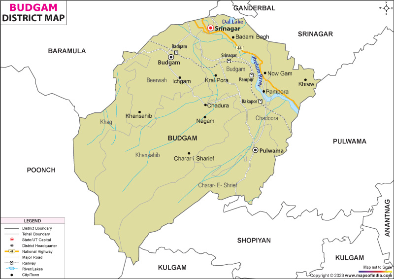
Another interesting thing is shown in the Budgam district map as diversity within unity on the local level. Though there are distinct customs and traditions in different villages, they are united in a common Kashmiri identity. One of the district's strengths is the cultural continuity.
Economy
The economic situation in Budgam District is like a carefully woven tapestry. It is based on Agriculture but has several contributing industries for growth and jobs.
An agricultural process is evident in the fertile plains shown on the map for the district of Budgam. Domination of the rural landscape by paddy cultivation with the production of maize, vegetables and pulses. Significant role is played by horticulture, fruit crops including apple, pear, cherry and walnuts, generate incomes for Households, regional economy is partly involved in horticulture trading.
Many families in rural communities rear livestock, which also gives them another income source. In addition to agriculture, the farming of dairy products, sheep and poultry helps to sustain farmers' income and livelihood.
Government Sector
The government sector is a major employer in the Budgam district. A variety of administrative offices, educational facilities, health care facilities and development departments offer significant job prospects.
Socio-technical efforts by the government reaffirm infrastructure, road connectivity, irrigation infrastructure and public welfare services. The district administration is an important player in implementing development schemes aimed at improving the livelihood of the rural people and their social welfare.
Public Sector
The public sector institutions make a major contribution to economic development. Public health care centres and schools, technical institutions and infrastructure projects provide jobs and benefits quality of life.
More investments in transportation, rural development and public utilities have improved economic activity in the various sections of the district. This is particularly significant for the remote communities and access to key services.
Services Sector
In recent decades, the growth of the services sector has been steady. New industries represent a larger and increasing portion of jobs and these include education, health care, and retail trade as well as transport and tourism-related services.
The market linkages and trade increased and trade activity intensified with the proximity of the district to Srinagar. Local jobs are crucial and make a significant contribution to local incomes, such as in shops, transport, hospitality and small businesses.
Tourism has become one of the most significant elements of the services economy. As more visitors come to an area on the Budgam district map, more job opportunities will arise for guides, hoteliers, transport and local craftsmen.
There are also the traditional handicrafts which contribute to the income of families. Craft traditions like weave carpet making, embroidery, wood work showcasing the art of Kashmir and provide livelihood facilities to the local people.
As a whole, the economy of Budgam district is a combination of traditional occupation and services and this makes the domain of a varied structure of the economy more capable for long term development.
Tourism
Budgam district tourism is like entering a field of amazing, beautiful pictures; each turn will reveal a new one. On the Budgam district map, there are places that are so special that they serve as a destination for pilgrims as well as for those who love nature and adventure.
Another important tourist attraction is Doodhpathri, also known as the "Valley of Milk". The obvious beauty of the clear water in the creeks, grasses and mountain views is an unindescribable scene. It is a holiday destination for picnics, trekking and photography.
There is a growing awareness of the joys of Tosa Maidan amongst nature lovers. This is a huge meadow with a sweeping vista of the area's surrounding mountains that are historic and breathtaking. The Budgam district map often attracts travellers interested in exploring this spectacular destination.
The beauty of Yasmarg is one of Kashmir's gems, and it is very much under the radar. It has plenty of trees and rolling meadows, and is surrounded by trees with amazing views and a relaxed environment. Now, the Budgam district map can certainly assist someone if they want to know further about anything related to Yusmarg.
Another of the religious centres, named Pakherpora, has a shrine and religious importance. People from all over J&K are coming to visit there throughout the year.
The district is home to wetlands as well, which contribute to the district's tourism experience. By also hosting migrant birds and bird-watchers at various times of the year, Hokersar Wetland is partially located within the district's influence zone. The ecological richness of the district is evident in the Budgam district map that shows the rich environment of the district.
As treasure trekking and hiking, along with outdoor recreation, become more popular in the country, their benefits are also beginning to attract people with interests in adventure tourism. Forest trails offer good possibilities for forest exploration, as do mountain trails and alpine landscapes.
Every place has its own tourist story for the district. They form a spiritual travel experience characterised by nature's beauty and cultural richness.
Demographics
The Budgam district is one of the most populous districts in the Kashmir Valley. The population of the district was 753,745 as per the 2011 census. The village population is dominant, with a considerable proportion in villages throughout the district.
Over the years, the high literacy rate has made a significant improvement. The situation with regard to literacy rate has improved since it was put at some 69.50 per cent in district administration statistics.
The main language of the District is Kashmiri. Urdu is a language used extensively for official and educational functions. The Gujjar people also speak the Gujari language and this also gives some diversity in language to the district.
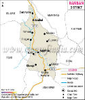
The Budgam district map illustrates the distribution of settlements in the fertile plains, the foothills and the mountains. This geographical diversity is reflected in the differences in local life and living.
Administration
Budgam district has an accepted administration that is able to cover both urban areas and rural areas. Today, the District Administration reports that there are 9 tehsils in the district of Budgam. These include Budgam, Beerwah, Chadoora, Charar-e-Sharief, Khag, Khansahib, BK Pora, Narbal and Magam.
The Budgam district map is a potent administrative help and enables the identification of the tehsil boundaries, transport networks and settlement patterns. According to records of the Government, the district has 504 villages.
Various departments that have responsibility for revenue, rural development, education, healthcare, agriculture and infrastructure are responsible for administrative duties. Panchayats and local bodies have a critical importance in the process of grassroots governance and community development.
The district map is still used as a basis for District planning, development and resource management. The Budgam district map is particularly beneficial for district administrators, researchers and travellers as it offers a thorough understanding of the geographical arrangement of the district and its organisation. Biodiversity is one of the major things that are represented in the Budgam district map, representing the intermingling and interplay of nature, culture and administration in the key district of Budgam in the state.
FAQs
Q1: How many villages are there in Budgam district?
Budgam district has 504 villages according to the District Administration records.
Q2: What is the population of Budgam district?
As per the Census of 2011, Budgam district had a population of 753,745.
Q3: What is Budgam district famous for?
Budgam district is famous for Charar-e-Sharief, Yusmarg, Doodhpathri, Tosa Maidan and its rich Kashmiri cultural and spiritual heritage.
Last Updated on : August 21, 2026
