






About
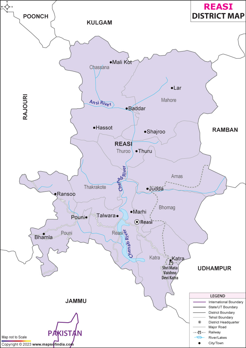
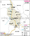
There are districts that expose themselves at an instant and then, there is Reasi. It is surrounded by rugged mountains, meandering rivers, lands where legends must have been woven of ages past in time, sitting in the Jammu division of Jammu and Kashmir, like a chapter of a drama waiting to be unfolded. The district was named after Reasi, a historic town which had been an important regional administrative and culture center since long. The topography of the Reasi district is indicated on the map and is made up of hills, valleys and river systems, which formed the land over thousands of years, and have had a significant impact on the development of the settlement, trade and defence of the area.
Reasi district is located in the North-West of the city of Jammu and is adjoining to the other districts of Jammu and Kashmir. It is a strategically important area between the plains of Jammu and the high altitudes. It is a widely recognised fact that the district is famous for the sacred Shrine of Vaishno Devi, which is one of the most visited pilgrimage sites of the country. It represents a major route for the pilgrimage and is marked on the Reasi district map as an important link between the millions of pilgrims and the holy shrine of the cave yearly.
The district was established in 2006 as a unit of administration. From this time, it has developed into an important attracting centre for devotional and religious tourism, hydroelectric power development and as a regional administration and control centre. Its national importance has been further enhanced by major railway works (and other modern infrastructure projects) carried out in this region of the country. The Reasi district map thus signifies more than simply administrative boundaries, but also a space where faith, history, nature and development converge in astounding ways.
History & Culture
Reasi is a story that has encompassed many generations. Collectively, the parts of the district have a historical linkage with the early settlement of the early regions of the Himalaya foothills, where kingdoms existed in those areas. This area saw the rise and fall of various local leaders, tribes and dynasties vying for control of vital trade routes between the plains and mountain regions.
One of the most significant historical landmarks is Bhimgarh Fort, also known as Reasi Fort. The fort is located on a hill, and has been the scene of invasions, political changes and rulers. It was constructed and reconstructed at various times and used as a fortress and seat of administration. Looking at the fort in the background of the mountains makes it almost like a scene from a film; it seems that it was captured in a dramatic moment in history. The location of this can be easily traced from the Reasi District map and still one of the important heritage sites in Reasi District.
The rule of the Dogra left an imprint of its administration, architecture and cultural tradition in the district. In the 19th century, the area gained political integration as the princely state of Jammu and Kashmir. Roads grew with administrative and military establishments of this area, connecting with adjoining regions, increasing its linkage.
The religion has been a part and parcel of the identity of the district since the beginning times. Reasi has literally become one of the most renowned spiritual hubs of India as a result of Vaishno Devi visits. Millions of people pass through the district annually, making it a rich cultural region with an ethos of faith, trade and hospitality blending together. The Reasi district map indicates that Katra is not only a district town but also a city of great importance in terms of the range of its activities, achievements, and interests.
Local customs, including traditional dress, folk crafts and local food culture, add to the richness of regional culture. Local crops of grain, pulse and dairy products continue to play a vital role in the community's life. Rural fairs connect individuals from various areas and develop energetic festivities where trade, fun, and cultural exchange all take place at the very same time.
The cultural interactions are seen in the Reasi district map even today. These landscapes have been traversed by mountain people and religious pilgrims, traders and travellers for many centuries, and past uses have left traditional ways that continue to influence the district's unique character.
Economy
The traditional livelihood and modern development initiatives are being combined in the economy of Reasi district. The livelihood activities like agriculture, rearing of livestock, tourism and public-sector contributes to economic development.
The government has invested vast amounts in infrastructure and roads, education and public services in the district since its inception. Numerous administrative centres have been highlighted in the Reasi District map as places where public service delivery is seen to take place.
The public sector has a particular significance with respect to the development of the hydropower resources. Large scale hydropower generation projects have been taken up in the Chenab basin. These provide jobs for local engineers, builders and technical service providers and generate energy for the region. Other economic benefits of hydro development include transport and trade within the area.
Agriculture dominates the workforce, with a significant portion of workforce. Crops such as maize, wheat and paddy are grown by farmers based on the climatic conditions of the area. There is also a growing interest in horticulture; fruits and vegetables are also a source of household income. Agriculture is the main source of livelihood in many rural areas, as indicated in the Reasi district map.
The rearing of livestock is the other important economic activity followed. Income generation and nutrition are provided by cattle, goats and sheep to the rural householders. In some places (in places with high elevation), pastoral practices still continue as a seasonal practice, e.g., during the dry season in the higher elevations of the district.
The sector of services has made great progress, mainly because of religious tourism. There is a steady flow of pilgrims to visit Vaishno Devi, which brings benefits to hotels, guest houses, restaurants and transport services as well as retail outlets. Katra has grown to be a strong service-oriented economy, with investment and job creation.
The district's economy has further diversified with the emergence of tourism-related services, banking, education and healthcare services. With the development of the infrastructure, Reasi is likely to become a major economic and tourism centre in the state of Jammu and Kashmir in the future.
Tourism
Reasi Tourism is a perfect amalgamation of spiritualism and historical, and natural beauty. On every trip across the district, it is as though a series of dramatic scenes had been played out one after another.
The most popular destination is to visit the shrine of Vaishno Devi in Katra. The shrine is a revered place in India, with millions of pilgrims visiting every year. This pilgrimage route is the most important tourism route of the Reasi district on the map of the district.
Katra is itself a very important tourist centre. In addition to its religious significance, the town also provides lodging, retail and cultural opportunities to visitors from all over the nation. Bhimgarh Fort is another highlight of the destination. Looking over the town of Reasi, the fort has views of the surrounding countryside.
Rivers, hills and forests are laid out across the area, and are appealing to nature lovers. The views and rural landscape create a more relaxed experience alternative to the more popular pilgrimage centres. The Reasi district map for the region indicates the presence of many places that can be visited to enjoy nature without any distractions from society.
The Chenab Rail Bridge is one of the modern attractions of the district, which is the world's tallest railway arch bridge. This engineering marvel has made Reasi famous around the world. Its impressive height above the banks of the Chenab River represents the rise of the district to being an integral part of India's infrastructure development narrative. Visitors can experience Reasi and live in a memorable way, either for spiritual fulfilment, historical exploration or natural beauty.
Demographics
The population in the Reasi district, as per the Census of India 2011, was 314667. Over the past 10 years, the district experienced a positive growth trend in its population. The rural community's population is still mainly rural, with villages having a large proportion of its population.
The overall literacy rate of Reasi district was 58.15 per cent. The percentages of the male and female populations who are literate were 68.38 per cent and 46.59 per cent, respectively. While the educational status of the people has historically been low compared with some surrounding districts, literacy building techniques have gone on with the help of the government's work, as well as the growth of education in its premises.
In the district, other languages besides English are spoken, which are Dogri, Gojri, Hindi and Urdu and Pahari varieties. These languages are representative of the district's cultural diversity and historically of interactions between various groups of people.
Administration
Reasi district is one of the important administrative units of the Jammu division in Jammu and Kashmir. The district headquarters is in Reasi town.
According to the administrative records of the Census-2011, the district is mostly comprised of two tehsils, Reasi and Gool-Gulabgarh. These were the main census tehsils in the district, although later on, the district was restructured over time.
About 346 villages are inhabited in the district that are spread on mountains, in valleys and in rural settlements. These villages are the backbone of the development activities of the rural areas and administration. The Reasi district map is a good representation of the widespread settlements in difficult geographical areas.
District and tehsil offices, local governments, Block development offices and local governance institutions are used to undertake the administrative task. The Reasi District Map is a very important planning document for the government, infrastructure and service provision in Reasi.
FAQs
Q1: How many villages are there in Reasi district?
Reasi district has approximately 346 inhabited villages according to Census 2011 records.
Q2: What is the population of Reasi district?
The population of Reasi district was 314,667 as per the Census of India 2011.
Q3: What is Reasi district famous for?
Reasi district is most famous for the Vaishno Devi shrine, Shiv Khori cave shrine and the iconic Chenab Rail Bridge.
Last Updated on : July 21, 2026
