






About
There are locations that become apparent at first sight. There's Ganderbal. Appealing at first sight. Mysterious upon approach. Unforgettable once understood.
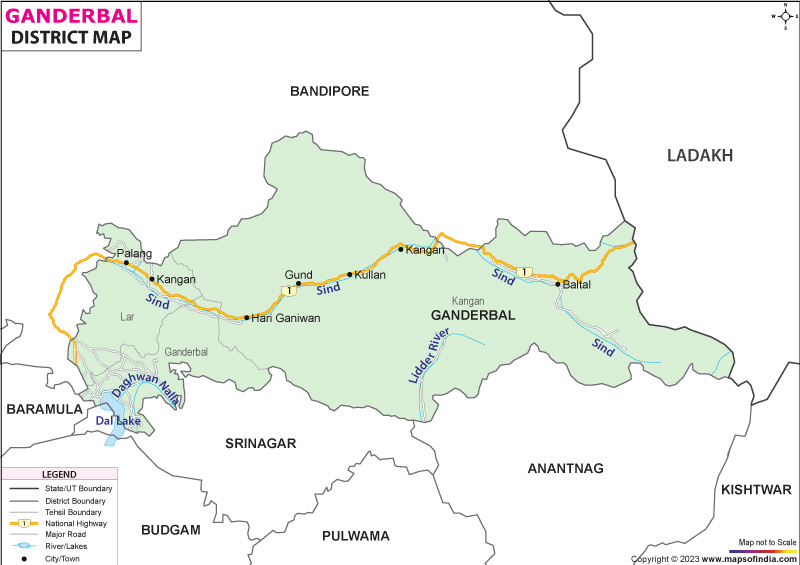
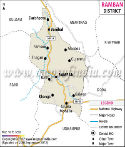
Pursuing the main aim of better administration and development, granting the Ganderbal district a unique identity has been influenced over these decades. Ganderbal district is located at the centre-most portion in reach of the Kashmir Valley & has gradually gained significance. Established to be a district in its own right since 2007 and covering the north-east of Srinagar, this can also provide massive access into high altitude landscapes within central Kashmir. The Ganderbal district map shows that the location of Ganderbal is best positioned between tourism, agriculture, and regional connectivity.
The geographical location of Ganderbal is not what makes it unique. The routes for pilgrimage go through it. It's the setting for historic traditions. It continues to be developed to this day. In any valley, one finds a story. Each and every mountain seems to protect a secret of its own.
The Ganderbal district map is therefore more than a simple administrative map. It embodies a place where histories, tangible matter, faith, and people's strength and determination meet in a captivating tale.
History & Culture
It is impossible to talk about the history of the valley of Kashmir without referring to its role as a way of travel to and from ancient Kashmir routes, which passed through what is now Ganderbal. These valleys were used by traders, pilgrims and travellers on their journey towards Ladakh and the central Asian regions. The Ganderbal district map often shows this strategic location in this manner, as it maps various cultural spheres of the Himalayas.
This region was influenced by the Hindu rule, Buddhist principle, Muslim rule and the Dogra rule from time to time. Different eras have influenced the local culture differently. Fragments of these are still in existence and are being maintained by temples, shrines, folklore, and oral traditions.
The district has a strong sense of identity with regard to religion. Though the neighbourhood of Charar-e-Sharif is outside the district, the impact of Sufi traditions of Kashmir can be seen everywhere in Ganderbal. Numerous mosques, shrines, and gatherings of religious character testify to the long-lasting importance of spirituality in people's lives.
The traditional way of life is consistently well preserved in remote settlements, as highlighted in the Ganderbal district map. Though modern influences have arrived in these villages, handicrafts and native arts and culture still thrive.
Kashmiri language and literature are in centres of local society. Narratives are still alive and legends are handed down from generation to generation with regard to mountains, rivers and sacred places.
Consequently, the culture of Ganderbal is not an antediluvian one. It is an ever changing representation of the civilisational age of Kashmir.
Economy
Ganderbal district is primarily dependent upon agriculture, government jobs, tourism, trade and service oriented jobs. The traditional activities and new opportunities in the district contribute to its economic nature.
The agriculture sector is still the key economic contributor in the area. Paddy, maize, vegetables and different horticulture crops are grown on fertile river and stream lands. Fruit and tree orchards and other plantations are a significant source of rural income. The agriculture sector remains an important sector for the district development process.
The Government Sector is one of the biggest employers. A large number of people are working in the district administration, educational institutions, healthcare services, public works, etc., and in different government bodies. Since their establishment, the district has experienced continued administrative development which has further broadened employment opportunities for the public.
There are also indirect ways in which the Public Sector can participate in economic activity, such as building infrastructure, erecting irrigation facilities, and developing rural projects, and welfare schemes. Road investments, public services and connectivity have increased economic interlinkages between various parts of the district.
There is also a significant local economy based on services, the majority of which are related to tourism. The visitors travel to Sonamarg and other local tourist attractions, aiding the business of hotels/guesthouses, transport operators, tour guide and small businesses. A major quality of Ganderbal could be said about its role as a gateway to significant tourist routes, as observable on the Ganderbal district map.
In these towns, like Ganderbal and Kangan trade and commerce are considered due to the surplus funds. Trade and commerce exist prosperously in Ganderbal, Kangan and other towns with surplus funds. The local population and tourists are served by retail markets, transportation services, and small businesses. Behaviour in businesses alongside tourism is skyrocketing during the peaks.
Other major areas of employment that have been highlighted are human services and education. Professional opportunities in schools, college or medical institutions, along with an enhanced social development.
Overall, the Ganderbal economic base embodies a mix of an agricultural base, public workforce and developing a tourism sector as well as developing the service sector.
Tourism
The tourism that's established in Ganderbal is like a painstakingly compiled film masterpiece. The game is played out in scenarios, and a new turn is added with a new scenario. Each valley comes with a mystery.
Thajiwas Glacier remains one of the most favourite natural attractions of the district. It can be accessed from Sonamarg and is also truly breathtaking to watch the glacier in the summer, where the snow still blankets the landscape.
The district is also enhanced by the introduction of the Sind river which adds more beauty to the district. It's a rush flow down valleys, and at settlements for fishing, taking photos and viewing sights. The river sometimes appears to be one of the most prominent geographical aspects of the district and for this reason, it is often featured on the map of the Ganderbal district.
There is also a Historic site to be visited in Naranag. The Naranang Temple Complex is a collection of ancient temples, dating back to the early medieval period, that is a vast and significant source of stone architecture and is of historical significance for Kashmir. The whole of the Gangabal Lake is an adventurous trail that is going to be a trek for the adventurous. The lake is situated at a higher altitude, just below Mount Harmuk and is quite beautiful, along with spiritual values. Getting there is difficult, but even after so much effort, it's a great reward.
The summit of Mount Harmukh itself controls the sky and is of great value in terms of cultural and religious values. A number of the tracks that go up the majestic mountain possess a witty backdrop. The town of Baltal is of special importance during the yearly pilgrimage to Amarnath. It is a path that thousands of pilgrims have to walk every year to reach the sacred Amarnath cave.
Ganderbal map is a travel guide to visit this unique place of relations and shows the relationship between mountains, lakes, valleys and pilgrimage routes. Ganderbal has some interesting things for photographers, trekking enthusiasts, pilgrims and tourists alike. The district's not a place to be going to. It offers experiences that will remain in one's mind after coming back from the place visited.
Demographics
There were about 297,446 persons in Ganderbal district as per the Census 2011 data. The district comprises diverse communities that make up the social and cultural fabric of the district.
As per the Census 2011 literacy rate of Ganderbal district was about 58.04 per cent. Government programs and the increased scale of educational infrastructure have received significant attention for educational development.
Kashmiri is the language spoken by the majority in the district. Urdu is also a crucial language for administration and education. Apart from that, Gujari is also widely spoken by the Gujjar community and Hindi and English are also understood and used in various official and educational settings.
The district contains both urban and rural residents, but most of the residents live in rural areas. Demographics across villages and settlements are closely tied to agricultural, horticultural and livestock related occupations.
The Ganderbal district map indicates this distribution in population densities, with nuclei of people situated in river valleys and transport corridors.
Administration
Ganderbal district is governed by various administrative and revenue units, which ease governance and service delivery.
The district presently consists of six tehsils, namely Ganderbal, Kangan, Lar, Wakura, Tullamulla and Gund. These administrative divisions facilitate good governance in the district.
According to the official profile of the district, there are 115 villages in the district. These villages are the base of the rural based economy, culture and demography of Ganderbal.
Major administrative functions are coordinated from Ganderbal town, which is the district headquarters. This is the administrative system to oversee development programmes, public services and district-level governance.
The map of Ganderbal district still serves as an important reference map for the spatial organisation of these tehsils and villages. The Ganderbal district map is often used by people like administrators, planners and visitors to navigate and to plan the area.
Moreover, the Ganderbal district map will provide support for infrastructure development and the Ganderbal district map will also identify connectivity between the non-urbanised areas as well. The Ganderbal district map is useful for researchers to view and learn about the localities of the district. The Ganderbal district map is useful in many ways to summarise the administrative geography of the district.
FAQs
Q1: How many villages are there in Ganderbal district?
Ganderbal district has 115 villages according to official district profile records.
Q2: What is the population of Ganderbal district?
According to the Census 2011, Ganderbal district had a population of 297,446 people.
Q3: What is the Ganderbal district famous for?
Ganderbal district is famous for Sonamarg, Thajiwas Glacier, Gangabal Lake, the Naranag Temple Complex, the Sind River and its role as a gateway to the Himalayan landscapes of Kashmir.
Last Updated on : July 17, 2026
