






About
The characteristics of some districts are laid bare at a glance, and there is Poonch. Lying on the path of a formidable Pir Panjal range in the Jammu division of Jammu and Kashmir, this ‘frontier' district is like an intense story languishing behind mountains, valleys and centuries. The term “Poonch” is thought to have originated from the ancient word ‘Panchala’ or ‘Poonchh', which also indicates its historical importance in the north-western Himalayas.
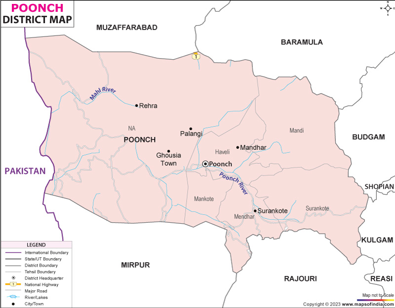
The district is also adjacent to two districts (Rajouri) and the hilly region of the Union Territory (UT) in its western part. When the Poonch area map is closely studied, it is seen that the valleys have been a link between the Kashmir and the plains region in Jammu through a number of high mountain passes.
Poonch district is now an important administrative centre, cultural and economic base of the Pir Panjal region. It is a fusion of history, cultural blending and grandeur that makes it somewhat distinct from the UT of Jammu and Kashmir. Understanding the Poonch district map is essential; it is an important tool for researchers, travellers and administrators.
History & Culture
History echoes in Poonch between mountains and hills. The area long predates the creation of modern state units and used to be part of ancient kingdoms and trade routes, which connected the very Himalayan world with northern India.
Over time, the district was swayed by different dynasties. The Rajput rulers brought regional administration, and there were connections during later periods with the Mughal power. The famous Mughal Road used to traverse the adjoining mountain passes during the Mughal period between the Kashmir Valley and the plains of Jammu. It is noteworthy to see a Poonch map now and know what strategy these routes had in their days.
The district's culture is highlighted with festivals. Eid is celebrated in a religious and social manner. Visitors from nearby come to the traditional fairs. For many people, seasonal celebrations tend to follow the cycle of agriculture, as people are closely connected to the land. The Poonch district map might contain roads and settlement names, but there is much more cultural expression behind every one of them.
Custom clothing, crafts and local food are another aspect of local identity. In colder regions, they still play an essential role in clothing with woollen clothes. Local breads and regional dishes are still part and parcel of daily life, still relying on dairy products. Hospitality is treated with special warmth and the guest is often made a cherished member of the family.
Economy
Poonch district's economy is an example of a mountainous frontier economy. Three sectors – agriculture, government jobs, and trade and services – contribute to livelihoods in the district. The topography affects economic activity on all scales, affecting opportunity as well as constraint.
The government sector is one of the most important sources to employ people. There is a large population who are employed in different departments such as District Administration, Educational institutions, Healthcare facilities, and Security related establishments. Government institutions have a prominent place in providing services to people throughout tough terrain. Looking at the Poonch district map can also help draw attention to the importance of effective administration in such dispersed areas.
The Public Sector contributes in the form of infrastructure, road development, supply of electricity and public welfare programmes. An increase in investment has increased access to remote settlements and has enabled economic activity. There are a number of development projects aimed at improving the livelihoods of rural communities and improving the provision of basic services across the district.
Agriculture is still a significant part of the local economy. Maize, wheat and other crops are grown by the farmers following the climatic conditions of the Pir Panjal region. Horticulture has also increased in significance; in some places, fruits earn a living income for their growers. Livestock rearing is another important activity, especially for the pastoral communities.
The growth trend of the “Services Sector” has been continuous and progressive over the years. Recently, numerous people have been employed in the sectors of education and healthcare, as well as retail trade, transport and communications. Here, small businesses are found in urban centres, providing services to both citizens and tourists of the town, such as Poonch. The Poonch district map reflects the development of commercial centres—a step-by-step development with the improvement of the transportation network.
There is huge potential for the economy in tourism. Unique, naturally gorgeous areas, historical landmarks and cultural assets provide a growth platform. Further improvement in sources of connectivity and infrastructure would strengthen the contribution of tourism to the local economy.
Other important forms of trade are also across regions and local markets. Products such as agricultural outputs and livestock products are sold and traded in trading centres linking farmers with extended markets, alongside consumer goods. The district is still working towards diversifying its economy, but the work still has a long way to go.
In the overall scenario, households in Poonch district are engaged in traditional livelihoods with growing service-oriented activities. The Poonch district map is not only a geographical map but a visual representation of the economic links among the villages, towns and mountain corridors also.
Tourism
The tourism activities in Poonch district follow the flow of a scenic landscape, unfolding the mountains, forests and the historic sites. Each bend of the road is a drama that carries on the district's amazing history.
There is a fort named Poonch Fort, which is among the most important landmarks of the district. The fort was built and extended at various stages in history and hence represents the styles of local rulers and later rulers. They are a place with great memories of the past due to the massive walls and historic architecture. For visitors studying a Poonch district map, the fort is often the hub around which they spin their investigations.
Noori Chamb is another popular tourist destination. It is a beautiful waterfall with local folklore attached to it related to the Mughals. It is one of the most popular places in the district, with water falling through a picturesque landscape in the midst of nature.
Besides that, the Mughal Road itself is an attraction. It is much more than just a transport route; it is a historic path that was traversed by the emperors and travellers between Kashmiri Valley and the plains of Jammu. From this route, you can enjoy a magnificent view of the mountains, connect with centuries of history and travel along a part of this route. The Poonch District map is often useful to highlight these features.
Here, at Loran Valley, nature captivates visitors with its forests, streams and landscape views. In good seasons, the valley is worth appreciating in nature and is a good area to photograph.
Shrines are also places of interest. The area has a number of sacred sites of spiritual significance throughout the district to local communities. The places were chosen because of the richness of their cultural history and the long tradition of religious tolerance in the region.
There are a number of interesting villages that show the traditional way of life and the rural culture of the Himalayas. On the Poonch district map, it is observed that there are several villages hidden among various forests and agricultural terraces, adding to the charm of tourism in the district.
Tourism opportunities continue to be good, thanks to the improvements in infrastructure. History, culture and natural beauty bestow a unique character upon Poonch district, which is not witnessed in other parts of Jammu and Kashmir.
Demographics
The Poonch district has much cultural and linguistic diversity. As per the Census of India 2011, the population of the district was 476,835. Communities are scattered throughout urban centres, small towns and many rural settlements within the mountainous terrain.
In Poonch district literacy rate has been found as 66.74 per cent as per the 2011 census. Schools have grown in number and services and this has helped to enhance the literacy and human development parameters of the district.
Language is significant as a component of the local identity. Also, the district is home to many other languages, such as Gojri, Pahari, and Urdu. The Poonch district map gives an idea of the distribution of linguistic communities throughout the district valleys and settlements.
Geography and population patterns are closely related. Larger populations are found in valleys and accessible areas, with higher altitude areas being more sparsely populated. The Poonch district map gives an idea of these demographic patterns and the influence of terrain on human habitation.
Administration
Poonch district has a complex geographical profile, which is designed to be efficiently governed by the administrative mechanisms of the district. Forest, river and high ridges still separate settlements; this has to be addressed and proper administration is still required.
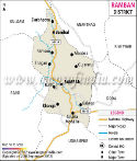
The district is divided administratively into 6 principal tehsils, namely Haveli, Mandi, Mendhar, Surankote, Balakote and Mankote. The Poonch district map gives a clear distribution of these from the various divisions over the district.
Administrative/census records show that there are 178 villages in Poonch district. The size, location and population of these villages can be quite different. Well, some are located in fertile valleys and others in remote mountain environments that can only be reached by twisting mountaintops and narrow roads.
It is the district headquarters at Poonch town which is the main administrative and commercial centre. The greater part of government departments, educational and service centres are located here, for which the wider district provides support. In short, the Poonch district map will continue to be the most valuable map for administration in planning, governance, and resource management across the entire region.
FAQs
Q1: How many villages are there in Poonch district?
Poonch district comprises 178 villages.
Q2: What is the population of Poonch district?
According to the Census of India 2011, Poonch district has a population of 476,835.
Q3: What is Poonch district famous for?
Poonch district is famous for its frontier history, Poonch Fort, Noori Chamb, Mughal Road, cultural diversity and the scenic landscapes of the Pir Panjal mountains.
Last Updated on : July 17, 2026
