






About
There are districts that show themselves at a single look and then there is Kishtwar. It is not just a regular district, surrounded by high mountain walls, set off from low mountain round walls as if with narrow ranges of thin peaks covered with snow; it is like the setting of an emerging epic. Kishtwar is located in the Jammu Division of the Union Territory of Jammu & Kashmir.
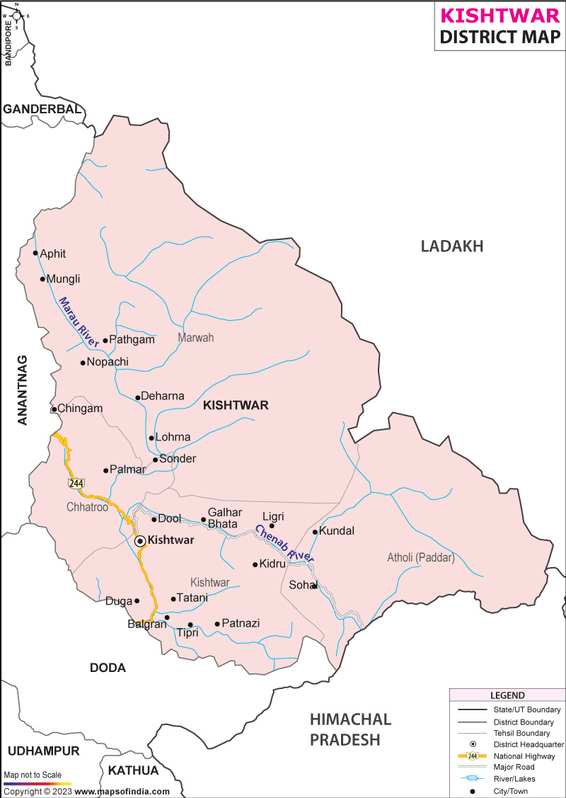
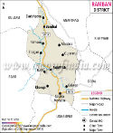
The name Kishtwar is said to be the evolution of a historic region that became an important settlement and administration centre for centuries. The district has become renowned for its outstanding natural diversity, hydroelectric resources, cultural differences and spiritual values today. The Kishtwar district map itself gives a clear idea of the mountainous nature of the district, and the distance valleys up in some parts of the western Himalayas.
Nature, culture, and development are intertwined in modern Kishtwa. In addition to functioning as an example of administrative units, the Kishtwar district map itself serves as an emblem of the biodiversity, historical background, and human resiliency of this region. Kishtwar is not just a part but a bit of a puzzle in the greater puzzle of the development of Jammu and Kashmir, from antiquity till grand schemes of hydro-electricity development.
History & Culture
The tale of Kishtwar goes as far back in history. The region has been part of an extensive valley known as the Chenab valley, which was governed by local chiefs and dynasties until the Dogra kingdom became part of the area during the nineteenth century. Being in the mountain area, it gave it protection and isolation; local tradition and custom thrived in this region even though great political events took place elsewhere.
The district's valleys were once on ancient trade routes that linked communities within the Himalayas. The Kishtwar district map provides a description of why the area was strategic for rulers desiring possession of the passes and river valleys. Over the centuries, Kishtwar has been home to various cultural influences, each adding to the unique heritage of the region without eroding it.
A combination of the communities, languages and beliefs has created a culture in Kishtwar. The old music and folk dances are significant aspects of social activity as well as oral narration, which are still important parts of life here. Seasonal festivals are also celebrated joyfully in the villages, and the religious festivals continue to help develop the bond of the people. The district also has temples, shrines and holy places that are visited by people from all over the region.
Festivities related to agriculture and local customs and religion are among the most noticeable cultural activities. Every year, thousands of pilgrims visit Machail Yatra - dedicated to the goddess Chandi. Then the landscape changes colour; the lengthy mountain tracks become colourful tracts of devotion.
The Kishtwar district map highlights the geographical dispersion of culturally significant valleys – Marwah, Warwan and Paddar that have distinctive traditions and social practices. The geography of the district is reflected in local cuisine, with many ingredients adapted to mountain climates. However, hospitality is still viewed highly as visitors are always met with a strong spirit of community that has flourished through distance.
Economy
Traditionally, the economy of Kishtwar is agricultural, horticultural and ecosystem-based on livestock rearing and forestry. The farming of the mountains is an important livelihood, and inhabitants grow food according to different climatic conditions and altitudes in the mountains. The district is also famous for its saffron crop in some parts of the district and walnuts, rajma and other crop cultivation.
The government sector is a big provider of employment. A significant share of employment is supported by administrative offices, educational institutes, healthcare and development agencies. Many of the government's infrastructure projects have been an important component of enhancing connectivity and public services in the district, especially for areas with more challenging terrain. The Kishtwar district map is frequently used for Planning purposes in road construction, Rural Development and Public Welfare works, etc.
With the development of hydroelectric resources, the role of the public sector has become more important. Kishtwar has tremendous hydropower potential due to its rivers Chenab and its tributaries. The district has become an attractive place for investment, employment and improvement of its economy by large hydroelectric projects. All the projects involved are the biggest infrastructural investments in Jammu and Kashmir and provide for regional energy production.
In the last few decades, the size and importance of service sectors have increased steadily. A variety of new employment opportunities have emerged in education, healthcare, banking, transport and retail trade/tourism activities. With the improvement of communication networks, more and more opportunities are arising for local entrepreneurs and service providers. The Kishtwar district map proves and illustrates how improved accessibility can stimulate economic growth in remote areas.
Another important economic asset is forests. The sustainable utilisation of forest products, together with the efforts of protecting the environment, brings advantages for livelihoods and ecological balance. Tourism, on the other hand, is sought as a sector with immense potential in the long term.
In sum, the district economy is the result of a mixture of traditional livelihoods and development projects. The Kishtwar district map not only shows the physical geography, but it also gives an idea about the various economic zones that help the district to grow.
Tourism
Kishtwar's tourism has a spirit of discovery. Unexpectedly, a dramatic landscape can emerge around the curves in a mountain road. Ridges are found above valleys. Flying rivers rage through deep canyons. Each spin turns up another secret chapter.
Kishtwar National Park is the district's most important park. It is a vast area of mountainous land, crucial for abundant biodiversity and home to some of the rarest species of wildlife. The park can be described as the nature lover's and scientists' nirvana.
The renowned temple of the deity Machail Mata is visited by people from all over northern states in India. The annual pilgrimage continues to be one of the highlights of the District. The route map of this district is frequently used by tourists and hikers for exploring the routes, so as to reach this sacred place.
Paddar Valley is known for its beauty and one-of-a-kind culture. Owing to the snowy peaks, the alpine pastures and the traditional settlements, the landscape is more or less unchanged over the years. The valley is also famous for the presence of sapphires, making another mystery of the area.
The spots in Marwah Valley and Warwan Valley are some of the most fascinating and attractive places in the Himalayas. They are remote, have meadows of lavish vegetation and traditional villages, attracting tourists who want to go beyond conventional tourist routes. The Kishtwar district map is of great value as far as understanding the geographical complexity of remote areas is concerned.
Nearby is Sinthan Top with a view of all around the mountains and valleys. Winter snowfall alters the scenery and creates a lovely white wilderness. The area is also home to a number of summits that are great for mountain climbers and photographers, with incredible natural landscapes.
Another interesting additional element of the district's appeal to tourism is the Chenab River. Strong flow that produces some rather fabulous natural views. Throughout several sections, one gets vistas matched with some of the more iconic mountain areas in the country.
To the trekkers, explorers and lovers of wilderness, Kishtwar provides unlimited possibilities. The Kishtwar district map shows the paths leading to the high meadows, to other villages, hard-to-reach terrain and into the wilderness. In many ways, the district continues to be one of the under-visited tourist spots of J&K. The Kishtwar district map is thus an invitation to adventure as well as a geographical map.
Demographics
The Census of India, 2011, revealed Kishtwar district's population was 230,696. The population is spread into many villages and few people live in the urban area, mainly surrounding Kishtwar town.
A literacy rate of about 56.2 per cent was seen in the district. Education development is still a priority and has improved over time. This is particularly important in mountainous areas that are remote and therefore, accessibility to education is challenging.
The district is linguistically diverse. Throughout the region, languages such as Kashmiri, Kishtwari, Urdu, Hindi, Gojri and Pahari alongside various native dialects, are spoken. Such diversity of language plays a crucial role in the culture of the district.
Geography too has played its part for centuries in varying the character of the demography of different valleys and settlements of the Kishtwar district, as explicated in the context of the map.
Administration
Kishtwar district is an important district of the Jammu division of J & K region, administration wise. Governance is managed through different administrative levels operational to deliver effective public service delivery in extreme terrain.
It includes eleven tehsils, namely, Kishtwar, Atholi (Paddar), Chatroo, Marwah, Warwan, Dachhan, Drabshalla, Nagseni, Bonjwah, Machail and Mughal Maidan. Tehsils of this amazing district extensively showcase many settlements, villages and mountain tops, which are beautifully spread across mountains, valleys and river basins. The Kishtwar district map gives an understanding of the distribution of these administrative divisions throughout the district.
As per the administrative records of the Census 2011 of Kishtwar district, there were 136 villages with habitations. They are scattered throughout the district, corresponding to the features of its mountainscape and to one route or another that defines all settlement growth along valley systems.
FAQs
Q1: How many villages are there in Kishtwar district?
Kishtwar district has 136 inhabited villages.
Q2: What is the population of Kishtwar district?
As per the Census 2011, Kishtwar district had a population of 230,696.
Q3: What is Kishtwar district famous for?
Kishtwar district is famous for its scenic valleys, Machail Mata pilgrimage, hydropower projects and Kishtwar National Park.
Last Updated on : August 06, 2026
