






About
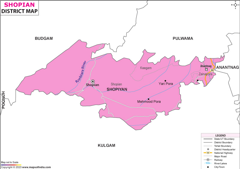
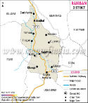
Tucked into the folds of the southern Kashmir Valley, Shopian earns its nickname, Kashmir's "Apple Bowl," through its lush orchards and fertile slopes. Sitting high - around 2,146 meters - it rests roughly fifty-one kilometers from Srinagar, where government offices shift each summer. North brings you to Pulwama; turn east, and Kulgam appears on the map. To the far side, beyond the rugged peaks of the Pir Panjal range, lie Rajouri and Poonch. Once part of an ancient path carved by Mughal travelers, this stretch now hums quietly with movement - not just goods passing through, but echoes of older journeys too. Home to royal travelers centuries ago, the name “Shopian” likely stems from “Shah-payan,” hinting at its past as a stopover for Mughal rulers moving between Delhi and Srinagar. Instead of modern labels, villagers often say “Sheen-e-van,” a phrase pointing to snowy woods blanketing the hills.
History & Culture
Hidden among mountain curves, Shopian shifted with every turn of power across northern lands and beyond. Following ancient routes through steep ridges, the town rose along a road once paved by empire. When rulers like Akbar moved southward with vast processions, dust marked their passage. Stone patterns changed after each visit. Even today, walls whisper traces left behind by distant thrones.
Long before recent times, Shopian held importance in administration. From 1872 to 1892, it functioned as one of six key Wazarats across Kashmir, handling broad trade routes over mountains along with regional oversight. After India's division, it remained a notable tehsil within Pulwama district. By March 2007, the Jammu and Kashmir government elevated its standing, naming it a separate district - aimed at improving local rule and growth efforts. That shift did not emerge suddenly but built on older layers of influence.
Among rural communities here, age-old farming rhythms shape daily life alongside quiet devotion. Known across generations, this area marks where Mir Sayyid Ali Hamadani first stepped into Kashmir - recorded widely as a key passage point during his journey to share Islamic thought. Reverence for that moment remains strong, woven into local memory through stories passed down by elders. Spiritual roots run deep, shaped not by grand gestures but by a steady presence over centuries.
Out in Shopian, rhythms of daily culture follow the turning year. Autumn, known as Harud, pulses at the center - when households shift toward orchards, gathering fruit in unison, sorting it, sealing crates. While Apple works unfold, so do old songs and stories pass between generations. Meals come alive through group effort, especially wazwan feasts that mark joyous moments. Even faith events shape common life: Eid, Milad-un-Nabi, and Sufi gatherings pull crowds into peaceful unity, moment by moment.
Economy
Farming shapes most of Shopian’s livelihoods, with horticulture forming the core activity. Known widely for high-quality apples, the region stands out within Jammu and Kashmir's fruit production landscape. Instead of mere local sale, these apples reach markets throughout India, also finding demand beyond national borders. Because of this role, Shopian carries a reputation often linked to apple abundance - called by many the "Apple Bowl of Kashmir." Yet it is the consistency of harvests that sustains such recognition.
Public sector jobs exist within administrative departments, educational centers, medical services, and community councils. Support for growing crops arrives via financial aid, refrigerated warehouses, and collective groups.
Slow growth marks retail, transportation, transport-linked work, and travel-based efforts. Improved access emerged after the building of the Mughal Road, followed by a rise in the movement of goods, and visitors increased too.
Pears, cherries, along with walnuts and almonds, grow here besides apples. Economic variety comes partly from raising livestock, partly from cottage crafts. Yet weather shifts combined with unrest threaten local stability. Growth that lasts depends on broadening sectors while updating methods.
Tourism
Hidden among orchards and gentle hills, Shopian unfolds slowly, revealing more than it first shows. Old stone buildings speak without words, marking years gone by. Where people once prayed, belief meets memory, creating spaces meant for stillness. Instead of grand displays, the land draws attention through small details - each corner shaped by many hands across time. Snow covers everything in winter; spring brings color; summer fills valleys with growth. Through these changes, one thing stays: a place rooted deeply, yet open to whoever walks quietly through. Deep within the valley, the Veshu River tightens into a narrow channel ahead of its drop into a steep ravine, where thunderous water echoes among tall pines reaching up to icy summits. Not particularly high, yet powerful in presence, the fall draws eyes by strength alone. People stay longer on footpaths here, often stopping near damp stones covered in green growth - some freezing moments through camera views - not hurrying past but matching their pace to the place itself.
Over the tree line sits Peer Ki Gali, a narrow path on the old Mughal Road shaped by constant wind. Beyond its edge, sightlines run without break toward the sharp ridges of the Pir Panjal range. Old tales tell of saints moving through these heights, their presence lingering in local memory. Though used to connect Kashmir and Poonch, the trail serves less as a road than a boundary - defined by elevation, quiet, and echoes of devotion.
High up between rolling hills, this wild stretch covers 341 square kilometers of shifting landscapes. Home to the shy Markhor goat, the rarely seen Himalayan black bear, and slender musk deer that move like shadows through brush. Voices of birds rise often, weaving texture into silence. Those who study life outdoors come here - not to lead, but to listen - where earth has voice, people step lightly.
Far beyond busy roads, Sedow and Keller cradle woodlands that lean toward murmuring creeks, then give way to open fields. Here, time listens more to the weather than clocks. Old ways move gently from one family to the next, untouched by show or performance. Visitors come not chasing newness, yet leave with sharper sight, drawn instead to paths under leafy cover, homes built from timber, and routines shaped by light and soil. In such places, journeying shifts - less about doing, more about seeing what already is.
Winding through mountain saddles, this path once bore imperial footsteps, now replaced by quiet exploration. Among rocky outcrops, clusters of pine break the slope's rhythm with pockets of calm. Traversed by traders long ago, the road now frames slow observation alongside forward motion. Scenic drops unfold without warning - valleys below, ridges above - all threaded by a ribbon of worn asphalt.
Among them, these places define Shopian - a region where highland paths meet sacred spots, cascading falls, and open fields. Stone routes carry echoes of earlier times, while fruit groves and hamlets mark life today; what comes next depends on how carefully heritage blends with exploration. Visitors encounter depth instead of definitions, every trail revealing both memory and surprise, weather shifting the scenery though never touching the core nature of the place.
Demographics
Among the figures recorded in 2011, Shopian reported nearly 266,000 residents; most lived outside urban zones - close to 95 percent, in fact. Education levels stood at a measured 62.49 percent enrollment, below countrywide numbers yet signaling slow forward movement. Progress in learning access emerges via public classrooms, independently run centers, and locally driven programs.
Most people speak Kashmiri first - it dominates daily communication, covering nearly 88 percent of residents. Because remote grazing lands support varied ethnic groups, Gojri emerges next, carried mainly by Gujjar and Bakerwal herders, holding close to a 9 percent share. Following that, Pahari appears in around 1.8 percent of homes. In government settings, Urdu shares space with English, both operating formally across institutions.
Administration
Among its divisions, Shopian district holds nine tehsils - Keller, Zainapora, Barbugh, Hermain, Keegam, Chitragam, Kanipora, Ramnagri, and Shopian itself. Spread across the region are 231 populated villages, alongside a single municipal committee managing thirteen wards. Community development blocks exist here, too, forming part of the structure. Governance, learning, and commerce center on Shopian town, where administration finds its base.
A single Deputy Commissioner leads the district administration, with assistance provided through officials managing sectors such as education, along with health services, farming initiatives, and village-level progress. At local levels, self-governance structures function actively so that residents contribute directly when choices are made.
Among the ways progress takes root here, oversight flows through community development blocks, shaping local efforts. Within the structure of rural administration, the area includes precisely 231 populated villages grouped into several Patwar Halqas. Oversight of basic city services in the main township rests with the Shopian Municipal Committee - this body works across 13 elected wards, carrying out essential functions.
| Official Name | Shopiyan |
| Location | Jammu and Kashmir |
| Area | 612.87 sq. km |
| Population | 2.68 lacs |
| Language | Kashmiri, Urdu, Hindi |
FAQs
Q1: How many gram panchayats are there in the Shopiyan district?
There are 98 gram panchayats in the district .
Q2: What is the population of the district?
The population of the district, according to the 2011 census, is 2.68 lacs.
Q3: What is the district famous for?
Among Himalayan slopes, Shopian earns global recognition - its orchards yield India’s most prized apples. High above, Peer Ki Gali reveals a silent mountain gateway blanketed in mist. Not far, Aharbal Waterfall thunders down with raw, unshaped force. Life in these valleys pulses gently, rooted deep in soil, season, and harvest.
Last Updated on : August 21, 2026
