
Pune gained international popularity for being the location of the Osho International Meditation Resort. A fusion of spirituality, capitalism and history, it is a thriving metropolis of modern India. The city is also a flourishing centre for business and academia.
The magnificent forts and other historical monuments are reminders of its glorious past. Home to many colleges and universities, it is a prime location for manufacturing and IT sectors. Pune has emerged as a new start-up hub in recent years.
Places to Visit in Pune
Featuring Mughal and colonial-era styles, the city is known for unique architecture. From temples to museums, the city has a lot to offer to travellers and saints alike. The "Garden City" movement layout, which was developed in the early 20th century, helped revitalize the architecture.
The Parvati Temple, Dagadusheth Halwai Ganapati Temple, Chaturshringi Temple, Chand Tara Masjid, and Ohel David Synagogue are some the most popular religious sites in Pune.
History buffs would love to check out the Aga Khan Palace, Shaniwarwada, Pataleshwar Cave Temple, Mahatma Phule Museum, Raja Dinkar Kelkar Museum and Pune Tribal Museum. The Rajiv Gandhi Zoological Park and Pu La Deshpande Udyan are popular among city residents of all age groups.
Places to Visit near Pune
What is even better when you plan your trip to this beautiful city is that you will not only be able witness the spectacular tourists destinations in Pune, but places near it as well. Most of the following tourist places near Pune can be reached with just a four to five hours drive.
- Lonavala
- Lavasa
- Alibaug
- Raigad
- Malshej Ghat
- Mumbai
- Rajmachi
- Trimbakeshwar, and many more.
Hotels in Pune
- JW Marriott Hotel Pune
- The Gateway Hotel Hinjawadi Pune
- Vivanta By Taj - Blue Diamond, Pune
- Hyatt Regency Pune
- Hotel Ibis Pune
- Four Points by Sheraton Hotel & Serviced
Educational Institutions in Pune
- Symbiosis International University
- Fergusson College
- MIT Institute Of Design
- Film and Television Institute of India
- Army Institute of Technology, Pune
- Indian Institute of Science Education and Research
Pune City Information | |
|---|---|
| Country | India |
| State | Maharashtra |
| District | Pune |
| Area | 479 km2 (185sq mi) |
| Population | 3n124,458 as per Census 2011 |
| Population Density | 6,500/km sq (17,000/sq mi) as Census 2011 |
| Languages | Marathi, Hindi, Gujarati and English |
| Official Language | Marathi |
| Literacy Rate | 86.15% as per Census 2011 |
| Sex Ratio | 915/1000 |
| Time zone | IST (UTC+5:30) |
| Pin code | 411001 |
| Area code | 20 |
| Lat Long | 18.5203° N, 73.8567° E |
| Religion | Hinduism, Islam, Buddhism, Jainism and Christianity |
| Festivals | Ganesh Festival, Pune Festival, Shivaji Maharaj Jayanti and Bhaubeej |
| Education | Indian Institute of Science Education and Research (IISER), University of Pune and Film and Television Institute |
| Sister Cities | Fairbanks, San Jose (United States), Bremen (Germany), Troms (Norway) and Vacoas-Phoenix (Mauritius) |
| Sports | Athletics, Cricket, Basketball, Badminton, Field Hockey, Football, Tennis, Kabaddi, Paragliding, Kho-kho, Rowing and Chess, Pune International Marathon and Pune Football Club |
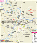
| Airport | Pune International Airport |
| Railway Station | PUNE/Pune Junction (6 PFs) Railway Station |
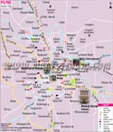
| Tourist Attractions | Shaniwar Wada, Dagadusheth Halwai Ganapati Temple, Raja Dinkar Kelkar Museum, Saras Baug, Parvati Hill, Osho Ashram, Vishrambaug Wada and Bund Garden |
| Nearby Tourist Attractions | Mahabaleshwar, Diveagar, Matheran, Kashid Beach, Lonavala, Alibaug and Panchgani |
| Notable People | Mahatma Jyotiba Phule, Shantanurao Laxmanrao Kirloskar, Bal Gangadhar Tilak, Dhanraj Pillay, Prabha Atre and Raghunath Mashelkar |
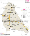
| National Highway | NH-4,9,50 |
MOI.AB.28.01.17
Last Updated on : May 12, 2026
More About Pune
Places to Visit in Pune
| Find Distance from Pune to other Indian Cities | |||