Andhra Pradesh, one of India's largest states is spread over 2, 75,069 square kilometers and located between latitude 12° N and 22° N, and between longitude 77° E and 84° E.
The state touches boundaries with Chhattisgarh and Odisha in the north, and Tamil Nadu in the south. In the east, the state, with a coastline of 974 kilometers, is bounded by the Bay of Bengal , and in the west it forms a border with Maharashtra.
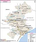
Andhra Pradesh is divided into 23 districts, each with a district headquarter. These districts fall into three distinct cultural and geographical regions in Andhra Pradesh- Telangana, Rayalaseema, and the coastal areas. The river Krishna divides Telangana and Rayalseema regions. Both these regions are part of the Deccan plateau. The coastal areas are part of the Eastern Ghats and are plains.
The capital of the state is at Hyderabad. Some of the district headquarters are Adilabad, Kakinada, Kurnool and Anantapur.
Districts of Andhra Pradesh |
 |
 |
 |  |
| Anantpur District Map | Chittoor District Map | YSR District Map | Nellore District Map |
 |
 |
 |
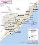 |
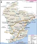
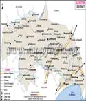
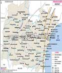
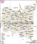
| East Godavari District Map | Guntur District Map | Prakasam District Map | Srikakulam District Map |
 |
 |
 |
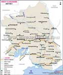 |
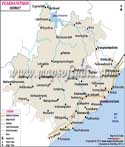
| Krishna District Map | Kurnool District Map | Vishakhapatnam District Map | West Godavari District Map |
 |
|||
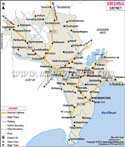
| Vizianagaram District Map |
North Districts
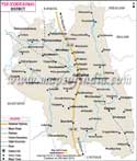
The Telangana region has 10 districts, which are: Hyderabad, Khammam, Adilabad, Mahbubnagar, Karimnagar, Nalgonda, Medak, Rangareddy, Warangal, and Nizamabad. Nalgonda district has the largest area in the state and Khammam district has a sizable tribal population. Karimnagar is an agriculture center, while Hyderabad district which has the state capital is one of the urban centers. The rural areas around Hyderabad are included in Ranga Reddy district.
South Districts
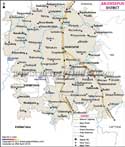
Four districts in the south of the state are considered part of the Rayalseema region. These are Kurnool, Anantapur, YSR, and Chittoor. YSR district has scarce rainfall and is drought prone. Chittoor district has hilly areas.
Coastal Districts
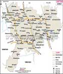
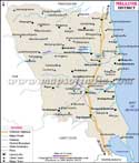
The nine districts of Vizianagaram, Srikakulam, East Godavari, West Godavari, Vishakhapatnam, Guntur, Krishna, Nellore, and Prakasam are coastal areas. The port city Vishakhapatnam is the second largest city in the state and also the headquarters of Vishakhapatnam district. Krishna district, one of the best connected districts has one of the busiest rail junctions of the country at Vijaywada. Guntur district, with a population of 4,889,230 is the most populous in the state.
List of Districts in Andhra Pradesh
| Sr. No. | District | District HQ | Population (2011) | Growth | Sex Ratio | Literacy | Area (km2) | Density (/km2) |
|---|---|---|---|---|---|---|---|---|
| 1 | Anantapur | Anantapur | 4081148 | 12.10% | 977 | 63.57 | 19130 | 213 |
| 2 | Chittoor | Chittoor | 4174064 | 11.43% | 997 | 71.53 | 15152 | 275 |
| 3 | East Godavari | Kakinada | 5154296 | 5.16% | 1006 | 70.99 | 10807 | 477 |
| 4 | Guntur | Guntur | 4887813 | 9.47% | 1003 | 67.4 | 11391 | 429 |
| 5 | Krishna | Machilipatnam | 4517398 | 7.87% | 992 | 73.74 | 8727 | 519 |
| 6 | Kurnool | Kurnool | 4053463 | 14.85% | 988 | 59.97 | 17658 | 229 |
| 7 | Prakasam | Ongole | 3397448 | 11.05% | 981 | 63.08 | 17626 | 192 |
| 8 | Sri Potti Sriramulu (Nellore) | Nellore | 2963557 | 11.05% | 985 | 68.9 | 13076 | 227 |
| 9 | Srikakulam | Srikakulam | 2703114 | 6.52% | 1015 | 61.74 | 5837 | 462 |
| 10 | Visakhapatnam | Visakhapatnam | 4290589 | 11.96% | 1006 | 66.91 | 11161 | 384 |
| 11 | Vizianagaram | Vizianagaram | 2344474 | 4.23% | 1019 | 58.89 | 6539 | 358 |
| 12 | West Godavari | Eluru | 3936966 | 3.51% | 1004 | 74.63 | 7742 | 508 |
| 13 | YSR | Kadapa | 2882469 | 10.79% | 985 | 67.3 | 15359 | 188 |
Last Updated on : May 11, 2026