

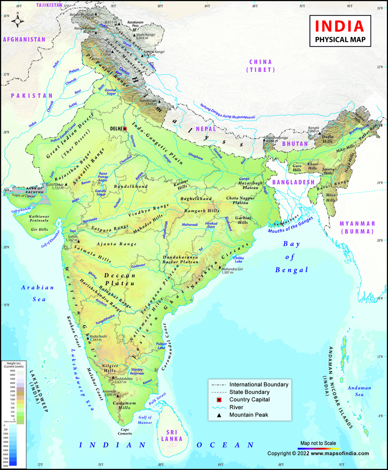



Physical Map of India With States and Major Features
A Physical Map of India is a map that displays the natural features and topography of the country. It represents mountains, rivers, plateaus, plains, coastal regions, and islands, which are a part of the physical geography of India. A physical map is used to show elevation, terrain and the distribution of various landforms, while a political map shows mainly state boundaries.
India's topography is a diverse one, stretching from the snow-clad Himalayas in the north to the tropical islands in the south. India's physical map provides a clear representation of these natural regions and helps identify the location of different landforms across the country. The country's geography encompasses some of the highest mountains in the world, fertile river plains, ancient plateaus, desert areas and extensive coastal regions. These are the factors that affect the Indian climate, agriculture, economy, biodiversity and settlement patterns.
A physical map of India with states shows readers what part of the country it occupies and the distribution of natural features in various regions of India. The indian physical map is widely used by students, researchers and geography enthusiasts to study the physical features of India in detail. It gives a perspective on mountains, rivers, plateaus and other significant landforms and their relation to states.
Major Physical Features of India
Mountain Ranges
One of the most significant geographical features depicted on the physical map of India is the mountain ranges. The Himalayan Mountain Range is the northern border of India and is home to some of the world's tallest peaks. They affect the Indian climate, are the seats of glaciers and give water to the great rivers. The physical features of India map highlights the relationship between these mountain ranges and other geographical regions of the country.
In addition to the Himalayas, India also has the Western Ghats and the Eastern Ghats in the southern peninsula. They shape rainfall patterns, host forests and are inhabited by various wildlife.
Plateaus
Plateaus are areas of high ground that have relatively level terrain. The peninsular Plateau of India is one of the oldest landforms, and its total area is quite large, which includes the central and southern parts of India. A physical map of India also helps in identifying plateau regions and understanding their role in India's natural resources and economic activities.
The Deccan Plateau and Central Highlands are significant plateau areas, which have mineral resources, agriculture and unique landscapes. Coal and natural resources of iron ore and manganese are abundant in these areas.
Plains
The deposition of sediments carried by the major rivers of India has created the Northern Plains of India. These plains are one of the most productive areas in the world and are used for large-scale agriculture.
The Indus, Ganga and Brahmaputra river systems have formed large plains which are home to millions of Indians and play an important role in agricultural production in India.
Deserts
The Great Indian Desert, or Thar Desert, is spread mainly in the state of Rajasthan and also in parts of Gujarat, Haryana and Punjab. The sandy deserts are characterized by sand dunes, high temperatures, low precipitation and other factors. It is home to a unique flora and fauna and traditional communities in the face of a very challenging climate.
Coastal Regions
India is surrounded by the Arabian Sea and the Bay of Bengal with a total coastline of over 7,500 km. The coastal area is split into a western and eastern coastal plain.
The western coastal plains are narrow and are made up of the Konkan and Malabar coastal regions. The eastern coastal plains are broad, with the major river deltas created by the Ganga, Godavari, Krishna and Mahanadi rivers.
Islands
The two important island groups on the physical map of India are:
The Andaman and Nicobar Islands are in the Bay of Bengal with tropical forests, coral reefs and marine biodiversity.
The Lakshadweep Islands are in the Arabian Sea and are known for their stunning coastal habitats, coral reefs and lagoons.
Physical Features of India Explained
Himalayan Mountain Range
Location
The Himalayan Mountain Range is located in the northern part of India and extends from Jammu and Kashmir to Arunachal Pradesh. It is a natural border between the Indian subcontinent and the Tibetan Plateau.
The Himalayas can be divided into three parts – the Greater Himalayas, the Lesser Himalayas and the Shiwalik Range. Glaciers and the highest peaks are found in the Greater Himalayas, and valleys, forests and hill regions are found in the Lesser Himalayas. The outermost Himalayan range is called the Shiwalik range, which is composed of younger rocks.
Major Peaks
There are a number of significant mountain peaks in the Himalayan region. Kanchenjunga is one of the highest peaks in the world and is located in the Himalayan region of India. Another important peak, which is also tall and geographically important, is Nanda Devi.
Importance
The Himalayas are an important part of Indian geography. They shield the country from very cold winds coming from Central Asia and affect the Indian monsoon system. The rivers of the Himalayas receive water from glaciers. The glaciers supply water to some important rivers like the Ganga, the Yamuna and the Brahmaputra.
It is also a habitat for forests, animals, tourism and the generation of hydroelectric power. Himalayan ecosystem is significant to ensure environmental balance.
Northern Plains of India
Northern Plains are one of the significant physical regions marked on the physical map of India. The India map physical view of these plains helps explain the connection between rivers, fertile soil and human settlements. These were deposited by sediments brought by rivers over thousands of years.
Indus-Ganga-Brahmaputra Plains
There are three main river-based regions that make up the Northern Plains. The Indus Plain occupies the north-west of the subcontinent, and the Ganga Plain is spread out in northern and eastern India. It is the Brahmaputra Plain, mainly in Assam, which is rich in biodiversity and fertile land.
The plains are flat and are rich in alluvial soil, which is good for agriculture and human habitation.
Agriculture Importance
The Northern Plains are regarded as the "agricultural hub" of India. Major crops like wheat, rice, sugarcane and pulses are grown on the fertile soil and with the presence of river water.
The area also provides a lot of people with a good living by allowing them to farm, transport goods and settle in the area.
Peninsular Plateau
The peninsular plateau is an ancient geological area that makes up the central and southern part of India. It is made up of hard crystalline rocks and has a stable land structure. On the India physical map, the geographical position of the Deccan Plateau and Central Highlands can be easily understood.
Deccan Plateau
A plateau is situated between the Western Ghats and Eastern Ghats, which is known as the Deccan Plateau. It spans over Maharashtra, Karnataka, Telangana, Andhra Pradesh and Tamil Nadu.
The soil of this plateau is black and is suitable for growing cotton. It is also endowed with minerals and has some significant rivers like Godavari, Krishna and Kaveri.
Central Highlands
The Central Highlands are north of the river Narmada and consist of parts of the states of Madhya Pradesh and Rajasthan. The prominent features of this region are the Vindhya and Satpura ranges.
The area is characterized by forests, mineral resources, agriculture and varied landscapes.
Indian Desert Region
Thar Desert Location
The Thar Desert covers the major part of the state of Rajasthan and a small part of Gujarat, Punjab and Haryana. It is also referred to as the ‘Great Indian Desert', which is a major geographical region of West India.
The image shows a desert landscape with some vegetation and dunes. It's an area that has adopted unique cultural traditions and wildlife.
Climate
Thar Desert experienced extreme aridity as far as climate and precipitation were concerned. The climate of the Thar Desert was very dry, and there was very little rainfall there and very high temperatures. Warm sunny summers and possibly cold nights in winter, especially if it snows. The weather affects the plants, animals and the lives of the people who live in this area.
Coastal Plains and Islands
Eastern and Western Coastal Regions
The coastal plains of India are divided into the western coastal region and the eastern coastal region according to the position of the coastal plains with respect to the seas. The physical features of India map clearly represent these coastal divisions along with islands and surrounding water bodies.
Western Coastal Plains are situated along the Arabian Sea and comprise the Konkan Coast, Karnataka Coast and Malabar Coast. The value of these areas is in their ports and their importance in supporting fishing, trade and tourism activities.
The Eastern Coastal Plains are along the Bay of Bengal and are broader. Major river deltas formed by the Ganga, Godavari, Krishna and Mahanadi are present in them. These areas are important for agriculture and coastal activities.
Andaman & Nicobar Islands
Andaman and Nicobar Islands are in the Bay of Bengal. They are famous for their tropical forests and coral reefs, marine biodiversity and special ecosystems.
These islands are also strategically important because of their location near important maritime routes.
Lakshadweep Islands
The territory of Lakshadweep consists of a group of Coral Islands in the Arabian Sea. The islands are famous for their beaches, marine biodiversity, coral reefs and lagoons.
The area is also a popular tourist destination and home to a number of fishing villages.
Importance of India’s Physical Map
A physical map of India helps students understand the major physical features of India and how they relate to human activities. The climate of the mountains affects the other types of landforms, as the plains are also suitable for farming; the plateaus provide minerals; the deserts have a unique ecology, and coastal areas are important areas of trade and tourism. A detailed indian physical map improves geographical understanding by showing how different physical features influence climate, resources and settlements.
Students, research personnel, travellers and geographers would find the physical geographical map of India helpful. It gives students a comprehensive knowledge of the contribution of the various types of landforms to India's natural beauty, its resources and development.
FAQs
Q1: What is a physical map of India?
A physical map of India shows natural features like mountains, rivers, plains, plateaus and deserts.
Q2: What features are shown on India physical map?
It shows mountains, rivers, plateaus, plains, deserts, coastal areas and islands.
Q3: How is a physical map different from a political map?
A physical map shows landforms, while a political map shows state and country boundaries.
Q4: Which mountain ranges are shown on the physical map of India?
The Himalayas, Western Ghats and Eastern Ghats are shown on the map.
Q5: Why is a physical map useful for students?
It helps students understand India's geography and natural features.
Q6: What are the major physical divisions of India?
The major divisions are the Himalayas, the Northern Plains, the Plateau, the Desert, the Coastal Plains and the Islands.
Q7: How does a physical map help in understanding India’s geography?
It shows the location and distribution of different natural features.
Last Updated on: July 23, 2026
| Union Territories of India |
|---|
India general Maps