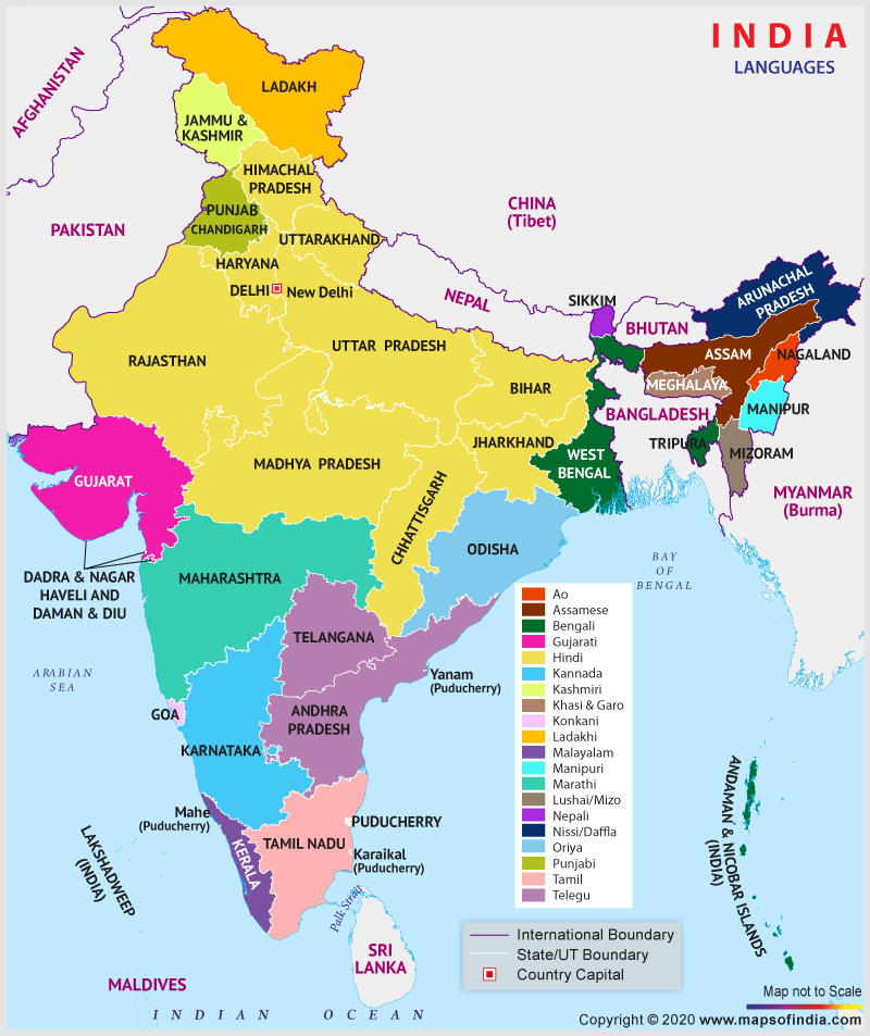
Language is an important part of communication between humans. It helps individuals to communicate easily and share their thoughts, feelings and ideas through spoken words. Every community, be it a small group living together, a country or people living in the same geographical area has its language.
India, a geographically and culturally diverse country witnesses varied languages that are spoken in different parts of the nation. As mentioned in the eighth schedule of the constitution of India, there are 22 constitutional languages, namely; Assamese, Bengali, Gujarati, Hindi, Kannada, Kashmiri, Konkani, Malayalam, Manipuri, Marathi, Nepali, Oriya, Punjabi, Sanskrit, Sindhi, Tamil, Telugu, Urdu, Bodo, Santhali, Maithili, and Dogri.
Some of these languages have different variants based on the demographics of an area. Moreover, there are a wide variety of local and tribal languages that are spread across the nation but are not mentioned in the constitution.
Unlike other nations, India does not give the status of ‘national language’ to any language. Instead, Article 343 (1) of the Indian constitution made the “Hindi” language in the Devanagari script the official language of the country that should be used for all official purposes. Along with that, the “English” language was given the status of associate official language.
Both Hindi and English are spoken widely in the whole of India. Besides all the 28 states and eight union territories of India also have other languages that are spoken within their boundaries.
Here is a list of languages spoken in different states and union territories of India:
| Name of State/Union Territory | Major Language Spoken | Other Languages Spoken |
| Jammu and Kashmir | Kashmiri | Dogri and Hindi |
| Ladakh | Ladakhi | Tibetan, Urdu and Balti |
| Himachal Pradesh | Hindi | Punjabi and Nepali |
| Punjab | Punjabi | Hindi |
| Uttrakhand | Hindi | Urdu, Punjabi and Nepali |
| Haryana | Hindi | Punjabi and Urdu |
| Delhi | Hindi | Punjabi, Urdu and Bengali |
| Uttar Pradesh | Hindi | Urdu |
| Rajasthan | Hindi | Punjabi and Urdu |
| Madhya Pradesh | Hindi | Marathi and Urdu |
| Chhattisgarh | Hindi | Bengali and Oriya |
| Bihar | Hindi | Maithili and Urdu |
| Jharkhand | Hindi | Santali, Bengali and Urdu |
| West Bengal | Bengali | Hindi, Santali, Urdu, Nepali |
| Sikkim | Nepali | Hindi, Bengali |
| Assam | Assamese | Bengali, Hindi, Bodo and Nepali |
| Arunachal Pradesh | Bengali | Nepali, Hindi and Assamese |
| Nagaland | Bengali | Hindi and Nepali |
| Mizoram | Bengali | Hindi and Nepali |
| Tripura | Bengali | Hindi |
| Meghalaya | Bengali | Hindi and Nepali |
| Manipur | Manipuri | Nepali, Hindi and Bengali |
| Orissa | Oriya | Hindi, Telegu and Santali |
| Maharashtra | Marathi | Hindi, Urdu and Gujarati |
| Gujarat | Gujarati | Hindi, Sindhi, Marathi and Urdu |
| Dadra Nagar Haveli and Daman Diu | Gujarati | Hindi and Konkani |
| Goa | Konkani | Marathi, Hindi and Kannada |
| Karnataka | Kannada | Urdu, Telugu, Marathi and Tamil |
| Andhra Pradesh | Telugu | Urdu, Hindi and Tamil |
| Kerala | Malayalam | None |
| Lakshadweep Islands | Malayalam | None |
| Tamil Nadu | Tamil | Telugu, Kannada and Urdu |
| Puducherry | Tamil | Telugu, Kannada and Urdu |
| Andaman and Nicobar Islands | Bengali | Hindi, Tamil, Telugu and Malayalam |
Last Updated on : January 14, 2026
- National Science Museums in India
- Jyotirlinga Shrines
- Geological Map of India
- Canals in India
- Major Lakes in India
- Heritage Map of India
- Pin Code Zones in India
- Per Capita Income of India
- Major Sea Ports
- Languages in India
- Climate map of India
- Parlimentary Constituencies in India
- Tourist Circuits in India
- Metallic Minerals in India
- Cold Desert Map
- Major Electricity Generator Plants
- Religions In India
- Major Earthquakes in India
- Major Hydro Power Plants
- Indian States and Union Territories
- Cabinet Ministers
- Map of Indian States and Union Territories Enlarged View
- Physiographic Map of India
- Religious Places in India
- Geographical Map of India
- Dams in India
- India Coal Reserves Map
- India Political Map Enlarged View
- India Satellite Map
- Topographic Map of India
- Population Map Of India
- Natural Hazard Map of India
- Tourist Map of India Enlarged View
- Tier I and Tier II Cities of India
- Cyclone Prone Areas in India
- Outline Map of India Enlarged View
- Wine Producing Regions in India
- Map of Major Airports in India
- Birth Rate in India
- Statehood Movements in India
