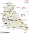
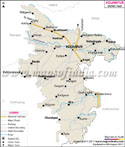
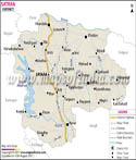
The district of Gadchiroli is situated in the state of Maharashtra in western India. The administrative headquarters of the district is the town of Gadchiroli. The district was formed on 26th August 1982 by dividing Chandrapur district. Gadchiroli District Map will be very helpful for those planning a trip to Gadchiroli.
The district is situated in the north eastern part of the state. It is bordered by the states of Chhattisgarh and Andhra Pradesh. The district is 80 kilometers from Chandrapur while Nagpur is 180 kilometers from here.
The district's population is around 9, 70,294 according to the 2001 Census of India. The population of males is around 4, 91,101 while that of females is approximately 4, 79,193.
The district is covered with hills and forests and is considered as a tribal area. It is well-known for its Tendu leaves and bamboo. The main agriculture produce of the district is paddy. Other agricultural products include linseed, wheat, jowar and tur. The taluka of Armori is home to the Tussar Silk Worm Centre.