






About
Some districts are very easy to see, and then there is Ratnagiri. This district forms the background of a dramatic plot on the Konkan coast of Maharashtra and is a kind of epic through which murmurs of the Arabian Sea against the rocky coast and transitions of time, as seen in the emerald hills, resound. It can be easily observed that the name Ratnagiri is derived from the Sanskrit root words of ‘Ratna’, which means ‘jewel’ and ‘Giri’, which means ‘hill’. The “Hill of Jewels”, in all its majestic beauty, historic forts and cultural wonders, is most appropriate when you visit this district.
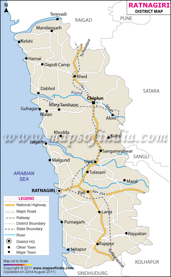
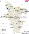
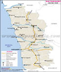
The district Ratnagiri is situated in the south-west part of Maharashtra with an area of 8208 sq.km. It is surrounded by the Arabian Sea on its west, and by the peak of Sahyadris on its East; thereby creating a strong geographical contrast for ages that had supported this very important identity of it. A quick look at the Ratnagiri district map will reveal that it is surrounded by the sea, has several rivers and has a hilly topography, which have all shaped settlements, trade routes and the culture of this district.
With geography being only one of its features, Ratnagiri still has much more to offer. Natural, historical and human influences and processes converge and interrelate. Each and every hill holds the key to a lost story. Each fort seems to protect from the past, that of naval wars. These are stories that haven't been written in these villages yet.
History & Culture
The history of Ratnagiri district is multi-layered, complex and interesting. This area was part of the ancient trading routes that connected the western part of India with far off countries over the sea from the Arabian Sea. Merchants, sailors and travellers came and went, bringing with them their goods and ideas; the Konkan coast was a place of trade and commerce.
The district was ruled by several dynasties such as Satavahanas, Chalukyas, Rashtrakutas, Shilaharas and Yadavas. Architecture, local legends and traditions are legacies of both these ruling powers. Today, one can see areas on the Ratnagiri district map which reflect these historical elements in the form of temples, settlements and archaeological ruins.
Interesting culture of Ratnagiri as well. The primary language is Marathi, but there are numerous coastal communities with a Konkani influence. The folk and devotional music along with the Dashavatara performance, is still in the people's cultural life.
Colours are used throughout the whole district and are displayed to celebrate festivals. Ganesh Chaturthi has a special significance in the local society. The houses are decorated and prayers are recited, music plays and there are communal celebrations. Temple festivals, along with Holi, Diwali and Gudi Padwa, are celebrated along with great enthusiasm.
Food is another way of self-identification. The coconut, rice, seafood, kokum and mangoes are the basis of several local dishes. The Ratnagiri district is also a famous mango-producing district of India, with a wide discussion on agriculture.
The district's cultural heritage is also a reflection of education and social reform. Ratnagiri has produced a number of eminent personalities, freedom fighters, scholars, and social reformers who have made their impact not only in Maharashtra but also beyond.
Economy
The economy of the district Ratnagiri is a blended economy with traditional occupations along with emerging sectors, which provides an economic base for both the rural and urban population.
Agriculture is still one of the most significant economic activities. Rice, cashew nut, coconut, arecanut and mango are grown in the fertile soil, sufficient rainfall and favourable climatic conditions. Out of these, the Alphonso mango is the most famous product of this district and it has become a source of earning for the farmers and exporters in the district.
Fishing is also an important economic activity. The Arabian Sea offers abundant marine wealth, and there are many fishing communities that rely on deep sea and coastal fishing. The fish processing and seafood exports industry is a significant source of revenue for the district.
In the Government Sector, jobs are created in district administration, education, healthcare, public works, agriculture departments and police. Government institutions are important in providing public services and helping to promote rural development.
The contribution from the Public Sector comes in terms of infrastructure projects, transport systems, power distribution and port functions. Growth of industries has been gradual, with attempts to improve connectivity and investment. The strategic position of the port and feeder roads is also indicated in the Ratnagiri district map, which plays an important role in the transport of goods and the integration with the country.
The services sector has become a big employer segment. The development of banking, education, healthcare, hospitality, retail trade, tourism services, and information technology-related activities is all areas that have grown in recent decades. In particular, tourism has created jobs for guides, transport operators, hotel workers, restaurant owners and local craftsmen.
Industrial activities consist of food processing, agro based industries, seafood processing, chemical industries and small scale engineering units. Ports and transportation facilities are located here to facilitate trade and commerce in the area.
Migration also has an impact on the economy of the district. There are a lot of people who migrate to Mumbai, Pune, and other large urban centres but have tight economic and social relations with their villages of origin. The remittances of these migrants are crucial for household income and development. Geography continues to influence economic opportunities in the Ratnagiri district, as shown in the Ratnagiri district map.
Tourism
Tourism in Ratnagiri district unfolds like an engaging adventure. Every one of these locations is filled with a fresh place, an ambience, and a twist.
The other popular tourist town of the district is Ganpatipule. It is known for its beautiful beach, ‘Ganpati' temple of the local deity and it is a must-see area for visitors during the pilgrimage. It is appealing and has spiritual value.
Ratnadurg Fort rises dramatically above the Arabian Sea. Visiting will be a memorable experience thanks to the massive walls, sweeping views and centuries of history. One of the remarkable landmarks of Ratnagiri, it has been prominently referred to in the history of Ratnagiri.
The Thibaw Palace is representative of a very fascinating period of the exiled Burmese kings. It sparks a lot of interest due to its architecture and because the colonial times have a certain level of significance. The strategicity of Jaigad Fort makes it stand out among all the other forts. It provides a panoramic view from the Fort and highlights the meaning of the Konkan area in the marine-environment.
Located in the middle of hills and waterfalls, Marleshwar Temple adds to the spiritual and natural beauty. This trip itself is a draw, as one passes through thick woods and twisty mountain highways.
On the coast, Velneshwar is a quieter and more beautiful beach. The golden sands, calm environment and tranquil surroundings bring an ideal atmosphere to relax. Swami Swaroopanand, the spiritual master, presides over Pawas and it is visited by the followers of the saint from all over Maharashtra. The other main aspect is a place of calm, adding to its spiritual character.
Aare-Ware beach is one of the most beautiful beaches in the State. The curves in the road are outwards looking, offering great viewpoint spots for much-loved photographers to shoot from. The Ratnagiri district map indicates that the district is endowed with plenty of beaches, forts, temples and natural beauty. The district will provide experiences which will remain long after historical or spiritual, adventurous or contemplative.
Demographics
The population of Ratnagiri district, as per the 2011 record, was approximately 1,615,069. The population density of the district is 197 persons per sq. km.
The district also reported a total literacy rate of 82.18%, which suggested that there was a positive focus on learning in the district. The literacy level among males was estimated at 90.93 per cent and among females at 74.53 per cent.
Marathi is the main language spoken in the district. Konkani is popularly used, particularly along the coast. Most educational institutions and urban centres can speak Hindi with ease and in English.
The district is also unique on the basis of a better sex ratio, as based on the 2011 census figures, there are more than 1122 females for every 1000 males in the district.
The map shows the Ratnagiri district with almost all the population residing in villages, which are distributed in the plains and along the river valley and up to the hilly region.
Administration
These Tehsils are administrative subdivisions used in the administration, development planning and delivery of public services within the District at the village level; there are nine Tehsils in Ratnagiri district – Ratnagiri Tehsil, Chiplun Tehsil, Khed Tehsil, Dapoli Tehsil, Guhagar Tehsil, Sangameshwar Tehsil, Rajapur Tehsil, Lanja and Mandangad Tehsil.
There are about 1537 villages and 16 towns in the district. There are settlements with dense populations at markets and small agricultural settlements within forests, rivers, and coastal regions.
The Ratnagiri district map is used in various administrative, infrastructure, agriculture, and disaster planning applications. The Ratnagiri district map is often used for administrative planning, infrastructure development, agricultural management, and disaster preparedness. This map remains useful for transport projects, tourism planning, protecting the environment and regional development projects, etc. The Ratnagiri district map continues to be a useful guide for settlement distribution.
Besides, the Ratnagiri district map helps in the management of coastal resources by the planners. The Ratnagiri map is consulted by researchers while studying the demographic trends. Tourists can access the Ratnagiri district map to guide them to the various attractions in a more efficient manner. The Ratnagiri district map is also used by government agencies during the process of development programmes. Geographical studies also use the map of the district of Ratnagiri in the educational institutions.
FAQs
Q1: How many villages are there in Ratnagiri district?
Ratnagiri district has approximately 1,537 villages according to the Census 2011 administrative data.
Q2: What is the population of Ratnagiri district?
The population of Ratnagiri district was 1,615,069 as recorded in the Census of India 2011.
Q3: What is Ratnagiri district famous for?
Ratnagiri district is famous for its Alphonso mangoes, beautiful Konkan coastline, historic forts, pristine beaches, maritime heritage, and significant cultural traditions.
Last Updated on : July 21, 2026
