
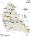
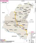
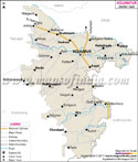

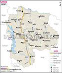
Thane district is the third largest industrialized place in Maharashtra. Thane district lies between North Latitude 18°42' to 20°20' and East Longitude 72°45' to 73°48'. The area covered by Thane is 9558 sq kms.
History of Thane
The name 'Thane' is derived from the ancient city 'Shristhanaka' which was ruled by the Shilahara kings. The British took over Thane district from the Peshwa in 1817 and it became part of north Konkan district.
In 1949, after India got independence the Jawhar state was merged with Thane district. Since, then Thane became separate taluka or district.
Thane climate
There are completely two different climates in district - one affects the western coastal plains and other on the eastern slopes of Sahyadri. The areas affected by the former are Thane, Vasai, Palghar, Dahanu which is humid and warm. On the contrary the latter areas, Kalyan, Bhiwandi, Vada, Ambarnath, Ulhasnagar and Talasari experiences less humidity.
inbow Lodging Hotel
- Ganeshpuri
- Bassein (Vasai)
- Masunda Talao
- Jawhar Palace
- Tansa wild life sanctuary
Last Updated on : May 12, 2026