Satara District Map


Click any neighbouring District/State on the Map and get the Detailed Map

District Map of Satara

separator Click here for Customized Maps arrow custom map
District Map of Satara Ratanagiri Raigad Pune Solapur Sangli Kolhapur
Print Email Save
*The Map showing National Highways, District headquarter, Major Roads, etc in Satara District, Maharashtra Disclaimer


  Major Districts of Maharashtra  
Pune District Map Aurangabad District Map Nagpur District Map Kolhapur District Map
Pune District MapAurangabad District MapNagpur District MapKolhapur District Map
    
Nashik District Map Satara  District Map Jalgaon District Map Ratnagiri District Map
Nashik District MapSatara District MapJalgaon District MapRatnagiri District Map
 
  other districts of Maharashtra >>

Satara District, an agricultural district, is known for its rich history, culture and picturesque landscapes. The district acquired its name from the seventeen towers, walls and gates that surround it.

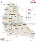
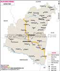
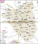
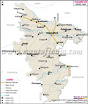
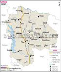
Location of Satara District:

The district of Satara is located in the western Indian state of Maharashtra. Spread across an area of almost 10484 square kilometers, the district is bordered by Solapur in the east, class="content-link">Ratnagiri in the west, Pune in the north and Sangli in the south. The Satara District Map clearly shows that the Rivers Krishna and Koyna flow through this place. Panchgani, Mahabaleshwar, Karad, Wai, Koregaon and, Koyananagar are the chief towns of Satara District.

arh Water Fall
  • Kas Lake
  • Popular excursion from Satara include Panchgani, Mayni and Anudh.

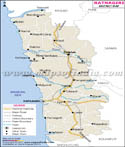
    Getting to Satara District:

    Satara District and its towns and talukas are well connected to one another as well with the rest of India by a good network of roads and rail. The Satara District Map points the major roads of the district. There are ample number of trains that come to Satara from different parts of the country on a regular basis. The nearest airport is the Mumbai Airport.


    Last Updated on : 25/04/2013