Raigad District Map


Click any neighbouring District/State on the Map and get the Detailed Map

District Map of Raigad

separator Click here for Customized Maps arrow custom map
District Map of Raigad Ratangiri Satara Pune Thane Mumbai Suburban Map
Print Email Save
*The Map showing National Highways, District headquarter, Major and other Roads, etc in Raigad District, Maharashtra Disclaimer


  Major Districts of Maharashtra  
Pune District Map Aurangabad District Map Nagpur District Map Kolhapur District Map
Pune District MapAurangabad District MapNagpur District MapKolhapur District Map
    
Nashik District Map Satara  District Map Jalgaon District Map Ratnagiri District Map
Nashik District MapSatara District MapJalgaon District MapRatnagiri District Map
 
  other districts of Maharashtra >>

Raigad is popularly known as, Raigarh district. It is located in Maharashtra state in Konkan region of India. The district got its name from Raigad fort which was formerly the ruled by Maratha leader Shivaji.

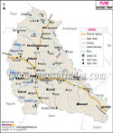
Enveloped by dense forests and Western Ghats of Sahyadri ranges; Raigad district is bounded by Mumbai Harbor, Thane, Pune, Ratnagiri districts. It is bounded by the Arabian Sea in the west.

Raigad district is very popular for its beaches, forts and other travel destinations. There are several tribes that inhabit in Raigad. Some of them are - Mahadev, Koli, Katkari and Thakur.
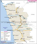
Transport in Raigad
The district is well connected with all the major highways. Sion-Panl highway, Mumbai-Pune expressway and NH17 are all linked. The Konkan railway is another option for transport to Raigad.

  • Raigad attractions
  • Raigad Fort
  • Murud Janjira Fort
  • Ballaleshwar Ganpati - Pali
  • Varad Vinayak Ganapati - Mahad
  • Birla Ganesh Temple
  • Kanakeshwar - Alibag
  • Elephanta Caves
  • Mandaw and Kihim Beach
  • Hari Harihareshwar Beach
  • Matheran

Last Updated on : 25/04/2013