

Aurangabad is a place of due importance since the ancient times because of it's the famous 'Silk Route'. The route traveled across the width of Asia to Europe. The city is named after the great Mughal Emperor Aurangzeb.
The beautiful city is enveloped by historical structures like, 'Ajanta & Ellora Caves' and the great 'Bibi Ka Maqbara'. The district Aurangabad falls under the Marathwada region and this is the reason it is also known as, 'City of Gates'. Know to be the fastest growing cities in the world; Aurangabad bestows all the important civic amenities.
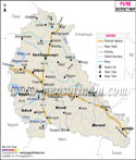
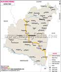
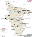
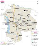
Geographical location of Aurangabad
Aurangabad is located in North 19deg; 53' 47" - East 75deg; 23' 54" on the World map. It features a semiarid climate.The annual temperature varies from 9deg; to 40deg; C. The maximum temperature ever recorded was 46deg; C and the minimum temperature was 2deg; C.
In the 1880s the city with cantonment has 59.1 per cent Hindus, 39.2 per cent Muslims, 1.1 per cent Christians, 0.1 per cent Parsis and others were 0.5 per cent with total population of 30,209. During that era, Brahmins were 7.1 per cent and Muslims were 38.5 per cent in the city area.
By 1971, the population grew to 1, 50, 514 (excluding the cantonment area) and the growth rate from 1961 to 1971 was 71.86 per cent. It was noteworthy that this was the highest growth in the state. It was higher than Greater Bombay which grew by on 43.75 per cent.
Marathi and Urdu are the primary languages of the city. As per 1961 census, Marathi speaking residents were 43.6 per cent, Hindi speaking were 11.99 per cent and Urdu speaking residents were 36.69 per cent.
Aurangabad Economy
Evidences are present which proves that Aurangabad was trading hub since four centuries. It is geographically located on the trade route which connects northern and Westerns Sea ports to the Deccan region.
It is major silk and cotton production centre. Himroo textiles and Paithani silk wears are made in Aurangabad. After the commencement of Hyderabad-Godavari valley Railways in the 1900 many ginning factories also emerged.
Maharashtra Industrial Development Corporation (MIDC) started acquiring properties to establish industrial estates. Aurangabad is one of the best examples of state government towards balanced industrialization.
Some of the renowned companies in the industrial sects of Aurangabad are -
- Audi India
- Skoda Auto
- Volkswagen
- Wockhardt
- Videocon
- Siemens
- Bajaj Auto
- Johnson & Johnson
- Colgate-Palmolive
- Kenstar
- Endress+Hauser
- MAN Diesel
- Sterlite Optical Technologies
- Franke
- Greaves Cotton
- Goodyear
- Forbes Gokak Ltd
- Baxter
- Lombardini India
- Intelenet Global Services
- Mahyco Seeds / Monsanto
In the banking sector, the Central Bank of India was established on December 20, 1933. Later, in 1945 Bank of Hyderabad was established under the Hyderabad State Bank Act of 1350.
Soon in the 21st century many major financial activities sprouted in Aurangabad. Some of the major public and private sectors banks are -
- State Bank of India
- State Bank of Hyderabad
- Bank of Maharashtra
- Citibank India
- Deutsche Bank
- ICICI Bank
- Bank of India
- HDFC Bank
Hotels in Aurangabad
Some of the finest hotels offering star facilities in Aurangabad are -
- ITC Welcomgroup's - The Rama International
- The Ajanta Ambassador
- The Taj Residency
- The Lemontree (formerly The President Park)
- Vits (formerly Hotel Vedant)
- Aurangabad Gymkhana
The city Aurangabad is well connected to all the three modes of transport - air, rail and road ways. The main airport is linked to all the major cities of India. The railway station falls under South Central railway zone of Indian Railways. Connectivity with Delhi, Mumbai and other main cities is present via roads also. New Nagpur-Aurangabad-Mumbai express highway is also developed.
For local transit the Mahashtra State Road Transport Corporation (MSRTC) and Aurangabad Municipal Transport (AMT) provides bus services to all parts of the state.
Major tourist attractions in Aurangabad
- Bibi Ka Maqbara
- Panchakki (water mill)
- Gates in Aurangabad
- Aurangabad Caves
- Quila-E-Ark
- Kali Masjid, Jumma Masjid
- Shahganj Masjid
- Chowk Masjid
- Salim Ali Lake & Bird Sanctuary
Last Updated on : May 12, 2026