

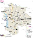
Dhule city is the administrative headquarter of the district. Dhule District Map gives the tourists a clear idea about the prime locations of the district.
Dhule District is situated between 20 38' and 21 61' N latitude and between 73 50' to 75 11' East longitude. The district shares its borders with Nandurbar district lying in the north-east, Nashik in the south and Jalgoan district lies to the east of Dhule District.
The district of Dhule has one prime river basin- the Tapi Basin. Satpuda Hill range lies in the northern part of the district. There are several tourist places in this district which are worth paying a visit. Some of them include:
- Prakashe
- Sarangkheda
- Laling Fort
- Anerdam
- Toranmal