
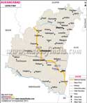

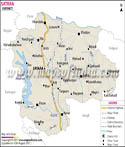
The Amravati district map helps travellers to get useful information about various features of the district.
Geographic Location of Amravati:
Situated at 20.30 to 21.50 degree of Latitude from the north and 76.35 to 78.27 North degree of Longitude from the east, Amravati district has an area of around 12,210 sq km. It is surrounded by the districts of Betul, Nagpur and Wardha, Yavatmal, Washim, Akola and Buldhana. The Wardha River flows through the eastern part of the district. The area of the irrigated land in hectors is about 6.38 lakh and the forest area stretches up to 3.88 lakh Hectors.
Major towns of Amravati:
Achalpur, Anjangaon Surji, Chikaldara, Warud, Morshi, Shendurjana Ghat, Chandurbazar, Paratwada, Daryapur, Nandgaon Khandeshwar, Badnera, Dharni
History of Amravati:
Historically called 'Udumbravati', the name Amravati is said to have emerged from the ancient Ambadevi temple situated in the district. Amravati finds mention on a stone inscription dating back to 1097. It is believed that in the 14th century Amravati district faced a famine because of which the people in Amravati migrated to Gujarat and Malwa; though some returned after a few years. It is understood that a Jumma Masjid was built here in the 16th century in Aurangpura, modern day Sabanpura. In 1722, the region was ruled by Shri Ranoji Bhonsale who reconstructed the city and it was hence called Bhonsale ki Amravati. Amravati was modernized when it came under the British rule. Many government buildings came up, along with a railway station. The city grew rapidly and was one of the richest towns by the end of 18th century.
In the year 1903, Amravati became a part of the Central Provinces and Berar. After independence, in the year 1956, Amravati district became yet another Mumbai state. Later after its partition in the year 1960 it became an independent district of Maharashtra. Lying in the River Tapi basin, this cotton growing region is a growing industrial centre with cotton mills also Chikaldara (hill station) is the only coffee growing area in Maharashtra.
The city is undergoing massive re-modelling and apart from being an industrial hub, it is becoming an attractive residential destination too; since the announcement that it will be developed as a smart city. Well connected with nearby cities by road, it also has NH6, connecting it to Gujrat, Orrissa and Chhatisgarh.
Amravati falls under Central Railway's Nagpur-Bhusawal section. The City's airport is located 15 km away at Belora and is run by Maharashtra Airport Development Company with another one coming up at Badnera.
Amravati District is famous for Betel leaves, piper longum (long pepper), Banana and orange.
Climatic Condition of Amravati:
Amravati district in Maharashtra experiences a tropical climate with hot and humid summers and cool and dry winters. The ideal time for visiting Amravati is between the months of October and March. The weather at this time of the year remains fine.
Languages spoken in Amravati:
Marathi, Hindi, Urdu and English happen to the primary spoken dialects.
Demographics of Amravati:
As per 2001 census the population of Amravati is 2,607,160. Female population is about 85.96 lakh whereas the male population is about 91.19 lakh.
Time Zone:
Amravati follows Asia/Kolkata time zone id.
Education in Amravati:
1. Engineering Colleges
- Government College of Engineering
- Sipna Shikshan Prasarak Mandals College Of Engineering
- College Of Engineering Badnera
- HVPM College Of Engineering
2. Medical Colleges
- Panjabrao Deshmukh Memorial Medical College
- Pandit Jawaharlal Nehru Memorial instutute of Homeopathic Medical Sciences
3. Other Colleges
- Shri.Ramkrishna Krida Vidhyalaya and College
- Bhartiya Mahavidhyalaya
- Vidarbha Maha Vidhyalaya (VMV) College
- Shri Shivaji Science and Arts College
River and tributaries in Amravati:
Take a look at the rivers and tributaries which flow through the district:
- Tapti River
- Burshi River
- Surkhi River
- Tigria River
- Khandu River
- Khapra River
- Sangiya River
- Gadaga River
- Purna River
- Aarna River
- Pedhi River
- Shahanur River
- Bhavkhuri Riverv
- Chandrabhaga River
- Bhuleswari River
- Vaan River
- Wardha River
- Vidarbha River
- Bor River
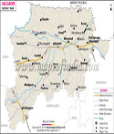
Tourist Attractions in Amravati:
There are numbers of tourist attractions in Amravati. The Amravati district map helps travellers by proving the location of these tourist spots. Lots of sightseeing tours are also offered by the local tourist board and other agencies. Some places which are mostly frequented by tourists are:
- Simbhora Dam also called the Upper Wardha Dam; it falls in the Morshi taluk of Amravati district.
- Deonath Math
- Gawilgarh Fort, a 300 year old stronghold of the Maratha Empire.
- Ambadevi Temple/ Goddess Shakti temple where Lord Krishna married Rukmini
- Koudanyapur is said to be the birth place of Rukmini.
- Shahanur/ Shahnoor Dam
In addition, travellers can opt for excursion trips as well to places such as:
- Chikhaldara Hill Station
- Gugarnal National Park
- Melghat Tiger Reserve
- Wan Wildlife Sanctuary
There are plenty of lodging centres and hotels in Amravati district which offer good facilities. Most hotels are in the vicinity of the main town center of Amravati and are easily accessible.
Hotels in Amravati:
- Hindustan International Hotel
- Mehfil Inn Hotel
- Ramgiri Hotel
- Tourist Hotel
- Rajadhani Hotel
- Samrat Hotel
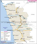
Getting to Amravati:
By referring to the Amravati district map, travellers can get an idea of the various routes available for reaching Amravati. The nearest airport is located in the city of Nagpur. Amravati is also a major station on the Central Railway line and is linked with places like Bhusawal, Wardha, Pune, Dhulghat, and Achalpur and so on. Road network is also developed.
Last Updated on : May 12, 2026