
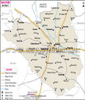

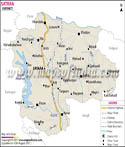
Akola District Map is there to guide the tourists so that they can enjoy Akola travel to the fullest. The city of Akola is the administrative center of the district.
Geographic Location of Akola:
Akola district is situated at latitude 20.7° north and longitude 77.07° east. Melghat Hills and forest region surround the Akola district. Akola is blessed by numerous water bodies like Morna River, Purna River, Vaan River, Aas River, Shahnur River etc. There are several dams in the district. Akola has encountered three floods since 1978. The portion covered by forests in Akola stretches to an area of 467 square kilometers.
Climatic Condition of Akola:
The climate of Akola is normally tropical. During the summers the temperature rises up to 48°C while during the winters in drops down up to 10°C. Situated on the tropic of cancer, days in the district become very hot. Comparatively, nights are cooler. The annual rainfall averages 850 mm.
History of Akola:
Initially, Akola was a district of Berar. The whole of Berar was a part of Vidarbha dominion. Later, Berar fell under Mauryan, Chalukya, Rashtrakutas, Mughal, Maratha dynasties. In the year 1853, the entire Berar was assigned to the British East India Company. After independence in 1956, Berar was segmented into different states. Akola earned its place as a bilingual state.
In 1960, Akola was divided into two states. Later in the year 1998, Akola district was further divided into two new districts.
Languages spoken in Akola:
The languages spoken here are basically Marathi, Hindi, Urdu and English. Marathi is the major language spoken by the people of Akola. Though, Urdu and Marathi are also spoken in a few communities.
Demographics of Akola:
According to 2001 India census, Akola district has a population of around 1,630,239. Languages. Number of males is about 8,41,253 whereas female population is about 7,88,986. Urban population is around 6,27,497 whereas the rural population is approximately 10,02,742.
Economy:
The economy of the district is primarily based on agriculture. Cotton and jowar are the chief crops produced in Akola. Best time to visit
Industries in Akola:
- Nocil Industries
- Maharashtra Insectsids
- Galaxy Plastics
- Basant Agro Tech Ltd
- Akola Zilla S. Sakhar karkhana
- Maharashtra Cotton Grower Fed
- Ruhatiya Spinners Pvt Ltd
- Vidarbha Publication Pvt Ltd
- Gujrat Ambuja Export Ltd
- Sawatram Mills
- P H Sales & Services Ltd
- Akola Chemicals (India) Ltd
- Rallies India Ltd
- 1 University (Agriculture)
- 1,136 Primary School (As per year 2003)
- 341 Secondary Schools (As per year 2003)
- 13 Sr. Colleges (As per year 2003)
- 16 Adivasi Ashram Schools (10 Primary , 6 Secondary)
- 1 Engineering College
- 3 Medical Colleges
The best time to visit Akola is between the months of October and June. Some of the popular attractions in Akola include:
- Akola Fort
- Atishay Kshatra Shri Antariksh Parshvanath Jain Temple
- Balapur Fort
- Jafarabad Fort
- Narnala Wildlife Sanctuary
- Narsingh Maharaj Mandir
- Teliyagad Fort
Tourists coming on a holiday trip to Akola will find multiple options for accommodation. Hotels in Akola are varied in number.
- Green Vallies Resort
- Greenland Cottages Hotel
- Jasnagra Hotel
- Shyam Guest House
- Center Plaza Hotel
- Skylark Hotel
- Regency Hotel
Akola follows Asia/Kolkata time zone id.
Reaching Akola:
Getting to Akola is easy and convenient. The nearest airport to Akola is Shivani Airport and the nearest railway station is Akola Junction. NH-6 passes through the district.
Akola is well-connected by rail and road to all the major towns and cities such as Mumbai, Delhi, Kolkata, Chennai, Hyderabad, Ahmedabad and Jaipur.
Distance to Akola
- From Mumbai - 611 KM
- From Hyderabad - 499 KM
- From Delhi - 1158 KM
- From Bangalore - 1061 KM
- From Nagpur - 250 KM
- From Pune - 468 KM
Last Updated on : May 12, 2026