
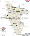

Apart from this, it is bordered by rivers from all directions. Rich in milk and culture, Kolhapur is rightly called city of palaces and gardens. The headquarters of Kolhapur district is located in Kolhapur city.
Geographic Location of Kolhapur:
Located on the banks of River Panchganga, Kolhapur is situated at a distance of 395 km to the South of Mumbai and 240 km from Pune. The district is located on the Pune - Bangalore National Highway No. 4.
Climatic Conditions of Kolhapur:
The climate in Kolhapur is generally tropical, nevertheless, pleasant. It is basically a combination of coastal and inland climate of Maharashtra. In the summers the temperature ranges from 34° C to 24° C.
om Pune - 233 KM
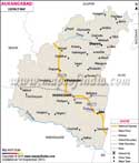
Demographics of Ahmednagar:
According to the 2001 census, Kolhapur city population's was 493167.
Time zone:
Kolhapur follows Asia/Kolkata time zone id.
Languages spoken:
Main languages spoken in Kolhapur are Marathi, Hindi and English. Marathi and Hindi are widely used by the major population. English is more common in the urban areas. While Marathi language rules in the other parts of the district.
Economy of Ahmednagar:
Kulhapur is an industrial city. Proximity to the bauxite deposits are of a great advantage to the town. Kolhapur comprises two major industrial areas, Gokulshirgaon and Shiroli which mainly produce aluminum castings, alloys, and bearings.
Kolhapur is a major Indian district that exports milk and milk-products. Jaggery production and Kolhapur chappals have made the district famous world-wide.
Renowned Educational institutes in Kolhapur:
Kolhapur University
Shivaji University
Kolhapur - Engineering Colleges
- Government College of Engineering, Kolhapur
- Kolhapur Institute of Technology [KIT], Kolhapur
- D.Y. Patil College of Engineering & Technology (DYPCET), Kolhapur
- Tatyasaheb Kore Institute of Engineering and Technology Warnanagar
- D.K.T.E. Society's Textile and Engineering Institute, Ichalkaranji
- Bharati Vidyapeeth's College of Engineering, Kolhapur
- CPR Government Medical College, Kolhapur
- D.Y.Patil Medical College, Kolhapur
- Krishna Institute of Medical Sciences, Karad [4]
- Yashwant Ayurvedic Medical College,Kodoli
- D.R.K. College of Commerce
- Vivekananda College
- Indumati College
- Hotel Hill Top
- Valley View Grand
- Hotel Panchshil
- Hotel International
- Hotel Ayodhya
- Hotel Vrishali Executive
- Hotel Shalini Palace
- Hotel Rajpurush
- Tourist Hotel
- Hotel Green Land (elegant)
- Dajipur Abhayaryana
- Narasinhawadi
- Mahalaxmi Temple
- New Palace and Chhatrapati Sahu Museum
- Town Hall Museum
- Old Palace
- Rankala Lake Jyotiba Temple
- Maharaja's Palace
- Shahuji Chhatrapati Museum
- Kotiteertha
- Irwin Agricultural Museum
- Vishalgad Fort
- Goddess Tryambuli Temple
- Bhavani Mandap
- Khasbag Maidan
- Rankala Lake
- Gaganbavada
- Gagangiri Maharaj Math
- Shalini Palace
- Radhanagari Dam
- Shivaji Vidyapeeth
- Katyani Devi Temple
- Kashi Vishveshawar Temple
- Holy Khidrapur (Kopeshwar)
- Kaneri Cloister
- Shankaracharya's Cloister
Last Updated on : May 12, 2026