
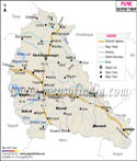

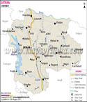
Geographic Location of Nandurbar:
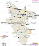
The talukas or administrative divisions included in the district are Akkalkuwa, Navapur, Nandurbar, Akrani, Taloda and Shahada.
To the south of the district is Dhule district, to the west and north is the state of Gujarat, to the north and east is the state of Madhya Pradesh. To the north of the district is the hill station of Toranmal. The hill station is 240 kilometers from Nashik, 47 kilometers from Shahada and 200 kilometers from Surat. Aurangabad is the closest airport to the hill station while the nearest railway station is located in Nandurbar .
Nandurbar District is subdivided into six taluks namely Akkalkuwa, Shahada, Akrani Mahal which is also known as Dhadgaon, Nandurbar, Taloda and Navapur. The nagarpalikas are Shahada, Navapur, Nandurbar and Taloda. The population of the district is around 13, 09, 135.
Marathi is the largest spoken language. Other than Marathi, English, Hindi and Urdu are widely used by the residents of Nandurbar.
Demographics of Nandurbar:
Male population is around 6,62,764 while that of females is 6,46,371.
Industries in Nandurbar:
- 346 Registered and running Factories
- 3 Co-operative Sugar Factories
- 2 Spinning Mills
- 1400 Cooperative Societies
- 159 Primary Agricultural Credit Societies
- 392 Cooperative Milk Societies
- Main crops cultivated in the Nandurbar district are jawar, wheat, rice, toor, groundnuts, chilly. Sugarcane and cotton are the annual crops. Fruits like Mango and Banana too grow in the district.
Nandurbar District has:
- About 1354 primary schools
- Approximately 257 Secondary schools
- Around 30 colleges for higher studies including Medical and Engineering
- 6 Government ITI and 2 private ITI
- Prakasha also called as Dakshin Kashi happens to be among the oldest temples of Nandurbar region. It is situated in Shahada Tehsil.
- Shri Datta temple located at Sarangkheda. A big fair is organized annually in this temple in the commemoration of Datta Jayanti.
- Toranmal is a hill station in Maharashtra state with a natural lake called Yashwant Lake. It's an interesting sight-seeing and picnic spot.
- Unapdev is another intriguing picnic spot in Shahada tehsil.
- NarayanPur is another region famed across for the remains of ancient Shiva temple in the Nandurbar Taluka.
- Lord Mahavir's sculpture in the Gomai River located near the taluka of Shahada is another interesting masterpiece of the location.
- Satpuda hills happen to be one of the most fascinating spot of the Nandurbar.
- Fort of Akka Rani, beautiful waterfalls of Horaphali and Walheri are other great points for sightseeing.
- Toranmal Hill Resort
Checkpost - Dhadgaon,
Nandurbar - 425432,
Maharashtra - Jyoti Guest House, Nandurbar
Near Nandurbar Railway Station
Nandurbar
Maharashtra - 425412
Numerous buses at regular intervals are available for the district. 10 direct trains from Mumbai to Nandurbar are available to take you too the beautiful district of Nandurbar. If by air is your option, take a flight from Mumbai to Aurangabad (nearest airport to Nandurbar). Thereon conveyance is available to reach the city via road.
Last Updated on : May 12, 2026