
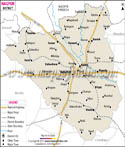

The district is filled with several temples and ponds and serves as a good weekend getaway. Travelers to this place can take the help of the Washim District map when moving in and around the district.
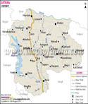
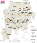
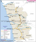
Location of Washim District:
The district is located in the Vidarbha Region of Maharashtra, India. The entire district occupies an area of about 5150 sq kilometer. The geographical coordinates of Washim District are 76 degree7 East Longitude and 19 degree 61 North Latitude. The Washim District Map shows that this district is surrounded by Akola, Amravati, Buldhana, Yavatmal and Parbhani. The Rivers Penganag and Aran pass through this district.
>
There are several temples and other interesting places in Washim District that are worth paying a visit. The main attractions of this place, which are an integral part of the tourist attractions in Maharashtra comprise of:
-
Padmateerth in Washim
-
Shri Nrusimha Saraswati Swami Maharaj (Guru Mandir) in Karanja
-
Shri Nath Nange Maharaj Temple Dawha in Malegaon
-
Shri Sakharam Maharaj Temple Loni in Risod
-
Chamunda Devi in Washim
-
Pohara Devi in Taluka Manora
-
Balaji Mandir in Washim
-
Antariksha Parshwanath Jain Mandir
- Shirpur Jain Mandir
Last Updated on : May 12, 2026