
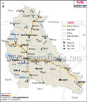

About
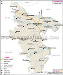
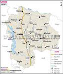
Southeastern Maharashtra holds Yavatmal, a quiet force within the bustling Vidarbha zone. Not far from here, fields stretch wide under open skies, rich with dark earth built for growing cotton. Locals call it the Cotton City, though outsiders sometimes say "capital"-either way, bales leave daily for mills nationwide. The land breathes farming; harvests pile high where machines hum through long seasons. Turn the name around, and you find clues: Yavat hints at hills, mal suggests ledges shaped by time. Such features frame the area, tucked beside the rough spine of the Balaghat range. Stone ridges rise in uneven lines, holding the flat farms like hands cupping grain. Spread across 13,582 square kilometers, Yavatmal sits high - around 445 meters up from sea level. Tucked into the lower-right edge of Amravati's zone, it touches rivers and nearby areas rather than sharp lines on maps. These flowing edges link lives, movement, trade - not drawn by rulers but by water and soil. Borders here breathe, shaped less by paper and more by how people meet . Up north, it touches Amravati alongside Wardha.
History & Culture
Old stories say that Yavatmal dates back to the kingdom of Vidarbha in the Mahabharata. Deep roots in ancient times mark its place across shifting empires. Under Ashoka’s rule, around 272 to 231 BCE, it grew strong within the Mauryan realm. Ruins scattered through time show life once flourished here. After the Mauryans faded, new powers rose one after another. First came the Satavahanas, then builders called the Vakatakas shaped stone like poets. Architecture changed when the Chalukyas arrived from Badami. Later, rulers known as Rashtrakutas held sway before others took their turn. Festivals bloom naturally where people gather - no announcement needed. Out here in Yavatmal's countryside, few things stir emotion like the Pola Festival. Days go by with farmers tending to every detail - scrubbing their bullocks clean, brightening horn tips with paint. Gratitude runs deep; these animals pull through backbreaking work on the land. Decoration becomes a quiet act of respect. Frenzied beats echo through city corners during Navratri, where towering pandals rise like temporary temples. Crowds pour in from nearby areas drawn by rhythm and color. Elaborate dances unfold each night under strings of bright lights. Celebration pulses strongest in these urban hubs. Meanwhile, Ganeshotsav hums with its own steady cadence - idols arrive amid chants, and homes open their doors wide. Festivals known as Tribal Jatras happen every year to honor village gods such as Rangnath Swami. While music fills the air, people perform powerful native dances including Dhol and Dhangari Gaja.
Economy
Farming drives Yavatmal's economy, though its layout stretches into offices, factories, and markets in uneven but connected ways. While fields dominate, activity spills into varied sectors - each shaped by different rhythms and demands.
Government Sector
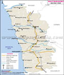
Most jobs in Yavatmal tie back to government work. Big numbers live here - more than two point seven million - a figure that demands systems just to keep things running. Running those systems means hiring many hands. At the core sits the District Collectorate, a central hub. Sprouting from it are sixteen Tehsil offices, each handling local tasks. Together they make up the backbone of daily administration. Starting strong, the government powers economic growth by pouring funds into big projects - take the Maharashtra Shaktipeeth Expressway linking Nagpur to Goa, slicing right across areas including Arni and Umarkhed.
Public Sector
Most of the time, government activity in Yavatmal moves through banks, farm trade groups, and local co-ops. Because so much of the area is countryside, outfits such as the Yavatmal District Central Co-operative Bank, along with several state-run banks, keep farming alive by offering loans. Out in the open fields, farming goods change hands at large government-backed market centers run by APMC. Power supply services handled by MSEDCL, along with tree-covered land management efforts, keep many employees busy across areas that make up close to one-fifth of the region’s map space.
Services Sector
Now driving Yavatmal’s shift away from only crops, service work fills more space than before across twenty years. What began as fields now holds shops, transport links, learning centres - each feeding change without force. Growth did not arrive overnight; instead it crept through rising needs, widening roads, sharper phones. Banking shows up stronger here today, alongside clinics that stay open longer. Teaching jobs grow, tied less to land, more to schedules and skill. Movement of goods brings fuel stations, repair spots, storage rooms with guards at night. Even farming leans on advice now - weather tips, price updates, delivery plans handled off soil. The old way fades slowly while these roles take root like vines on stone.
Tourism
What pulls people to Yavatmal isn’t just one thing - it’s temples sitting quiet beside wild green spaces, old structures cared for over time. Pilgrims find corners to reflect while others wander trails, breathing deep under trees. History stays alive here without shouting about it, simply showing up in stone and silence. Nature does its part too, unfolding beyond shrines into stretches of untouched land. Each spot fits next to the other, not forced, just there - waiting without asking much at all.
Sahastrakund Waterfall
Down where the district ends, along the Penganga River, lies a stunning waterfall shaped by nature’s slow hand. Water plunges off a sheer cliff into a narrow valley below, cloaked always in soft spray. Around it, layers of stone look like staircases, worn that way over ages by rushing flows. Right after rains ease, visitors often arrive - families, photographers - drawn by the cool air and green surroundings. Each curve of rock tells time differently, quiet yet bold.
Chintamani Temple Kalamb
Buried beneath the earth, this old temple honors Lord Ganesha in quiet reverence. What sets it apart? The statue rests underground, housed in a carefully carved chamber below surface level. Centuries have passed, yet people keep coming - records confirm its importance long before modern times. Fed by unseen springs, the pool nearby, known as Ganesh Kunda, holds meaning for those who live here. Few places carry such weight through silence alone.
Demographics
Out here in Yavatmal, you see towns slowly growing while wide stretches stay deeply rooted in village life. Tribal communities shape much of the land, their presence clear in daily rhythms. A closer look reveals how change moves unevenly - some areas shift toward city ways, others hold fast to older patterns. This blend defines the region, not as two worlds apart but as layers living side by side. Total Population: 27,72,348 . Rural Majority 78 Percent. Urban Share 22 Percent. Males Slightly More Than Females. Slight Female Deficit Per Thousand Males. Density Around 153 People Per Square Kilometer. Basic Reading Skills Above Eighty Percent. Literacy Higher Among Adults Over Seven. Many tongues shape how people talk here. Marathi leads, used in offices and homes, with over two-thirds speaking it, often in the lively local form called Varhadi found in Vidarbha. Since the area stretches along Telangana’s edge and welcomes many traveling and forest communities, speech varies sharply from one township to another. Other languages thrive because borders blur and cultures mix near the south. Talk shifts depending on where you stand within the region’s blocks. Lambadi, sometimes called Gormati, shows up in about 13.29 percent of speakers across the region; meanwhile, Urdu holds space at 5.41 percent. Close behind comes Hindi with nearly five percent usage. In some areas, smaller tribal tongues appear - Kolami surfaces around 2.77 percent, while Gondi trails slightly lower at 2.41 percent. Down south, near boundary settlements, Telugu slips into conversation now and then.
Administration
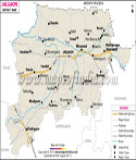
Deep inside Yavatmal, layers of local control unfold piece by piece, keeping order across wide stretches of land. Running things from the top sits the District Collector and Magistrate, guiding daily operations. Rural progress leans on help that flows through the Zilla Parishad's CEO, shaping growth where it’s needed most. Seven parts make up the district, each helping manage tasks more closely. Revenue work happens here, along with keeping land documents straight. Disagreements locally find answers at these spots too. These sections go by another name - Tehsils, sometimes called Talukas. One handles matters in its area while staying linked to broader oversight. Not every part works alone; they connect under shared systems. There are sixteen of them altogether. Out here, city areas fall under 16 Municipal Councils handling roads, buildings, and layout plans. Spread across wide countryside patches, more than a thousand small village units - called Gram Panchayats - take care of water, power, health, and basic living demands.
FAQs
Q1: How many villages are there in Yavatmal district altogether?
Some 1853 revenue villages make up Yavatmal district.
Q2: What is the total population of the Yavatmal district?
Out here in Yavatmal district, the count hits exactly 2,772,348 folks when you add up everyone. Most call village homes their base - that number runs high at 2,174,195. Towns and cities hold the rest, tallying up to 598,153 souls spread across urban zones.
Q3: What is Yavatmal Known for ?
Out past Mumbai, Yavatmal wears the title Cotton City like a badge stitched into red soil. Where rows stretch wide under hot sun, white bolls split open waiting for hands or blades. Factories buzz at odd hours, never quiet, turning fluffy harvests into tight bundles. This rhythm - spinning, pressing, shipping - has shaped days here longer than most remember.
Last Updated on : July 21, 2026