


About
Water carves this land, shaping everything slowly. Old habits live here alongside smoke from newer machines. The Kaveri river slips close, fed by the quieter Kollidam arm - together they feed soil, prayers, settlements. Around three hundred twenty kilometers from Chennai, give or take, you reach it. Southward, another one fifty takes you toward Madurai. Movement never stops; travelers drift through like dust on the wind. Just saying "Tiruchirappalli" opens a door to old stories and word origins. From Tamil it comes, shaped by time and belief. Some say Thiru-Chiri-Palli hides behind it - Thiru being a mark of holiness, like calling something blessed. Then there's Chiri, twisted from Chira, tied to Trishira - a demon with three heads, kin to Ravana in the Ramayana - who once meditated hard on these grounds seeking Shiva’s favor. Palli? That means a dwelling set apart for prayer, a holy ground built around faith. So altogether, it becomes the place where that fire-eyed spirit sought grace. Others argue differently, though - one scholar might whisper of Tiru-chinna-palli instead: a sacred small village tucked into history. Another voice hints at monks carving silence into stone, since palli also meant shelters made by Jains long ago, their caves still clinging to cliffs scattered through the land.
History & Culture
Old stories from Trichy unfold much like tangled threads in southern India’s power struggles. Long before now, during the first days of the Chola rule around 300 BCE, records started appearing. A place called Uraiyur - now just part of busy Tiruchirappalli - once wore the crown as home base for those early Cholas. From these streets, mighty rulers such as Karikala Chola sent ships trading goods all the way to Rome. When kingdoms climbed to power and then collapsed, this key stretch along the river changed rulers again. In time, by around 500s AD, the Pallavas took charge - carving the first stone shelters straight into the cliffside during their reign. Power passed next to the medieval Cholas in the 800s, who turned nearby wetlands into rich farmlands. After them came flashes of rule: the Pandyas stepped in, then the Hoysalas, each holding sway for a short span. That solid structure of Trichy, the one seen now, began forming during the rule of the Vijayanagara kings, followed by their appointed leaders in Madurai. During the 1500s and 1600s, Viswanatha Nayak saw what others missed - the giant rock offered unmatched defense. Because of that, he strengthened the town, raised thick barriers around the Rockfort, and then Chokkanatha continued his work. For a stretch of time, power moved from Madurai straight into Trichy instead. Back then, around the 1700s, Trichy erupted into chaos during fierce clashes tied to European powers fighting through local allies. While the British backed Nawab Muhammed Ali Khan Wallajah, their rivals - the French - stood with Chanda Sahib. At the heart of it all stood Rockfort, where battle lines hardened into legend. A bold stand there, shaped by Robert Clive’s actions, tilted power sharply toward Britain across southern lands. That moment quietly sealed what would come later: decades of British control rooted in military edge. Under colonial rule, the area held strategic weight, hosting troops and rail operations right up to 1947. When India finally stepped into self-rule, that era ended - not with noise, but time.
Economy
Farming holds strong here, while factories hum alongside new kinds of office work spreading fast. Trichy's money engine runs on many tracks at once.
Government Sector and Public Sector
What shapes Trichy’s industry today? Big government-run factories built in the 1900s hold that role. Leading them all: Bharat Heavy Electricals Limited, set up in 1965. Not just a factory - this place runs like its own city. It makes top-tier boilers and gear for power stations, recognized far beyond India. Because of it, Trichy stopped being sleepy, grew loud with machines. Hundreds of smaller workshops followed, feeding off its presence - one after another, more than five hundred now. Life here changed when steel started flowing. Trichy holds the Golden Rock Railway Workshop, run by Southern Railway since 1928. That site stands among India’s top railway repair centers, known for rebuilding diesel-electric engines.
Services Sector
Trichy powers jobs through education and local growth. Because college halls keep sending out engineers, companies see reason to stay. What follows is more screens lighting up offices where young minds once only studied. Most jobs in services come from shops and places that serve people food or drinks. Near where buses arrive downtown and at Chathiram, businesses are always busy. People from nearby areas travel here to buy gold, cloth, and everyday items because Trichy leads trade. Medical care has grown fast thanks to large hospitals offering many treatments, drawing patients across central Tamil Nadu.
Tourism
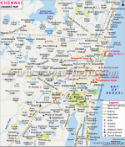
On an island where the Kaveri meets the Kollidam, sits a vast temple that shapes much of what draws people to Trichy. Honoring Lord Ranganatha - Vishnu resting on water - it holds claim as the biggest active Hindu temple site anywhere, covering 156 acres without crowding the land. Think of it as a sacred town built within itself, surrounded by seven-layered stone enclosures called prakarams, each deeper than the last. Towering above are 21 gopurams, their peaks reaching skyward like sentinels of craft and faith. Among them, the Rajagopuram climbs 73 meters high, standing among Asia’s most massive constructed spires. Many come simply to walk through the hall marked by a thousand pillars, where carved warrior figures ride horses frozen mid-gallop.
The Rockfort Temple Complex
High above, this towering structure shapes how the city looks from afar. Reaching the top means walking more than 400 stairs carved long ago into solid stone. Along the way, travelers pass first one temple then another - first, a shrine built for Shiva, where walls rise straight from rock and hold within them a large sacred symbol; after that comes another place of worship near the sky, honoring Ganesha.
The Kallanai Grand Anicut
About twenty kilometers beyond the city stands Kallanai, an old feat of engineering craft. Built during the second century by King Karikala of the Chola line, it remains among the earliest working water diversion systems on Earth. Stones, uncut and laid across the moving riverbed of the Kaveri, form its base structure. Water shifts course through the delta arms because of this barrier, feeding wide fields below. Floods that once surged with seasons now ease their flow, thanks to this design's balance. Where chaos ruled before, growth spreads - rice thrives where dry land used to be.
Demographics
One place in southern India called Tiruchirappalli sits within Tamil Nadu. Back when people counted everyone in 2011, there were 2,722,290 living here - a big share for the region’s numbers. Males made up 1,352,284 of that group, while females came in slightly higher at 1,370,006. Because of its size and location, it helps shape how things run across nearby areas. Work happens here, decisions get made - part of what keeps the zone moving. Females outnumber males in Tiruchirappalli district by 13 more per thousand people, a number that lines up well with India’s overall figure. The balance between genders here tells something about how society functions locally. Over time, what we see in the numbers shifts slightly with each new census round. One out of every three people here can read and write, placing Tiruchirappalli above average in learning progress. Boys and men tend to attend school more often, reaching nearly nine out of ten literate. Girls lag slightly behind, with about seven out of ten able to read. That leaves a difference close to thirteen percent between them. Officials continue pushing efforts into classrooms rather than cutting corners elsewhere.
Administration
Under the District Collector's guidance, Tiruchirappalli splits into levels - each shaped for smoother operations. Governance flows through layers designed to handle services, administration, and income collection without clutter. Structure follows function here, where oversight meets local needs quietly. Order comes from how parts connect, not just their number. Most of the area lives in the countryside, where 507 Revenue Villages form the base of local management. Out here, villages cluster under local councils known as Panchayats, bundled into larger units called blocks. These groupings make it easier to deliver basics - roads show up where they’re needed, clean water reaches homes, and classrooms appear in corners once ignored. Inside city limits, though? Different setup entirely. The Tiruchirappalli City Municipal Corporation takes charge there, stepping in place of rural systems. It slices the urban space into tiny sections named wards. From that grid, work flows outward: each zone gets attention one piece at a time, order held block by quiet block.
| Facts of Tiruchirappalli District | |
|---|---|
| Official Name | Tiruchirappalli |
| Location | Tamil Nadu |
| Area | 4509 sq. km |
| Population | 2,722,290 |
| Language | Tamil, English |
FAQs
Q1: How many villages are there in Tiruchirappalli district altogether?
Most folks don't realize - Tiruchirappalli holds exactly 558 villages revenue villages. Scattered through 11 separate taluks, each area plays its part differently. Administration works better because these spots link up under rural development blocks. Local needs like farming progress or support programs get handled closer to home that way.
Q2: How many people live in the Tiruchirappalli district?
Back when people counted everyone in 2011, there were 2,722,290 living here - a big share for the region’s numbers.
Q3: What is Tiruchirappalli District Known For ?
Home to both sacred sites and heavy machinery, Trichy stands apart. Not just temples rise here - towering industry does too. The sprawling Ranganathaswamy Temple at Srirangam draws pilgrims; nearby, the Rockfort clings stubbornly to a boulder. Factories hum where history once whispered, thanks to BHEL anchoring engineering work on a vast scale. Older still, the railway workshop at Golden Rock keeps wheels turning through the decades. Beyond steel and steam, bunches of bananas travel far from local farms. Long ago, Chola rulers called this place their seat of power - echoes remain.
Last Updated on : July 16, 2026