


Bihar districts
Bihar is a state in India that is situated to the eastern side of the country. The district is the 12th largest in terms of land and ranks third in terms of population. Interesting thing to note here is that the population of Bihar is mostly of youngsters below 25 years, which is the country's highest proportion. River Ganges flows through the center of the state making two divisions. The language of the state is Hindi and Urdu and other languages as well.
Districts of Bihar
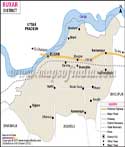
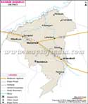
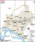
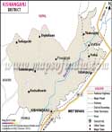
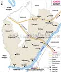
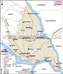
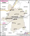
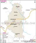
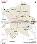
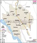
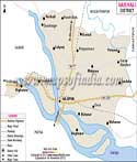
To begin with the capital of Bihar is Patna, and is one of the 38th districts of the state. Even the head quarters is in Patna and is regarded as the most populous district of the state. including Patna, Bihar has 38 district altogether namely: Araria, Bettiah, Motihari, Sitamarhi, Arwal, Aurangabad, Banka, Bhagalpur, Buxar, Madhepura, Madhubani, Monghyr, Nalanda, Nawada, Buxar, Purnea, Darbhanga, Rohtas, East Champaran, Saharsa, Gaya, Samastipur, Gopalganj, Saran, Jamui, Shiekhpura, Jehanabad, Sheohar, Kaimur, Sitamarhi, Katihar, Siwan, Khagaria, Supaul, Kishanganj, Vaishali, Lakhisarai, West Champaran.
Location of Bihar
Bihar is surrounded by Nepal to the north, the state of Uttar Pradesh to the west, West Bengal to the east and Jharkhand to the south. Bihar state lies approximately between 21 degree 58'10" and 27 degree 31'15" N and latitudes 82 degree 19'50" and 88 degree 17'40" E longitude. It is a land locked state and is to the east of the country.
Important Districts
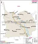
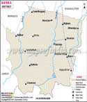
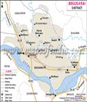
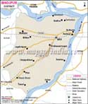
Every district is distinct and is significant in its own way. Araria is famous for the jute mills and cultivation of crops like Paddy and maize. The Aurangabad district is known for the woolen carpets and blankets. Gaya is important for its heritage site Bodhgaya, which is an important pilgrimage site of Buddhism. Buxar and Dharbanga are very important districts of the state and they produce crops like rice, sugarcane and wheat in huge quantities. Nalanda and Patna are world famous for their rich and historic significance. Kaimur has a wildlife sanctuary which attracts the tourists. Some districts have attracted the tourists for centuries for the religious significance, the natural beauty and the educational importance. Such districts are the Nalanda, Vaishali, Gaya etc.
Patna, Muzaffarpur, Gaya and many other districts are well connected by a network of railway. They are connected to various parts of the country. National Highways Nos. 2, 31, 28, 23, 30, and 33 run through various districts of the state.
List of Districts in Bihar
| Sr. No. | District | District HQ | Population (2011) | Growth | Sex Ratio | Literacy | Area (km2) | Density (/km2) |
|---|---|---|---|---|---|---|---|---|
| 1 | Araria | Araria | 2811569 | 30.25% | 921 | 53.53 | 2829 | 992 |
| 2 | Arwal | Arwal | 700843 | 18.89% | 928 | 67.43 | 4839 | 1099 |
| 3 | Aurangabad | Aurangabad | 2540073 | 26.18% | 926 | 70.32 | 3303 | 760 |
| 4 | Banka | Banka | 2034763 | 26.48% | 907 | 58.17 | 3018 | 672 |
| 5 | Begusarai | Begusarai | 2970541 | 26.44% | 895 | 63.87 | 1917 | 1540 |
| 6 | Bhagalpur | Bhagalpur | 3037766 | 25.36% | 880 | 63.14 | 2569 | 1180 |
| 7 | Bhojpur | Arrah | 2728407 | 21.63% | 907 | 70.47 | 2473 | 1136 |
| 8 | Buxar | Buxar | 1706352 | 21.67% | 922 | 70.14 | 1624 | 1003 |
| 9 | Darbhanga | Darbhanga | 3937385 | 19.47% | 911 | 56.56 | 2278 | 1721 |
| 10 | Gaya | Gaya | 4391418 | 26.43% | 937 | 63.67 | 4978 | 880 |
| 11 | Gopalganj | Gopalganj | 2562012 | 19.02% | 1021 | 65.47 | 2033 | 1258 |
| 12 | Jamui | Jamui | 1760405 | 25.85% | 922 | 59.79 | 3099 | 567 |
| 13 | Jehanabad | Jehanabad | 1125313 | 21.68% | 922 | 66.8 | 1569 | 1206 |
| 14 | Kaimur | Bhabua | 1626384 | 26.17% | 920 | 69.34 | 3363 | 488 |
| 15 | Katihar | Katihar | 3071029 | 28.35% | 919 | 52.24 | 3056 | 1004 |
| 16 | Khagaria | Khagaria | 1666886 | 30.19% | 886 | 57.92 | 1486 | 1115 |
| 17 | Kishanganj | Kishanganj | 1690400 | 30.40% | 950 | 55.46 | 1884 | 898 |
| 18 | Lakhisarai | Lakhisarai | 1000912 | 24.77% | 902 | 62.42 | 1229 | 815 |
| 19 | Madhepura | Madhepura | 2001762 | 31.12% | 911 | 52.25 | 1787 | 1116 |
| 20 | Madhubani | Madhubani | 4487379 | 25.51% | 926 | 58.62 | 3501 | 1279 |
| 21 | Munger | Munger | 1367765 | 20.21% | 876 | 70.46 | 1419 | 958 |
| 22 | Muzaffarpur | Muzaffarpur | 4801062 | 28.14% | 900 | 63.43 | 3173 | 1506 |
| 23 | Nalanda | Bihar Sharif | 2877653 | 21.39% | 922 | 64.43 | 2354 | 1220 |
| 24 | Nawada | Nawada | 2219146 | 22.63% | 939 | 59.76 | 2492 | 889 |
| 25 | Pashchim Champaran | Bettiah | 3935042 | 29.29% | 909 | 55.7 | 5229 | 753 |
| 26 | Patna | Patna | 5838465 | 23.73% | 897 | 70.68 | 3202 | 1803 |
| 27 | Purbi Champaran | Motihari | 5099371 | 29.43% | 902 | 55.79 | 3969 | 1281 |
| 28 | Purnia | Purnia | 3264619 | 28.33% | 921 | 51.08 | 3228 | 1014 |
| 29 | Rohtas | Sasaram | 2959918 | 20.78% | 918 | 73.37 | 3850 | 763 |
| 30 | Saharsa | Saharsa | 1900661 | 26.02% | 906 | 53.2 | 1702 | 1125 |
| 31 | Samastipur | Samastipur | 4261566 | 25.53% | 911 | 61.86 | 2905 | 1465 |
| 32 | Saran | Chhapra | 3951862 | 21.64% | 954 | 65.96 | 2641 | 1493 |
| 33 | Sheikhpura | Sheikhpura | 636342 | 21.09% | 930 | 63.86 | 689 | 922 |
| 34 | Sheohar | Sheohar | 656246 | 27.19% | 893 | 53.78 | 443 | 1882 |
| 35 | Sitamarhi | Sitamarhi | 3423574 | 27.62% | 899 | 52.05 | 2199 | 1491 |
| 36 | Siwan | Siwan | 3330464 | 22.70% | 988 | 69.45 | 2219 | 1495 |
| 37 | Supaul | Supaul | 2229076 | 28.66% | 929 | 57.67 | 2410 | 919 |
| 38 | Vaishali | Hajipur | 3495021 | 28.57% | 895 | 66.6 | 2036 | 1717 |
Last Updated on : June 25, 2025