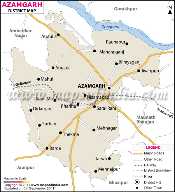
Azamgarh district occupies 4234 sq.km.of Uttar Pradesh district. It is located between 25 ° 38'' and 26° 27' North of latitude and the meridians of 82° 40 ' and 83° 52' East of longitude. It is bounded by Mau on the east, Gorakhpur on the north, Ghazipur on the south-east, Jaunpur on the south- west, Sultanpur on the west and Ambedkar Nagar on the north-west. As per 1991 census, the total population of the district is 31,53,885, including 15,71,590 men and 15,82,290 women.
The main occupation of the people of Azamgarh district is agriculture. They are involved in the cultivation of pulses, oil seeds, sugar cane, and potato. They also grow fruits like mango and guava. The district is not industrially well developed. The major industries of the district are Kisan Sahkari Chini Mills Ltd., Benarasi Sari Udyog, in Mubarakpur, Black Pottery, in Nizamabad, Foods And Allied Products, and Chemicals And Allied Products.
The major tourist attractions of Azamgarh district are:
- Shrine of Bhiron Baba
- Temple of Thakurji, Mubarakpur
- Gurudwara at Nizamabad
- Ashram of Dattatreya Rishi
- Ashram of Durvasa Rishi
| Facts of Azamgarh District | |
|---|---|
| State | Uttar Pradesh |
| District | Azamgarh |
| District HQ | Azamgarh |
| Population (2011) | 4613913 |
| Growth | 17.11% |
| Sex Ratio | 1019 |
| Literacy | 70.93 |
| Area (km2) | 4053 |
| Density (/km2) | 1139 |
| Tehsils | Azamgarh, Burhanpur, Lalganj, Mehnagar, Nizamabad, Phulpur, Sagri |
| Lok Sabha Constituencies | Azamgarh, Lalganj |
| Assembly Constituencies | Atrauliya, Azamgarh, Didarganj, Gopalpur, Lalganj, Mehnagar, Mubarakpur, Nizamabad, Phoolpur Pawai, Sagri |
| Languages | Hindi, Avadhi, Urdu, English, Bhojpuri |
| Rivers | --- |
| Lat-Long | 26.073437,83.18563 |
| Travel Destinations | Shirne Of Bhiron Baba, Temple Of Thakurji, Jamiatul Falah, Aljamiatul Ashrafia etc. |
| Government Colleges/Universities | Shibli National College, Rajendra Prsad Collage Of Manegment, D.A.V. Collage etc. |
Last Updated on : January 14, 2026
