| Click any neighbouring District / State and get the Detailed District Map |
 |
District Map of Sonbhadra |
|
 |
|
 |
|
|
|
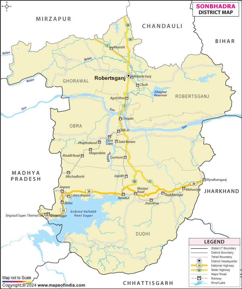
*The Map showing the National Highway, Major roads, other Roads, District Headquarter, Town, etc in the Sonbhadra District, Uttar Pradesh |
Disclaimer
|
Close Disclaimer: All efforts have been made to make this image accurate. However Mapping Digiworld Pvt Ltd and its directors do not own any responsibility for the correctness or authenticity of the same. |
Sonbhadra is a district of
Uttar Pradesh. It covers an area of 6788 sq.km. It has a population of 18,62,612 at per 2011 census. The Son river flows across this beautiful place.
A number of power stations have been established in Sonbhadra district which makes it the power capital of India.
| Facts of Sonbhadra District |
|---|
| State | Uttar Pradesh |
| District | Sonbhadra |
| District HQ | Robertsganj |
| Population (2011) | 1862559 |
| Growth | 27.27% |
| Sex Ratio | 918 |
| Literacy | 64.03 |
| Area (km2) | 6788 |
| Density (/km2) | 274 |
| Tehsils | Dudhi, Ghorawal, Robertsganj |
| Lok Sabha Constituencies | Robertsganj |
| Assembly Constituencies | Duddhi, Ghorawal, Obra, Robertsganj |
| Languages | Hindi, Urdu |
| Rivers | Sone, Rihand, Kanhar |
| Lat-Long | 24.457151,83.000908 |
| Travel Destinations | Vijaygarh Fort, Naugarh Fort, Aghorigarh Fort, Sodharigarh Durg, Vir Lorik Patthar etc. |
| Government Colleges/Universities | Gurudwara Inter College, Rail Karmchari Inter College, Gov. Girls Inter College, Bhartiya Inter College, Govt. Inter College, G.N. Balika Inter College, R.S.M. Inter College etc. |
Last Updated on : January 14, 2026
