| Click any neighbouring District / State and get the Detailed District Map |
 |
District Map of Banda |
|
 |
|
 |
|
|
|
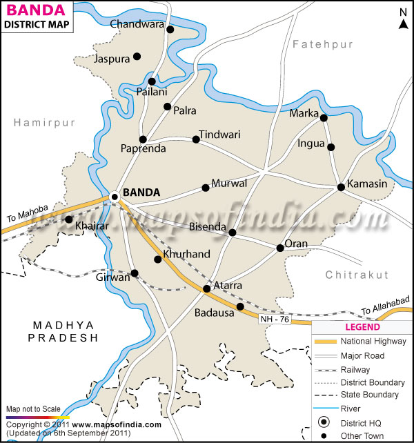
*The Map showing the National Highway, Major roads, other Roads, District Headquarter, Town, etc in the Banda District, Uttar Pradesh |
Disclaimer
|
Close Disclaimer: All efforts have been made to make this image accurate. However Mapping Digiworld Pvt Ltd and its directors do not own any responsibility for the correctness or authenticity of the same. |
The district of Banda situates itself from 24°53' to 25°55' North Latitudes and 80°07' to 81° 34' East Longitudes. As per the census of 2001, Banda is home to 15, 00,253 people.
Agriculture, animal husbandry, bio-gas plants and small-scale industries moulds the economic map of Banda.
Places to see:
- Kalinjar fort
- Bhuragarh fort
- Rangarh fort
- Khatri pahar
- Nawab tank
- Bamdeo temple
- Maheshwari devi temple
- Stone pillars at Kairada.
| Facts of Banda District |
|---|
| State | Uttar Pradesh |
| District | Banda |
| District HQ | Banda |
| Population (2011) | 1799410 |
| Growth | 17.05% |
| Sex Ratio | 863 |
| Literacy | 66.67 |
| Area (km2) | 4413 |
| Density (/km2) | 404 |
| Tehsils | Atarra, Baberu, Banda, Naraini |
| Lok Sabha Constituencies | Banda |
| Assembly Constituencies | Baberu, Banda, Naraini, Tindwari |
| Languages | Hindi including Bundeli |
| Rivers | --- |
| Lat-Long | 25.483571,80.333011 |
| Travel Destinations | Bamdeo Temple, Maheshwari Devi Temple, Kalinjar Fort, Bhuragarh Fort, Rangarh Fort, Nawab Tank, Four Stone Pillar, Khatri Pahar etc. |
| Government Colleges/Universities | D.A.V. Inter College, Khanqah Inter College, Government Inter College(Gic), Government Girl Inter College(Ggic), Saraswati Vidya Mandir Inter College, Government Mahila Degree College, Raja Devi Degree College, B.P.M.P.Omer Inter College, Aadarsh Inter College etc. |
Last Updated on : January 14, 2026
