| Click any neighbouring District / State and get the Detailed District Map |
 |
District Map of Bareilly |
|
 |
|

|
|
|
|
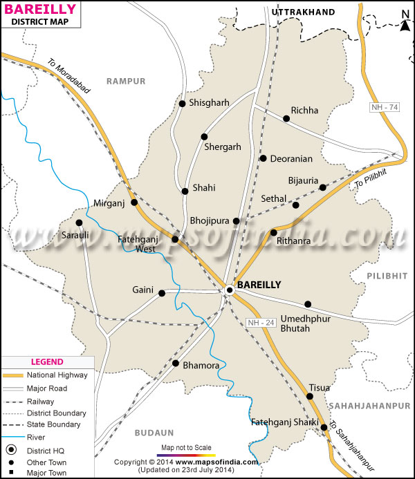
*The Map showing the National Highway, Major roads, other Roads, District Headquarter, Town, etc in the Bareilly District, Uttar Pradesh |
Disclaimer
|
Close Disclaimer: All efforts have been made to make this image accurate. However Mapping Digiworld Pvt Ltd and its directors do not own any responsibility for the correctness or authenticity of the same. |
The district of Bareilly stretches from 28?10' to 28?54'North latitudes and 78?58' to 79?47' East longitudes. Total population count as per 1991 census is 28, 55,556.
Bareilly is specially known for zardozi, a popular form of embroidery. Handicrafts, bamboo artwork and wooden furniture are also of importance in the district's economy.
Bareilly enjoys the privilege of its proximity to Delhi and
Lucknow and thus provides easy access to a lot of tourist places like Nainital, Tapovan and Pithoragarh.
.
| Facts of Bareilly District |
|---|
| State | Uttar Pradesh |
| District | Bareilly |
| District HQ | Bareilly |
| Population (2011) | 4448359 |
| Growth | 22.93% |
| Sex Ratio | 887 |
| Literacy | 58.49 |
| Area (km2) | 4120 |
| Density (/km2) | 1084 |
| Tehsils | Aonla, Baheri, Bareilly, Faridpur, Meerganj, Nawabganj |
| Lok Sabha Constituencies | Bareilly, Aonla (partly) |
| Assembly Constituencies | Aonla, Baheri, Bareily, Bareily Cantt., Bhojipura, Bithari Chainpur, Faridpur, Meerganj, Nawabganj |
| Languages | Hindi, English, Urdu, Punjabi, Kumaoni |
| Rivers | --- |
| Lat-Long | 28.368444,79.429679 |
| Travel Destinations | Madhinath Temple, Dopeswarnath Temple , Alaknath Temple, Trivatinath Temple, Ganga Temple, Army Service Corps Museum, The Panchala Museum, Ramnagar Fort, The Ahshar Viharm Gandhi Udyan, Executive Park etc. |
| Government Colleges/Universities | Rohilkhand University, Rani Awanti Bai Lodhi Govt. Girls College, Dr. Ram Manohar Lohia, Govt. Degree College, Bareilly College etc. |
Last Updated on : January 14, 2026
